12 Most Beautiful Places to Visit in Iceland According to Quora: Fire, Ice & Beyond

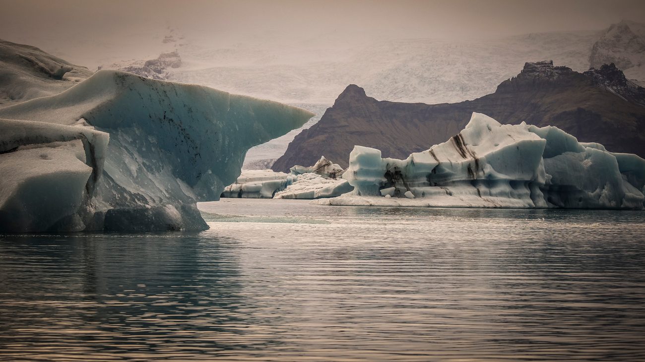
Sculpted millennial blue icebergs drifting through the serene waters of Jökulsárlón Glacier Lagoon toward the Atlantic Ocean.
There is no place on this planet where the raw, violent machinery of the Earth is more exposed than Iceland. I remember stepping out of my camper van on the black volcanic plains near Vík at midnight during midsummer. The wind was howling off the North Atlantic with ferocious momentum, carrying the sulfurous bite of active volcanic fissures, while the midnight sun cast a bizarre, permanent golden-lavender twilight across towering hexagonal basalt columns. It felt less like visiting another country and more like setting foot on an uninhabited moon.
When you scan the most passionate Iceland travel discussions on Quora—frequented by Icelandic search-and-rescue volunteers, Reykjavik photographers, and travelers who have circumnavigated the 828-mile Ring Road (Route 1) multiple times—one message rings loud and clear: do not just stay in Reykjavik and take day buses around the Golden Circle.
While the Golden Circle is impressive, Iceland’s true soul reveals itself when you venture further afield: into the multi-hued volcanic Highlands, along the desolate fjords of the east coast, and onto glacial shores where thousand-year-old blue ice washes up like diamonds on jet-black sand.
If you are planning an expedition to the Land of Fire and Ice, here are the 12 most beautiful places in Iceland according to seasoned Quora travelers.
1. Jökulsárlón Glacier Lagoon & Diamond Beach (South Coast)
Sitting at the foot of Breiðamerkurjökull, an outlet glacier of the colossal Vatnajökull ice cap, Jökulsárlón is Iceland’s crown jewel. Here, colossal chunks of ancient ice—often glowing deep sapphire blue or striped with black volcanic ash from eruptions centuries ago—calve directly into a deep 800-foot lagoon. Harbor seals pop their curious heads out of the freezing water, swimming between drifting bergs that creak and roll with the tide.
Just across Route 1, where the lagoon empties into the Atlantic Ocean, lies Diamond Beach (Breiðamerkursandur). Chunks of ice ground down by ocean breakers wash ashore onto pitch-black basalt sand. Standing beside an iceberg the size of an automobile, completely translucent and glistening in the morning sunlight against the obsidian sand, is an ethereal, dreamlike encounter.
- Quora Traveler Wisdom: Many Quora photographers emphasize: "Visit Jökulsárlón twice—once in late afternoon for golden hour reflections, and again at sunrise. The ice shifts continuously; no two hours on Diamond Beach are ever identical."
- Safety Warning: Never attempt to climb onto floating icebergs in the lagoon; they can flip over without warning in a fraction of a second, trapping you beneath freezing water.
2. Reynisfjara Black Sand Beach & Basalt Stacks (Vík)
Located near the southernmost village of Vík í Mýrdal, Reynisfjara is widely ranked among the most dramatic non-tropical beaches in the world. The beach is flanked by Gardar, a colossal cliff face of geometric hexagonal basalt columns formed as basaltic lava cooled slowly and contracted into vertical crystalline pillars.
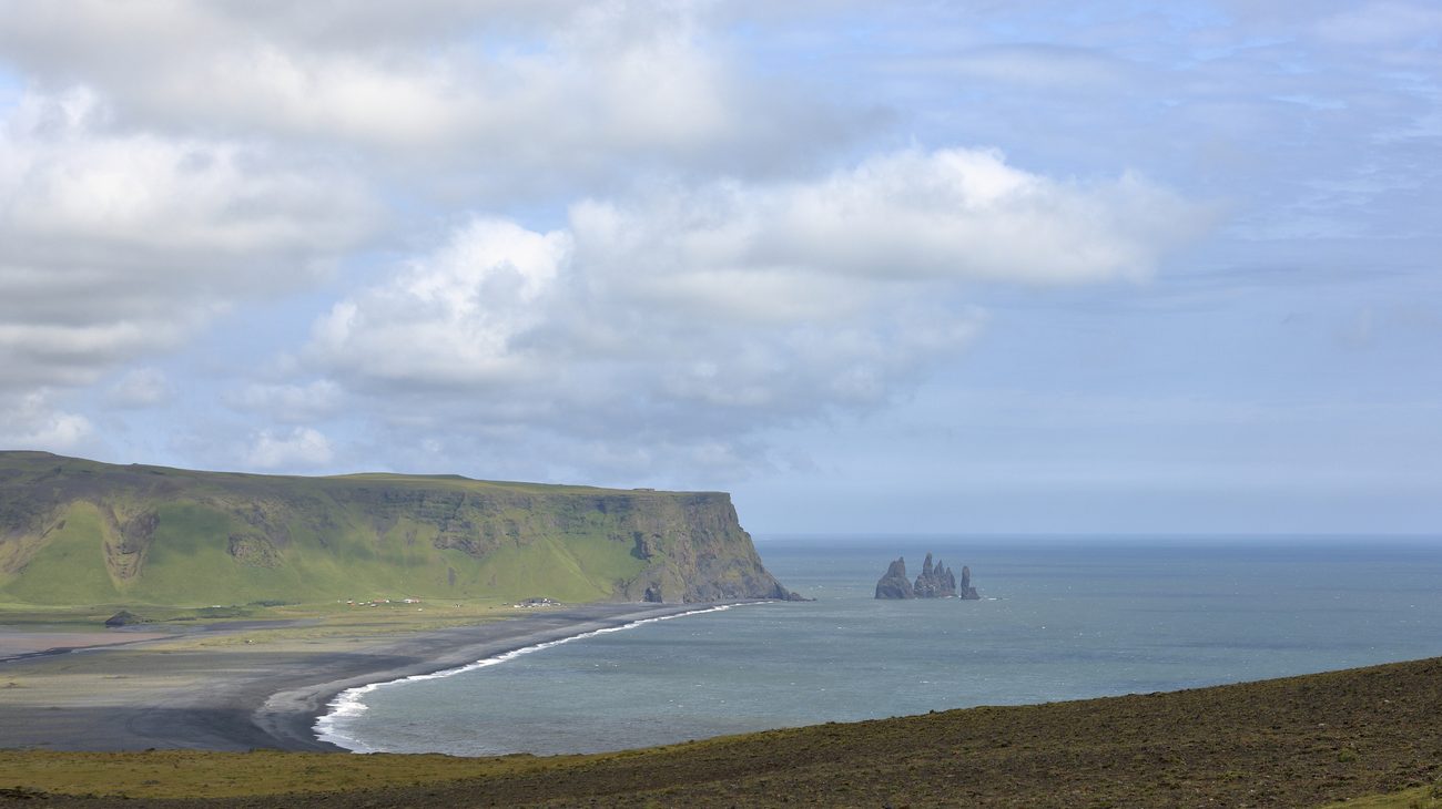
Just offshore rise the Reynisdrangar sea stacks—jagged basalt needles that, according to Icelandic folklore, were once petrified trolls caught in the dawn sunlight while trying to drag a three-masted ship to shore. Above the cliffs, thousands of Atlantic puffins nest in grassy burrows from May to August, swooping down toward the churning ocean.
- Quora Critical Warning (Sneaker Waves): Quora locals cannot stress this enough: Never turn your back on the ocean at Reynisfjara. The beach is world-infamous for lethal "sneaker waves"—rogue swells that surge unexpectedly far up the steeply sloped sand shelf, knocking tourists off their feet and dragging them into freezing, violently churning undertows. Always obey the digital warning light system at the parking lot.
3. Landmannalaugar & The Fjallabak Nature Reserve (Highlands)
Deep in the uninhabited southern Highlands, Landmannalaugar looks like a landscape painted in watercolors. Unlike the stark black-and-white palette of coastal Iceland, the volcanic mountains here are composed of rhyolite—a mineral-rich volcanic rock that glows in bizarre shades of mustard yellow, mint green, salmon pink, burnt orange, and deep turquoise.
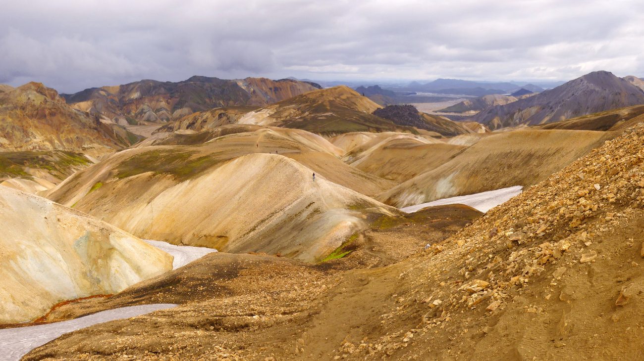
This is the northern trailhead of the legendary 34-mile Laugavegur Trail, one of National Geographic’s top treks in the world. After hiking past active fumaroles and steaming obsidian lava fields at the foot of Brennisteinsalda ("Sulfur Peak"), you can shed your hiking boots and soak in a natural thermal river where boiling subterranean water blends with cool mountain streams.
- Quora Traveler Wisdom: Landmannalaugar is accessible only in midsummer (typically late June through early September) via rough, unpaved Mountain "F-roads" (such as F208 or F225) that require a legal, high-clearance 4x4 vehicle with river-fording capabilities. If you do not have a 4x4, book a Highland Bus ticket from Reykjavik.
4. Kirkjufell & Kirkjufellsfoss (Snæfellsnes Peninsula)
Often nicknamed "Iceland in Miniature" because it contains glaciers, fjords, volcanoes, and black sand beaches on a single peninsula, Snæfellsnes is home to the country’s most photographed mountain: Kirkjufell ("Church Mountain").
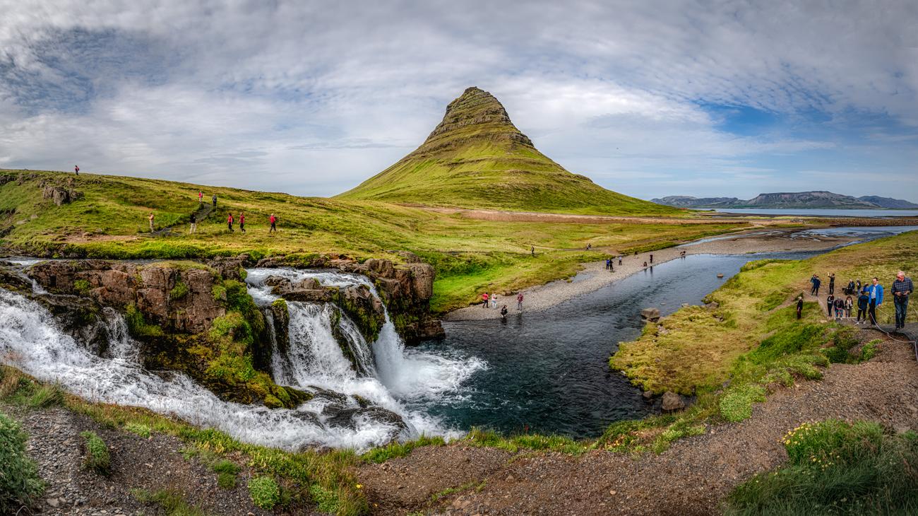
Rising 1,519 feet steeply out of the ocean near the fishing town of Grundarfjörður, its distinct arrowhead profile gained worldwide fame as the "Arrowhead Mountain" north of the Wall in HBO's Game of Thrones. Across the road, the multi-tiered waterfall Kirkjufellsfoss provides the classic vantage point, allowing photographers to frame the cascading glacial stream against the mountain's dramatic slopes.
- Quora Traveler Wisdom: In winter (October through March), Kirkjufell is arguably the premier spot in western Iceland to photograph the Northern Lights (Aurora Borealis) swirling across the night sky above the peak and reflecting in the icy lagoon below.
5. Skógafoss: The Thundering Giant of the South Coast
Cascading over a former sea cliff along the South Coast, Skógafoss is one of Iceland’s biggest and most classical waterfalls, dropping 197 feet with a consistent width of 82 feet. The volume of water crashing onto the rocky riverbed generates so much spray that on sunny days, brilliant single or double rainbows arch across the emerald gorge.
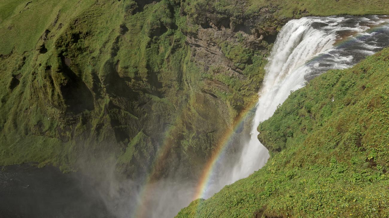
Unlike waterfalls cordoned off behind fences, you can walk directly up to the base of Skógafoss—just prepare to be completely drenched in glacial spray within seconds! To the right of the fall, a steep metal staircase of 527 steps climbs to an observation platform and marks the start of the Fimmvörðuháls Trail, which winds between two active glaciers (Eyjafjallajökull and Mýrdalsjökull) past 26 additional cascading waterfalls.
- Quora Traveler Wisdom: Combine Skógafoss with nearby Seljalandsfoss (where you can walk entirely behind the thundering water curtain) and the secret hidden canyon waterfall Gljufrabui, tucked inside a narrow cave just 500 meters down the trail.
6. Stuðlagil Canyon: The Basalt Column Wonder (East Iceland)
Hidden in the Jökuldalur valley in eastern Iceland, Stuðlagil Canyon boasts the largest collection of columnar basalt formations in Iceland, framing a striking turquoise-blue river. For decades, this natural wonder was completely submerged beneath a raging, silt-brown glacial river until the construction of the Kárahnjúkar hydroelectric plant in 2009 lowered the water level, revealing the towering vertical geometric rock cathedral to the world.
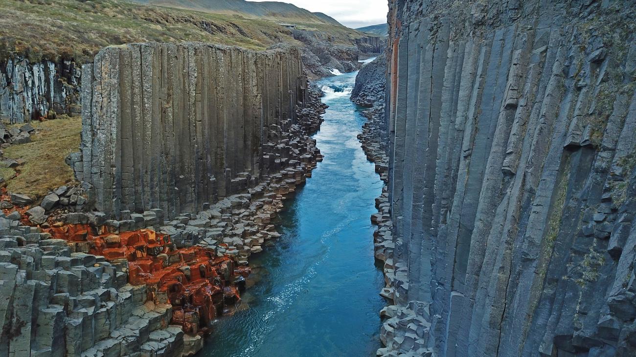
Walking along the eastern rim down onto the basalt basalt shelf feels like standing inside a prehistoric temple. The rock columns are so mathematically precise that it is hard to believe they were created purely by volcanic cooling.
- Quora Traveler Wisdom: There are two sides to Stuðlagil: the West Side (which has a viewing platform with metal steps, good for a quick look) and the East Side (which requires a 3-mile round-trip hike from the Klaustursel parking lot). Quora hikers urge taking the East Side—it is the only way to hike down directly into the canyon floor and touch the basalt pillars.
- Seasonal Note: In late August and spring, overflow from the reservoir can turn the river from crystalline turquoise to murky brown; visit in midsummer for the clearest turquoise water.
7. Vestrahorn & Stokksnes Peninsula: The Batman Mountain
Rising sheer out of black volcanic dunes and shallow tidal flats near Höfn, Vestrahorn is a jagged, ominous gabbro mountain that peaks at 1,490 feet. Its sharp, jagged twin silhouettes have earned it the nickname "The Batman Mountain."
At low tide, a thin film of seawater covers the black sand beach, creating a colossal, glass-like natural mirror that reflects the jagged mountain face and shifting Arctic clouds. Tucked into the dunes behind the beach sits a wooden replica of an authentic 9th-century Viking village, originally built as a movie set and now preserved for travelers.
- Quora Traveler Wisdom: Stokksnes is on private land, requiring a small entrance fee payable at the Viking Café. Quora photographers consider this one of the top three photography locations on the entire island, particularly during moody, stormy weather when mist wraps around the mountain's jagged spires.
8. The Golden Circle: Þingvellir, Geysir & Gullfoss
No guide to Iceland can ignore the classic Golden Circle, located just an hour east of Reykjavik. While popular, its geological and historical significance is monumental.
-
Þingvellir National Park: A UNESCO World Heritage site where you can literally walk between the exposed tectonic plates of North America and Eurasia in the Almannagjá rift valley. This is also where the world’s oldest parliament (the Althing) was established in 930 AD.
-
Geysir Geothermal Area: Home to the dormant Great Geysir (which gave all geysers their name) and Strokkur, which erupts a column of boiling water 60 to 100 feet into the air reliably every 6 to 10 minutes.
-
Gullfoss ("Golden Falls"): A colossal two-tiered waterfall where the Hvítá River plunges 105 feet into a rugged canyon, kicking up massive golden mist plumes.
-
Quora Traveler Wisdom: Because large tour buses arrive from Reykjavik between 10:00 AM and 3:00 PM, drive the Golden Circle in reverse or visit late in the evening during summer. Experiencing Strokkur erupting under the midnight sun with only five other people around is magical.
9. Lake Mývatn & Dimmuborgir Lava Fields (North Iceland)
Located along the volcanic rift zone in northeastern Iceland, the Lake Mývatn region is an otherworldly landscape of steaming geothermal vents, bubbling mud pools (Hverir), pseudo-craters, and bizarre volcanic geology.
Wander through Dimmuborgir ("Dark Castles"), a labyrinth of twisted volcanic rock pillars, collapsed lava tubes, and natural stone arches formed 2,300 years ago. Afterward, hike to the rim of Hverfjall, a massive, pitch-black tephra explosion crater measuring over half a mile wide. End your day soaking in the Mývatn Nature Baths, North Iceland's less crowded, natural blue geothermal lagoon.
- Quora Traveler Wisdom: Mývatn is named after the tiny midges (mý) that hatch in summer. While they don't bite like mosquitoes, they can swarm aggressively on windless days near the lake. Pack a cheap mesh head net in your daypack—it will save your sanity!
10. Dynjandi Waterfall & The Remote Westfjords
Tucked into the remote, deeply indented peninsula of the Westfjords, Dynjandi (also known as Fjallfoss) is widely regarded by Quora travelers as the most breathtaking waterfall in Iceland. Dropping 330 feet down a series of natural rock terraces, it fans out from 98 feet wide at the top to 196 feet at the base like an immense, flowing bridal veil.
As you hike up the trail from the fjord, you pass six smaller waterfalls cascading down the gorge before standing beneath Dynjandi’s thundering amphitheater. The Westfjords receive less than 10% of Iceland’s international visitors, offering empty coastal roads, geothermal hot pots overlooking fjords, and sheer bird cliffs at Látrabjarg where puffins sit calmly within arm's reach.
- Quora Traveler Wisdom: The roads in the Westfjords feature steep gravel passes and require slow, attentive driving. Allocate at least 2 to 3 days to explore the region properly, rather than attempting a hurried day trip.
11. Dettifoss: The Raw Power of Nature (Vatnajökull North)
Plunging 144 feet into the jagged Jökulsárgljúfur canyon in Vatnajökull National Park, Dettifoss is officially the most powerful waterfall in Europe by water volume, with over 130,000 gallons of gray-brown glacial meltwater roaring over its 330-foot-wide basalt lip every single second.
The sheer sensory experience is staggering. The ground literally vibrates beneath your hiking boots hundreds of yards before you reach the edge, and the roar drowns out all human conversation.
- Quora Traveler Wisdom: You can view Dettifoss from two sides: the West Bank (Road 862, paved, features accessible metal viewing platforms) and the East Bank (Road 864, unpaved gravel, open summer only). The East Bank lets you walk right to the precipice of the waterfall with zero barriers for a far raw, unobstructed view.
12. Askja Caldera & Víti Geothermal Crater (Central Highlands)
For the ultimate volcanic adventure, journey into the desolate moonscape of Askja, a 20-square-mile collapsed caldera in the Dyngjufjöll mountains where NASA astronauts Neil Armstrong and Buzz Aldrin trained in the 1960s to prepare for the Apollo moon landings.
Adjacent to the deep blue Lake Öskjuvatn sits Víti ("Hell"), an explosive geothermal crater formed in 1875 filled with warm, milky-teal mineral water. On calm summer days, adventurous hikers scramble down the steep, slippery clay embankment to swim in the geothermal crater surrounded by volcanic crater walls.
- Quora Traveler Wisdom: Reaching Askja requires an intensive 4x4 expedition across rough lava tracks and unbridged river crossings. Never attempt this alone without proper equipment, or book a guided super-jeep tour from Akureyri or Mývatn.
Iceland's 12 Wonders: Quora Quick-Reference Table
| Destination | Region | Main Appeal | Road Access | Quora Insider Advice |
|---|---|---|---|---|
| Jökulsárlón & Diamond Beach | South Coast | Icebergs floating to black sand | Route 1 (Paved) | Visit at sunrise; never step onto floating lagoon icebergs. |
| Reynisfjara Beach | South Coast | Hexagonal basalt columns, puffins | Route 1 (Paved) | Beware sneaker waves; never turn your back on the ocean. |
| Landmannalaugar | Highlands | Multi-colored rhyolite mountains, springs | F-Road (4x4 Only) | Soak in natural warm stream; hike Brennisteinsalda trail. |
| Kirkjufell | Snæfellsnes | Iconic arrowhead peak & waterfall | Paved Highway | Prime winter spot for Northern Lights photography. |
| Skógafoss | South Coast | 197-ft thundering waterfall, rainbows | Route 1 (Paved) | Walk behind neighboring Seljalandsfoss and visit Gljufrabui. |
| Stuðlagil Canyon | East Iceland | Deepest basalt column canyon | Gravel / Hike | Hike the East Side trail to touch the basalt columns. |
| Vestrahorn / Stokksnes | East Coast | Jagged mountain mirrored in black flats | Paved / Short gravel | Low tide creates a magical mirror reflection on wet sand. |
| Golden Circle | Southwest | Tectonic rift, geysers, Gullfoss | Paved Highway | Drive late afternoon to escape mass Reykjavik bus tours. |
| Lake Mývatn | North Iceland | Geothermal mud pots, lava castles | Route 1 (Paved) | Bring a mosquito/midge head net; soak in Mývatn Baths. |
| Dynjandi | Westfjords | Tiered bridal veil cascading waterfall | Gravel / Paved passes | Spend 2–3 days exploring the wild, empty Westfjords. |
| Dettifoss | North Iceland | Europe's most powerful waterfall | Paved (West) / Dirt (East) | East Bank (Road 864) provides rawest, fence-free views. |
| Askja & Víti Crater | Central Highlands | Moonscape caldera, geothermal swim | Extreme F-Road (4x4) | Super-jeep tour recommended; historic Apollo training site. |
4 Critical Rules for Iceland Travel in 2027
- Rent a Camper Van or 4x4 with Gravel Insurance: Standard car rental insurance in Iceland often excludes wind damage (doors blown off hinges by Arctic gale gusts) and ash/gravel damage. Always opt for comprehensive gravel protection, and hold vehicle doors firmly with two hands when opening them in high winds.
- Monitor Vedur.is and SafeTravel.is Daily: Icelandic weather can shift from clear sunshine to blinding 60-mph gale blizzards within an hour. Check the official meteorological forecast (Vedur.is) and road condition tracker (Road.is) every morning before driving.
- Respect Delicate Moss (Never Drive Off-Road): Driving off designated roads is strictly illegal in Iceland and carries thousands of dollars in fines. Subarctic moss takes hundreds of years to regenerate; tire ruts cause permanent, irreparable scars on the fragile volcanic tundra.
- Pack for All Four Seasons in One Day: Even in July, temperatures hover between 45°F and 55°F (7°C–13°C) with sudden sideways rain. Wear waterproof Gore-Tex outer shells, thermal merino wool underlayers, and sturdy ankle-height waterproof hiking boots.
Frequently Asked Questions (FAQ)
How many days are needed to drive the complete Ring Road?
To comfortably circumnavigate Iceland's 828-mile Ring Road (Route 1) without rushing, plan for a minimum of 8 to 10 days in summer. If you want to include detours into the Snæfellsnes Peninsula or the remote Westfjords, budget 12 to 14 days.
When is the best time to see the Northern Lights in Iceland?
The Northern Lights (Aurora Borealis) are visible from early September through mid-April, when Iceland experiences true night darkness. Peak aurora activity typically occurs around the autumn and spring equinoxes (September–October and February–March).
Can I drink the tap water in Iceland?
Yes! Icelandic tap water is among the purest in the world, filtered naturally through volcanic basalt rock aquifers. It is completely safe, clean, and delicious. Never waste money buying bottled plastic water in stores—just carry a reusable bottle and fill it from any tap.
Is Iceland too expensive for budget travelers?
Iceland is undeniably one of Europe's pricier destinations, primarily due to high food and lodging costs. You can save thousands of dollars by renting a camper van (combining transit and lodging), cooking meals bought at budget grocery chains like Bónus or Krónan, and taking advantage of the fact that all natural sights and national parks have free admission!
More Comprehensive Travel Guides & Road Trips:
- 15 Best Places to Visit in Alaska According to Quora: A Wilderness Guide
- 15 Best Places to Visit in Canada According to Quora: From Rockies to Secret Frontiers
- 15 Best Places to Visit in the USA for First-Time Travelers According to Quora
- 10 Best Great Lakes Circle Tour Stops Reddit Travelers Recommend in 2027
This article is for informational purposes. Flight routes, passenger regulations, visa rules, and transit advisories are subject to change by airlines and aviation authorities. Readers are advised to verify schedules and travel documentation with relevant carriers and border agencies before departure.
Related Stories
15 Best Places to Visit in India That International Travelers Should Know About
15 Best Places to Visit in Australia for an Unforgettable Holiday According to Quora