Florida Learjet 60 Crash in Palm Beach County: Travel Disruptions, Military Trail Closures & Investigation

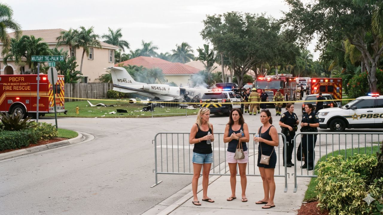
Before plunging into a residential corridor in Palm Beach County at a vertical descent rate exceeding 32,000 feet per minute, the flight crew of a private Learjet 60 calmly reported manageable icing to air traffic controllers. Minutes later, the Bahamas-bound twinjet slammed into the ground along Military Trail at approximately 12:50 p.m. Eastern Standard Time on Sunday, 1 November 2026, creating a deep impact crater, destroying underground water infrastructure, and triggering the urgent evacuation of approximately 600 residents from an adjacent mobile-home neighborhood. While all nine occupants aboard the private flight from Austin-Bergstrom International Airport perished—as confirmed by United States Transportation Secretary Sean Duffy—Florida Governor Ron DeSantis verified that zero ground fatalities occurred despite flaming wreckage scattering across roadways between Greenacres and Lake Worth Beach.
Disaster Along Military Trail: Emergency Response and Roadway Closures
The disaster unfolded rapidly along one of the primary north-south traffic arteries in central Palm Beach County. The aircraft came down near Military Trail between Cresthaven Boulevard and 10th Avenue North, an active corridor shared by residential neighborhoods, local storefronts, and utility corridors. Governor Ron DeSantis described the crash site during an emergency press conference on 1 November: "It was like a missile coming down, and a massive explosion, debris going everywhere." The heavy impact excavated a substantial crater adjacent to a mobile-home park, sending plumes of black smoke into the humid afternoon air and showering burning debris across traffic lanes.
Palm Beach County Commissioner Joel Flores confirmed that the crash inflicted widespread damage on surface roads and ruptured regional water distribution mains. Emergency response teams, including municipal firefighters and hazardous materials units, secured the crash perimeter and contained burning jet fuel. Because of fire hazards, severed utilities, and airborne debris, county authorities ordered the precautionary evacuation of approximately 600 residents from the adjacent neighborhood, relocating families into two designated emergency shelters supported by municipal transport.
The Palm Beach County Sheriff's Office immediately shut down both northbound and southbound lanes of Military Trail between Cresthaven Boulevard and 10th Avenue North. Officials have instructed motorists and commercial operators to avoid the corridor entirely while federal investigators sift through wreckage and utility crews repair subterranean water pipes. County traffic engineers established detours directing vehicles onto Haverhill Road and Kirk Road for north-south bypasses, alongside Purdy Lane and 10th Avenue North for east-west detours.
| Transport and Infrastructure Dimension | Official Emergency Status | Regional Travel Impact |
|---|---|---|
| Primary Roadway Closure | Military Trail (Northbound & Southbound) | Closed between Cresthaven Blvd & 10th Ave North |
| Designated North-South Detours | Haverhill Road and Kirk Road | Increased transit times near Greenacres |
| Designated East-West Detours | Purdy Lane and 10th Avenue North | Local arterial delays for residential traffic |
| Residential Neighborhood Evacuation | Approximately 600 residents displaced | Temporary housing provided at 2 county shelters |
| Municipal Infrastructure Damage | Substantial impact crater & ruptured water lines | Extensive roadway resurfacing & pipe restoration |
| Corridor Reopening Schedule | Indefinite pending NTSB on-site inspection | Travelers urged to check official county notices |
Cockpit Distress Sequence and Federal Investigation: NTSB and FAA Mobilize
The aircraft, a mid-size corporate Learjet 60 manufactured by Bombardier, departed Austin-Bergstrom International Airport in Texas on Sunday morning, carrying nine passengers and crew bound for North Eleuthera Airport in the Bahamas. According to air traffic control audio recordings reviewed by Reuters, the cockpit crew initially described regional atmospheric icing as manageable while encountering moderate turbulence, asking air traffic controllers for an alternative altitude with smoother conditions.
The flight environment deteriorated with terrifying speed. The cockpit broadcast an urgent Mayday call as the twinjet entered an initial descent of 10,000 feet per minute. Radar tracking subsequently recorded the descent rate steepening to 20,000 feet per minute. The pilots issued a dire transmission to controllers: "We're going to crash into the ground." Moments later, the cockpit reported a descent velocity of 22,000 feet per minute, with the final recorded words stating: "We're out of time." Independent flight-tracking platform Flightradar24 recorded vertical descent data that briefly topped 32,000 feet per minute before transponder signals ceased.
The National Transportation Safety Board dispatched a specialized go-team to lead the accident investigation, with technical support from the Federal Aviation Administration. Aircraft manufacturer Bombardier confirmed its full cooperation with investigators. The inquiry will examine radar parameters, engine components, airframe structural integrity, maintenance logs, and weather interactions to establish the exact sequence of events.
Severe thunderstorms formed across South Florida on Sunday afternoon. At 3:49 p.m. Eastern Time, the National Weather Service Miami issued flash flood and severe storm advisories for northeastern Palm Beach County, citing intense convective thunderstorms that dropped between 2.5 and 3.5 inches of rain. While atmospheric icing, severe wind shear, and microbursts remain subjects of technical evaluation, federal officials cautioned that preliminary cockpit remarks do not constitute definitive causes.
| General Aviation Safety Metric | FAA FY2023 Performance | FAA FY2024 Performance | Trend Analysis |
|---|---|---|---|
| Active US General Aviation Aircraft | Exceeds 275,000 aircraft | Exceeds 275,000 aircraft | Stable national fleet size |
| Annual Economic Contribution | Over $247 billion | Over $247 billion | Major national economic driver |
| Total Employment Supported | Approximately 1.2 million jobs | Approximately 1.2 million jobs | Broad workforce across maintenance and operations |
| Fatal Accident Rate per 100,000 Hours | 0.71 fatal accidents | 0.68 fatal accidents | Historic low recorded in FY2024 |
| Total Recorded Fatal Accidents | 206 accidents (est.) | 195 fatal accidents | Downward accident trend |
| Total Recorded Aviation Fatalities | 358 fatalities (est.) | 337 fatalities | Reduced annual fatality count |
The FAA 2025 General Aviation Safety Fact Sheet demonstrates that while private aviation achieved its lowest fatal accident rate in modern record-keeping during FY2024, unexpected high-altitude structural and meteorological emergencies demand exhaustive investigation.
What Makes Palm Beach County and the Bahamas Corridor Unique: Aviation Gateways and Coastal Contrasts
Palm Beach County is characterized by sharp contrasts between coastal resort enclaves and working inland neighborhoods. While oceanfront barriers host world-renowned luxury estates, inland districts such as Greenacres, Lake Worth Beach, and Palm Springs house essential workers, retirees, and mobile-home communities. Military Trail serves as the commercial backbone connecting these inland populations with schools, medical centers, and shopping plazas, making any prolonged closure a major disruption to community routines.
The flight path connecting Austin, Texas, with North Eleuthera Airport in the Bahamas highlights an exclusive private travel corridor. North Eleuthera serves as the primary air gateway for visitors heading to Harbour Island, celebrated for its historic Dunmore Town architecture and pink sand beaches. Private aviation allows travelers to bypass commercial flight transfers through Miami International Airport or Nassau Lynden Pindling International Airport, landing directly on Out Island airstrips.
Importantly for regional air travelers, Palm Beach International Airport (PBI), situated just miles north of the crash location along Southern Boulevard and Australian Avenue, maintains uninterrupted commercial flight operations. The crash occurred entirely within a suburban surface corridor, sparing airport runways, taxiways, and terminal facilities. Commercial passengers flying through PBI will experience normal flight schedules, although surface driving routes to terminal parking require extra travel time.
Visitor Insider Tips: Navigating Palm Beach Detours and Storm Resiliency
Travelers moving through Palm Beach County during active emergency closures and unpredictable weather should incorporate practical local transit strategies:
- Bypass Military Trail via Interstate 95 or Florida's Turnpike: To access Palm Beach International Airport or coastal resorts without delays, avoid central surface streets. Drivers traveling north or south should stay on Interstate 95 or Florida's Turnpike, exiting at Southern Boulevard (State Road 80) or Belvedere Road to enter airport gates directly.
- Monitor County Sheriff Traffic Alerts: Check live updates published by the Palm Beach County Sheriff's Office before setting out through Lake Worth Beach or Greenacres. Roadway access near Cresthaven Boulevard remains strictly cordoned off for emergency utility repairs and federal investigators.
- Exercise Extreme Caution During Sudden Downpours: South Florida convective storms can deposit 3 inches of rain in under an hour, overwhelming street storm drains along secondary arterials such as Kirk Road and Haverhill Road. Reduce vehicle speed, activate headlights, and never drive through standing floodwater accumulating in swales.
- Confirm Bahamas Charter Protocols with Fixed Base Operators: Travelers arranging private charter flights from South Florida to North Eleuthera should verify tail numbers, aircraft de-icing capabilities, and weather contingency plans directly with terminal fixed-base operators before departure.
- Discover Cultural Gems in Downtown Lake Worth Beach: If rerouted east toward the coast, spend time exploring the historic 1920s architecture, open-air cafes, and independent galleries along Lake Avenue and Lucerne Avenue, highlighted by Discover The Palm Beaches.
Cultural and Environmental Context: Community Resilience and Subtropical Weather Dynamics
The immediate evacuation of 600 residents from the Cresthaven neighborhood demonstrates the high community resilience and coordinated disaster preparedness found across South Florida municipalities. Manufactured-housing communities face distinct structural vulnerabilities, making rapid evacuation protocols essential when aviation emergencies or severe weather threats occur. Neighbors, faith organizations, and municipal volunteers mobilized quickly to ensure displaced residents received shelter, hot meals, and medical supplies.
From an environmental standpoint, aviation impacts in South Florida demand careful ecological management. The crash site sits atop shallow sandy soils that directly feed the regional Biscayne Aquifer, the primary freshwater source for millions of coastal residents. County environmental protection officers are deploying containment booms and soil extraction equipment to prevent unburned jet fuel from infiltrating municipal water tables.
Subtropical atmospheric dynamics also present ongoing challenges for aviation safety. During autumn, moisture-laden air masses rising from the Atlantic Ocean and the Gulf Stream meet northern frontal boundaries over South Florida. These conditions generate intense convective thunderstorms that reach altitudes above 40,000 feet, creating severe wind shear, rapid temperature drops, and sudden airframe icing. Understanding how private aircraft interact with these intense weather systems is essential to safeguarding future flight corridors connecting North America with Caribbean destinations.
FAQ: Palm Beach County Travel and Learjet 60 Investigation 2026
Did the Learjet 60 crash cause flight cancellations at Palm Beach International Airport?
No. Palm Beach International Airport (PBI) continues normal flight operations without interruption. The crash occurred along Military Trail in a residential neighborhood, several miles south of airport runways.
Which sections of Military Trail are closed to traffic?
Military Trail is closed in both directions between Cresthaven Boulevard and 10th Avenue North. Motorists should detour using Haverhill Road, Kirk Road, Purdy Lane, or 10th Avenue North.
How many people died in the Florida Learjet 60 crash?
All nine people aboard the private aircraft died. United States Transportation Secretary Sean Duffy and Governor Ron DeSantis confirmed there were no ground fatalities among local residents.
What federal agencies are investigating the crash?
The National Transportation Safety Board (NTSB) leads the investigation with technical support from the Federal Aviation Administration (FAA). Aircraft manufacturer Bombardier is also cooperating with investigators.
[As investigators sift through the scorched wreckage along Military Trail, Palm Beach County confronts a sobering reminder of aviation fragility beneath turbulent subtropical skies.]
Related Travel Guides
This article is for informational purposes. Flight routes, passenger regulations, visa rules, and transit advisories are subject to change by airlines and aviation authorities. Readers are advised to verify schedules and travel documentation with relevant carriers and border agencies before departure.
Related Stories

Middle East Flight Disruptions: 560 Delays and 95 Cancellations Hit Dubai, Jeddah, Cairo, and Regional Hubs

Asia Air Travel Hit by 193 Cancellations and 1,573 Delays: Mumbai, Jeddah, and Manila Lead Flight Gridlock