10 Best Great Lakes Circle Tour Stops Reddit Travelers Recommend in 2027: An Epic Odyssey Around North America's Inland Seas

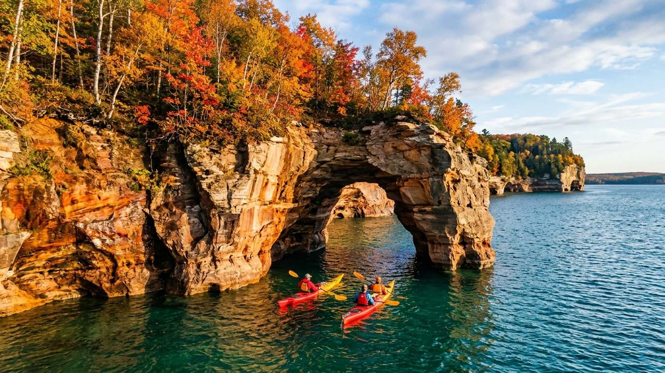
Sea kayakers paddling beneath the towering mineral-striped ramparts of Pictured Rocks National Lakeshore along Lake Superior.
There is a distinct moment when you first pull your car up to the rim of Lake Superior, kill the engine, and open the driver’s door. It does not feel like standing beside a lake. The air smells sharp, briny, and intensely cold, carried on a prevailing northwest gale that has traveled unimpeded across three hundred miles of open freshwater. Waves crash against dark volcanic basalt with a bass rumble you feel in your chest. The horizon stretches out dead flat and oceanic, with nothing between your boots and the subarctic Canadian wilderness.
The Great Lakes Circle Tour—whether you tackle the full 6,500-mile multi-lake transboundary loop or concentrate on the legendary 1,300-mile Lake Superior Circle Tour—is North America’s ultimate overlooked road trip. Across travel communities like r/roadtrip and r/CampAndHikeMichigan, seasoned overlanders continually warn novices: do not underestimate the scale of these inland seas. They possess their own unpredictable microclimates, historic shipwrecks, Caribbean-clear turquoise waters, and ancient boreal forests that rival anything on the Pacific coast.
Having navigated these coastal highways across changing seasons, here are the 10 best Great Lakes Circle Tour stops Reddit travelers swear by for 2027, featuring first-hand route advice, hidden turnouts, and vital navigational warnings.
1. Pictured Rocks National Lakeshore, Michigan: Sandstone Battlements and Turquoise Shallows
Sea kayakers navigating the natural vaulted archways and mineral-stained ramparts of Pictured Rocks in peak autumn.
Stretching for forty miles along the rugged southern shore of Lake Superior between Munising and Grand Marais, Pictured Rocks National Lakeshore is the undisputed crown jewel of the Lake Superior Circle Tour. Sandstone cliffs soaring two hundred feet above the water are painted in vibrant vertical bands of ochre, copper, green, and iron red—the result of mineral-rich groundwater weeping through porous rock faces over thousands of years.
The most humbling way to experience Pictured Rocks is from the waterline. Paddling a sea kayak beneath the colossal overhang of Lovers Leap or gliding over submerged golden sandstone reefs through water so clear you can count pebbles thirty feet down feels otherworldly. If you prefer to keep your boots dry, the 10-mile Chapel Loop trail hugs the cliff edges through old-growth sugar maple forests, leading to Chapel Rock—a solitary sandstone pillar anchored by the sprawling, exposed roots of an ancient white pine.
- The Traveler's Route: Base yourself in the small harbor village of Munising. Book a sunset boat cruise or guided tandem sea kayak excursion, and pack warm thermal layers regardless of the forecast—the surface temperature of Lake Superior rarely exceeds 55°F even in mid-August.
- Reddit Traveler Consensus: On r/roadtrip, community members universally advise against renting recreational sit-on-top kayaks for Lake Superior. Sudden wind shifts can whip up six-foot swells within twenty minutes; always go with an experienced outfitter equipped with true sea kayaks, spray skirts, and VHF radios.
2. Split Rock Lighthouse & Minnesota's North Shore: Basalt Cliffs and Maritime History
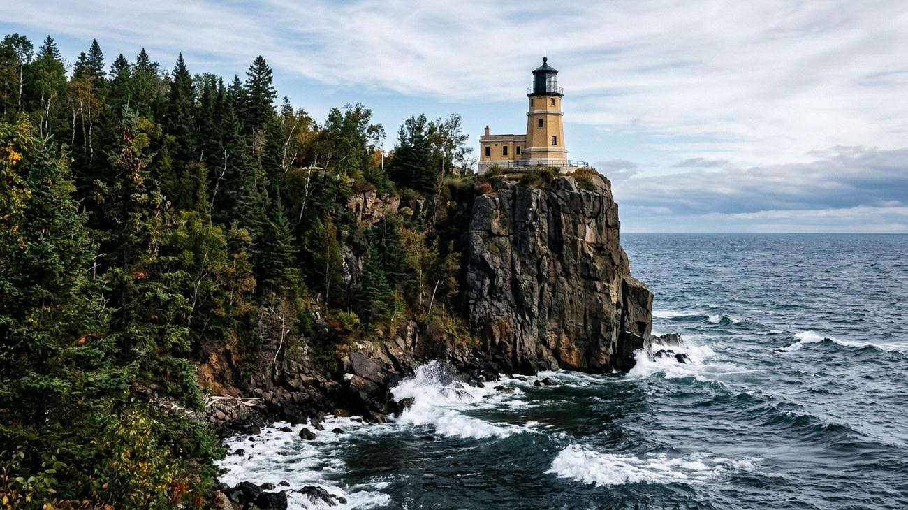 Split Rock Lighthouse standing sentinel atop sheer volcanic cliffs on Minnesota's rugged North Shore.
Driving north out of Duluth along Minnesota’s scenic Highway 61, the highway clings to the ancient Sawtooth Mountains, tracing the rocky rim of western Lake Superior. At mile marker 46 sits Split Rock Lighthouse, perhaps the most dramatically sited navigational beacon on the continent.
Built in response to the devastating Mataafa Storm of 1905, which battered or sank twenty-nine vessels in a single blinding blizzard, the octagonal yellow-brick lighthouse perches precariously atop a 130-foot cliff of dark, jagged anorthosite basalt. Standing on the pebble beach of Pebble Beach Cove looking upward as whitecaps smash against the cliff base gives you an immediate, visceral respect for the maritime perils of the Great Lakes.
- The Traveler's Route: Continue driving north along Highway 61 to explore the cascading waterfalls of Gooseberry Falls State Park and hike the sheer pink-rhyolite headlands at Palisade Head.
- The Local Bite: Stop in Two Harbors or Grand Marais for freshly smoked Lake Superior cisco and brown sugar whitefish pulled from commercial nets that morning.
- Reddit Traveler Consensus: Redditors emphasize traveling North-to-South if you want to stay in the water-facing lane, but note that dawn is the magic hour at Split Rock when morning light illuminates the cliff face and offshore fog rolls across the water.
3. Mackinac Island & The Straits of Mackinac: Victorian Elegance Where Lakes Collide
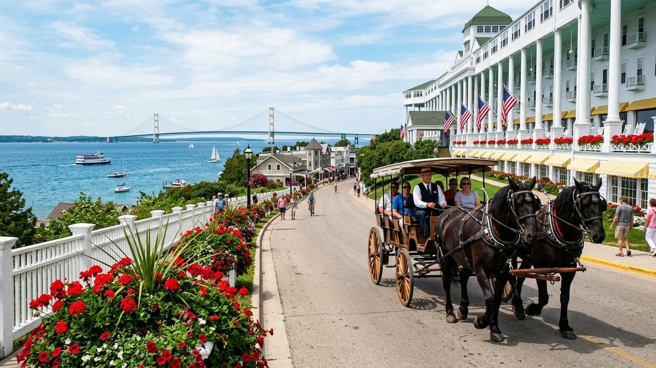 A traditional horse-drawn carriage trotting past the Grand Hotel colonnade with the Straits of Mackinac sparkling in the background.
Where Lake Michigan squeezes eastward into Lake Huron beneath the five-mile suspension spans of the legendary Mackinac Bridge, time slips backward by a century. Taking the ferry across to Mackinac Island requires leaving your vehicle behind on the mainland; motor vehicles have been strictly outlawed here since 1898.
Stepping onto the ferry docks, the sensory transition is immediate: the smell of cedar woodsmoke, fresh fudge cooking in copper kettles, the rhythmic clatter of draft horse hooves on asphalt, and the constant breeze rolling off the Straits. The island is circled by M-185, the only state highway in the United States where cars are entirely prohibited. Rent a single-speed cruiser bicycle and ride the flat, paved 8.2-mile coastal perimeter, stopping to explore natural limestone arches like Arch Rock and quiet pebble beaches strewn with ancient coral fossils.
- The Traveler's Route: Spend an afternoon walking the 660-foot covered front porch of the iconic Grand Hotel, sipping a gin and tonic while watching massive 1,000-foot Great Lakes freighters steam through the narrow channel beneath the Mackinac Bridge.
- Reddit Traveler Consensus: To avoid the day-tripper ferry crowds, Reddit contributors strongly suggest staying overnight on the island. After the last 7:00 PM ferry departs for Mackinaw City and St. Ignace, the island falls into peaceful, lamp-lit serenity.
4. Sleeping Bear Dunes National Lakeshore: 450-Foot Sand Bluffs and Caribbean Water
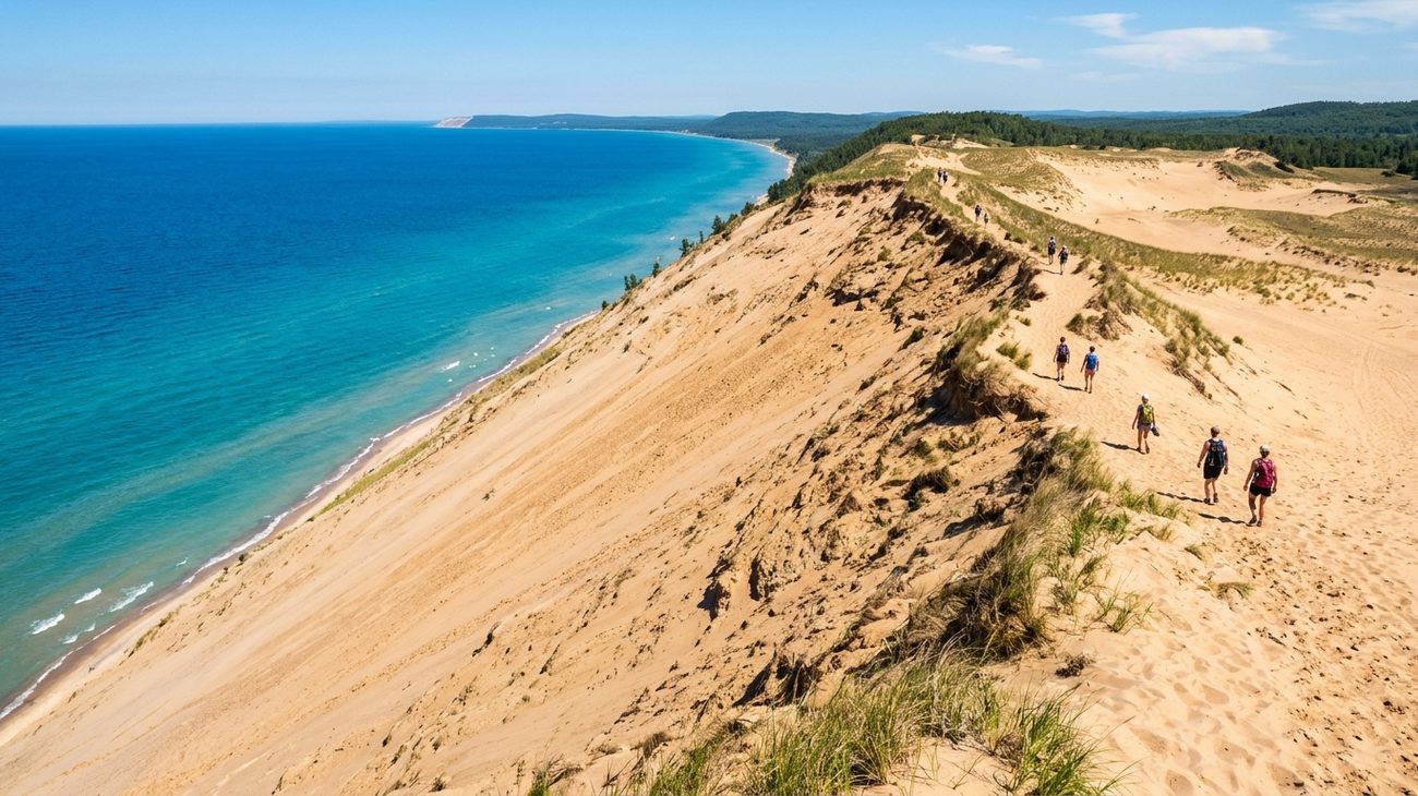 Standing along the towering knife-edge crest of Sleeping Bear Dunes as golden sand plunges 450 feet into Lake Michigan.
Located on the northwest shoulder of Michigan’s Lower Peninsula along Highway 22, Sleeping Bear Dunes National Lakeshore frequently shocks first-time visitors who assume the Midwest is devoid of dramatic topography. Here, colossal mountains of pale glacial sand rise hundreds of feet above Lake Michigan, crowned by marram grass and ancient ghost forests smothered by shifting sands.
Driving the 7.4-mile Pierce Stocking Scenic Drive brings you to Overlook #9, where the dune drops at an unnerving 33-degree angle straight down 450 vertical feet into water so brilliantly layered in aquamarine, cerulean, and royal blue that it mimics the Caribbean basin. Sitting on the dune crest listening to the whispering wind while offshore freighter horns echo in the distance is an experience etched permanently into your memory.
- The Traveler's Route: After hiking the challenging 3.5-mile Dunes Trail out to the open lake shore, drive fifteen minutes into the historic harbor town of Leland to visit Fishtown—a working 19th-century commercial fishing village of weathered shanty docks, smokehouses, and charter boats.
- Reddit Traveler Consensus: Heed the famous national park warning sign at the Lake Michigan overlook: Do not run down the dune unless you are prepared to spend two grueling hours climbing back up. Park rangers rescue dozens of dehydrated visitors every summer, and calling search-and-rescue comes with a hefty financial recovery fee.
5. Apostle Islands National Lakeshore, Wisconsin: Sea Caves, Red Sandstone Arches, and Solitude
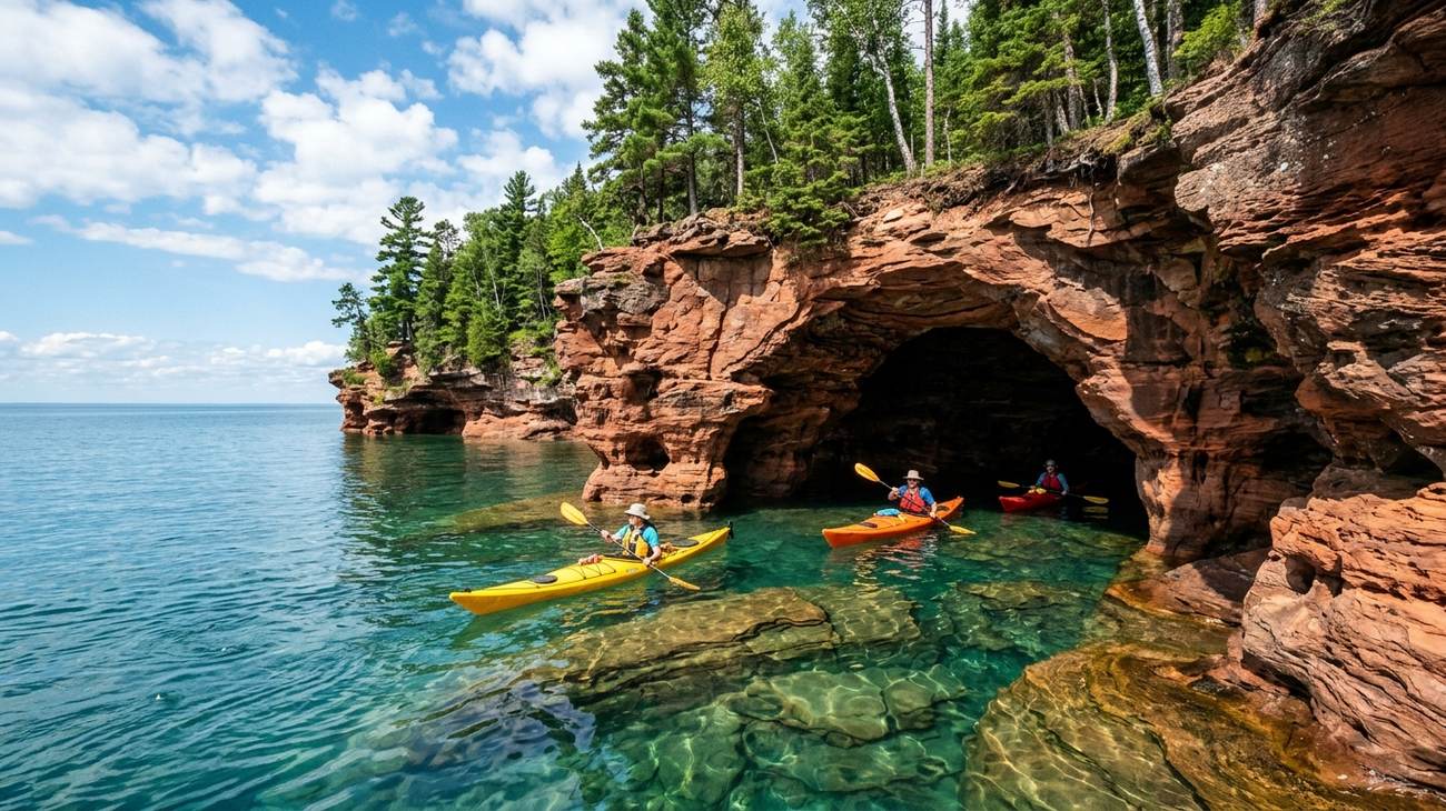 Sea kayakers navigating the vaulted sea chambers of Apostle Islands National Lakeshore near Bayfield, Wisconsin.
Clustered off the northernmost tip of Wisconsin’s Bayfield Peninsula, the Apostle Islands comprise twenty-one wilderness islands scattered across the western expanses of Lake Superior. Centuries of relentless wave action and winter freeze-thaw cycles have carved the vibrant Precambrian sandstone shoreline into labyrinthine networks of vaulted sea caves, hollow chambers, and stone arches.
During July and August, the water conditions inside the Mawikwe Bay sea caves are calm enough for guided sea kayaks to slip inside the shadowy chambers, where every drop of water falling from the ceiling reverberates like a cathedral bell. The surrounding waters house the largest collection of historic lighthouses anywhere in the National Park System, standing atop windswept sand spits and rocky bluffs.
- The Traveler's Route: Base your explorations in the picturesque maritime town of Bayfield. Board an excursion vessel or take the passenger ferry across to Madeline Island, renting a scooter to explore the red-clay cliffs and pine forests of Big Bay State Park.
- Reddit Traveler Consensus: If traveling in late winter or early spring during polar vortex years, check the National Park Service status page for the rare opening of the Ice Caves—when Lake Superior freezes thick enough for travelers to walk across the lake ice directly into frozen caverns draped in colossal icicles.
6. Bruce Peninsula National Park & The Grotto, Ontario: Georgian Bay Limestone Fjord
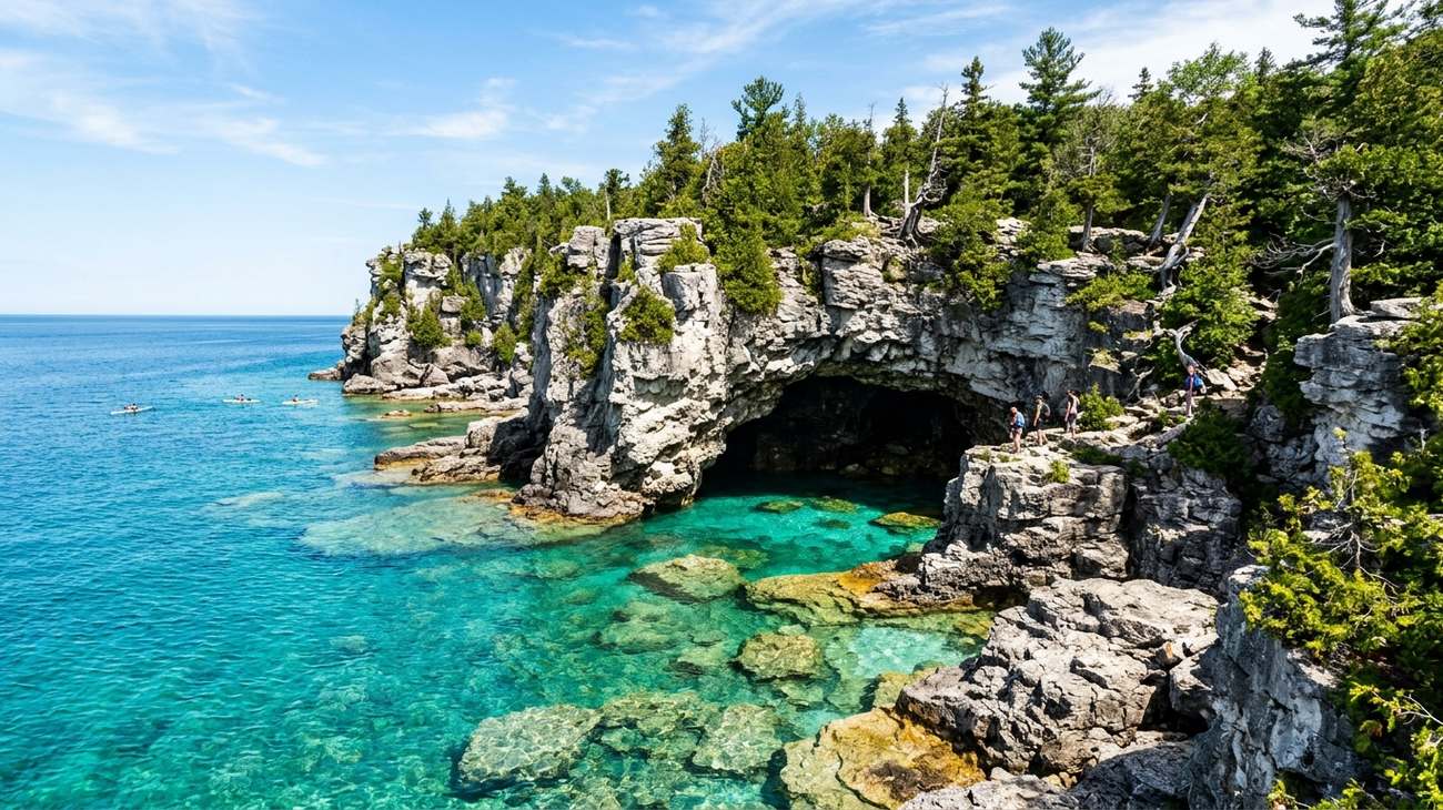 The natural limestone sea cavern of The Grotto at Bruce Peninsula National Park, glowing with transparent turquoise water.
For road trippers undertaking the full international Great Lakes loop, crossing into Ontario to traverse the Bruce Peninsula reveals an entirely different geological character. Dividing Lake Huron from the sheltered expanse of Georgian Bay, this jagged finger of the Niagara Escarpment features towering white dolomite limestone cliffs, ancient thousand-year-old stunted eastern white cedars, and water with optical clarity that rivals the Mediterranean.
The centerpiece of the park is The Grotto—a colossal natural sea cave carved into the limestone cliffs of Georgian Bay. Sunlight filtering through an underwater opening illuminates the cave pool in an eerie, luminous electric turquoise. Hiking the rugged Bruce Trail along the cliff tops delivers jaw-dropping views over deep underwater boulder fields that drop precipitously into the cobalt abyss.
- The Traveler's Route: From the harbor town of Tobermory, take a glass-bottom boat tour out to Fathom Five National Marine Park to view well-preserved 19th-century wooden schooner shipwrecks resting beneath twenty feet of crystal-clear water before visiting the towering limestone pillars of Flowerpot Island.
- Reddit Traveler Consensus: Parks Canada strictly enforces mandatory timed-entry parking permits for The Grotto during summer and autumn. On r/ontario and r/roadtrip, travelers stress booking your four-hour parking reservation the minute the portal opens in spring, or you will be turned away at the highway gate.
7. Door County Peninsula, Wisconsin: Fish Boils, Lighthouses, and Cherry Orchards
Projecting seventy miles out between Green Bay and Lake Michigan, Wisconsin’s Door County is often called the "Cape Cod of the Midwest." With three hundred miles of shoreline, five state parks, and eleven historic lighthouses, it balances coastal outdoor adventure with charming culinary traditions.
A drive up State Highway 42 leads through postcard-perfect harbor villages like Egg Harbor, Fish Creek, and Ephraim, where white-steeple churches and Scandinavian-inspired wooden docks overlook sheltered bays. The western coast boasts dramatic limestone bluffs at Peninsula State Park, while the eastern lake-facing shore features quiet sandy beaches and the wave-lashed gravel causeway leading out to the Cana Island Lighthouse.
- The Cultural Must-Do: Attend a traditional Door County Fish Boil at an establishment like the Old Post Office Restaurant in Ephraim or White Gull Inn in Fish Creek. Watching the boil-master toss fuel oil onto the fire pit, triggering a spectacular thirty-foot fireball that boils over the outdoor kettle of Lake Michigan whitefish and red potatoes, is a time-honored maritime ritual.
- Reddit Traveler Consensus: Don’t stop at the end of Highway 42. Drive all the way to Northport Pier and take the Washington Island Ferry across the treacherous strait historically known as Porte des Morts (Death’s Door) to visit Schoolhouse Beach, one of only a handful of limestone pebble beaches in the world.
8. Tahquamenon Falls & Whitefish Point: The Amber Falls and Shipwreck Coast
Deep in the eastern Upper Peninsula of Michigan, the Tahquamenon River flows through vast cedar swamps and hemlock forests before plunging over an upper sandstone ledge nearly two hundred feet wide and fifty feet tall. The Upper Tahquamenon Falls is the second-largest waterfall east of the Mississippi River by volume, characterized by its distinctive golden-amber, root-beer color—the natural result of cedar and hemlock tannins leaching from the forested watershed.
Continuing twenty miles north out to the desolate, wave-swept spit of Whitefish Point brings you to the graveyard of the Great Lakes. Lake Superior’s deepest waters narrow into a funnel here, and the waters offshore hold more than two hundred historic shipwrecks, including the ill-fated SS Edmund Fitzgerald, which went down seventeen miles northwest of the point in a ferocious November 1975 hurricane.
- The Traveler's Route: Visit the Great Lakes Shipwreck Museum at Whitefish Point to view the salvaged 200-pound bronze bell of the Edmund Fitzgerald, and walk the cold gravel beach searching for Lake Superior agates among millions of smooth stones.
- Reddit Traveler Consensus: Visit in mid-to-late September. The contrast between the roaring golden-amber waterfall and the brilliant scarlet and orange sugar maple canopy surrounding the gorge is breathtaking, and the summer black fly swarms have completely died off.
9. Lake Superior Provincial Park, Ontario: Agawa Rock and Canadian Shield Wilderness
Driving the northern arc of the Lake Superior Circle Tour along Ontario’s Highway 17 (the Trans-Canada Highway) between Sault Ste. Marie and Wawa leads into the untamed wilderness of the Canadian Shield. In Lake Superior Provincial Park, billion-year-old pink granite cliffs plunge directly into the dark, freezing waters of the lake, flanked by dense spruce, birch, and fir forests.
The park’s most revered cultural site is Agawa Rock. A rugged trail leads down through a narrow stone cleft to an open granite ledge sloping directly into Lake Superior. Here, painted onto the sheer rock face with red ochre and animal fat, are thirty-five ancient Ojibwe pictographs depicting canoes, woodland caribou, and Mishipeshu—the horned Great Lynx of the underworld who rules the treacherous waves of Lake Superior.
- The Traveler's Route: Pull off at Old Woman Bay, where a towering 400-foot granite cliff forms the profile of a woman’s face gazing out across a vast crescent of driftwood-strewn sand.
- Reddit Traveler Consensus: The granite ledge at Agawa Rock is completely open to the lake with only a safety rope anchored into the stone. Never attempt to walk the ledge when waves are crashing or when the rock is damp; rogue Lake Superior swells can easily sweep travelers off the slick stone into deep, freezing water.
10. Presque Isle State Park, Pennsylvania: Sandy Spits and Freshwater Surf on Lake Erie
While the Upper Lakes boast rugged wilderness and rocky bluffs, Lake Erie provides a surprisingly tropical coastal aesthetic at Presque Isle State Park in northwestern Pennsylvania. This 3,200-acre recurved sand spit curves into Lake Erie, creating thirteen miles of natural sandy beaches, protected interior lagoons, and dense coastal forests.
Presque Isle is a premier migration corridor for over three hundred species of birds and offers the warmest swimming waters on the Great Lakes during July and August. Rent a bicycle or rollerblades to cruise the 13.5-mile Karl Boyes Multi-Purpose Trail, ending your day at Sunset Point watching the orange sun drop into Lake Erie behind the historic 1872 Presque Isle Lighthouse.
- The Traveler's Route: Explore the tranquil interior waterways of the lagoons by renting a canoe or stand-up paddleboard from the marina, drifting through fields of blooming American lotus water lilies.
- Reddit Traveler Consensus: Combine Presque Isle with a visit to the Erie Maritime Museum downtown to learn about Oliver Hazard Perry’s famous victory in the Battle of Lake Erie during the War of 1812.
Great Lakes Circle Tour: Route Comparison & Planning Guide
| Stop Name | Primary Lake | Recommended Duration | Best Travel Window | Key Highlight | Reddit Traveler Pro-Tip |
|---|---|---|---|---|---|
| Pictured Rocks | Lake Superior | 2–3 days | July to early October | Sea caves, Chapel Rock | Avoid sit-on-top kayaks; hire certified sea kayak guides with spray skirts. |
| Split Rock Lighthouse | Lake Superior | 1–2 days | June to October | 130-ft basalt cliff, foghorn | Arrive at dawn for golden cliffside lighting and fewer crowds. |
| Mackinac Island | Huron & Michigan | 2 days (overnight) | May to October | Car-free streets, M-185 bike loop | Stay overnight after the last ferry leaves to experience quiet charm. |
| Sleeping Bear Dunes | Lake Michigan | 2 days | June to September | 450-ft sand bluff, turquoise lake | Do not run down the dune overlook; climbing back up takes two brutal hours. |
| Apostle Islands | Lake Superior | 2–3 days | July to August | Sandstone sea caves, lighthouses | Visit in winter for rare ice cave access when lake ice freezes solid. |
| Bruce Peninsula | Huron (Georgian Bay) | 2–3 days | July to September | The Grotto, white limestone cliffs | Book your 4-hour parking pass online weeks in advance via Parks Canada. |
| Door County | Lake Michigan | 2–3 days | May to October | Scandinavian fish boil, Cana Island | Take the ferry to Washington Island to walk smooth limestone pebbles. |
| Tahquamenon Falls | Lake Superior | 1–2 days | September to October | 200-ft wide amber falls, museum | Pair with Whitefish Point Shipwreck Museum; peak foliage in late Sept. |
| Lake Superior PP | Lake Superior | 2 days | July to September | Agawa Rock Ojibwe pictographs | Never walk the pictograph ledge in high surf or damp weather. |
| Presque Isle | Lake Erie | 1–2 days | June to August | 13 miles of sandy beaches, bluffs | Rent a canoe to paddle through blooming interior lagoon water lilies. |
Essential Reddit Wisdom for Circling the Great Lakes in 2027
1. The Transboundary Border Requirement
Completing the true Lake Superior Circle Tour or Lake Huron Loop requires crossing between the United States and Canada (via Sault Ste. Marie, the Bluewater Bridge in Port Huron, or the Ambassador Bridge in Detroit). Always ensure your passport or enhanced driver’s license is valid for at least six months, and check Canadian border rules regarding vehicle entry and pet documentation.
2. The Black Fly and Mosquito Window
June in the Upper Peninsula and Northern Ontario brings notorious black fly and mosquito hatches in forested marshlands. If you are sensitive to biting bugs, plan your Circle Tour between mid-July and early October, when insects subside and fall colors transform the hardwood shorelines into ribbons of gold and scarlet.
3. Pacing and Gasoline Availability
Around Lake Superior, particularly between Wawa and Marathon in Ontario or along Michigan’s M-28, towns are spaced fifty to seventy miles apart. Cellular coverage frequently drops to zero for long stretches through boreal forests. Never pass a fuel pump when your tank drops below a quarter, carry a physical highway atlas, and download offline navigation maps before departing Duluth, Marquette, or Sault Ste. Marie.
Frequently Asked Questions About the Great Lakes Circle Tour
How long does it take to drive around Lake Superior?
The standard 1,300-mile Lake Superior Circle Tour requires a minimum of seven to ten days to experience comfortably. This pacing allows for daily drives of 150 to 200 miles with ample time for hiking cliff trails, taking sea kayak excursions, and visiting historic lighthouses.
What is the most scenic stretch of the Great Lakes?
While every lake has breathtaking sections, the Lake Superior coastline—specifically the corridor spanning Minnesota’s North Shore, Michigan’s Pictured Rocks, and Ontario’s Lake Superior Provincial Park—is universally acclaimed as the most dramatic due to its towering basalt and sandstone cliffs.
Can you swim in the Great Lakes during the road trip?
Yes, but surface temperatures vary drastically. Lake Erie and southern Lake Michigan reach comfortable swimming temperatures (70–75°F) in July and August. Conversely, Lake Superior rarely climbs above 55–60°F in open waters, making swimming an invigorating, short polar plunge suitable only on hot, calm summer afternoons.
Do I need a four-wheel drive vehicle for the Circle Tour?
No. The primary Great Lakes Circle Tour routes (including US-2, US-41, MN-61, and Ontario Hwy 17) are well-maintained, fully paved two-lane federal and provincial highways easily navigable in any standard passenger sedan or crossover.
Fill the gas tank, pack your passport, and prepare for open horizons that will forever redefine your idea of the American heartland.
This article is for informational purposes. Flight routes, passenger regulations, visa rules, and transit advisories are subject to change by airlines and aviation authorities. Readers are advised to verify schedules and travel documentation with relevant carriers and border agencies before departure.
Related Stories
10 Best Keweenaw Peninsula Scenic Drives Reddit Travelers Recommend in 2027: A Highway Guide to Michigan's Copper Country
10 Best Route 66 Hidden Roadside Attractions Reddit Travelers Recommend in 2027