
Greenland's Ilulissat Icefjord Balances Direct Transatlantic Flights and Fragile Arctic Trails: Trail Counters and Conservation Analysis

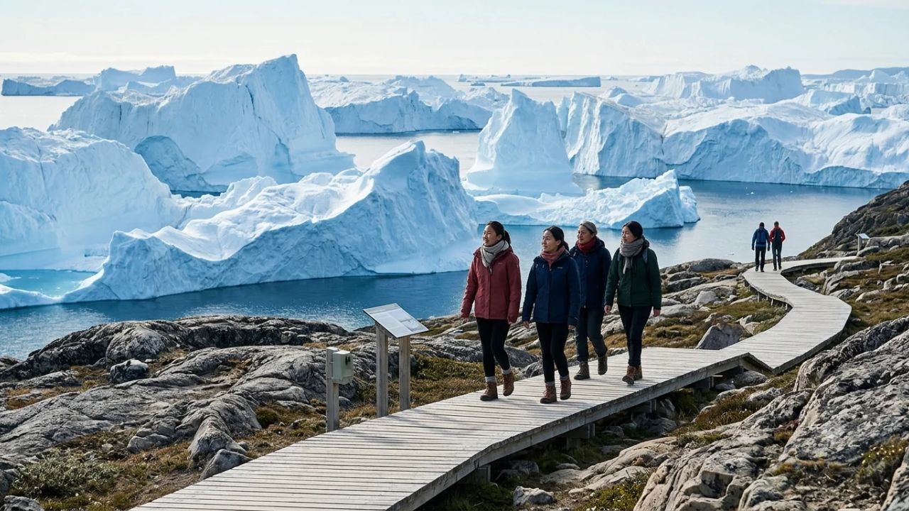
With the opening of Ilulissat’s new international airport and the launch of direct long-haul flights from Copenhagen and Iceland, Greenland’s premier UNESCO World Heritage site is deploying an automated trail-counter network to protect fragile Arctic ecosystems from visitor overcrowding.
Inaugurated on October 29, 2026, Ilulissat's 2,200-meter international runway eliminates the decades-old requirement for travelers to transfer through small regional turboprops at Kangerlussuaq. Ahead of the first full summer of direct transatlantic air services in 2027—featuring up to six weekly Air Greenland rotations from Copenhagen and three weekly Icelandair flights from Keflavík—the Ilulissat Icefjord Office (Ilulissat Isfjordskontor) is utilizing an array of four electronic trail sensors to establish an empirical baseline of pedestrian movement.
The data reveals that managing Arctic tourism carrying capacity depends far more on peak-hour pedestrian surges than annual headline totals. As Avannaata Municipality reinvests funds from its seasonal €10 environmental visitor fee into elevated timber boardwalks and ranger supervision, local authorities are testing whether advanced sensor analytics can safeguard Sermeq Kujalleq’s calving glacier basin without compromising the remote wilderness experience that draws international travelers to Disko Bay.
ILULISSAT ICEFJORD VISITOR MONITORING & INFRASTRUCTURE BASELINE
| Monitoring Metric | Recorded Data / Baseline Standard | Strategic Environmental Context |
|---|---|---|
| UNESCO Inscription | Inscribed 2004 (Protected 2003) | Kangia Icefjord & Sermeq Kujalleq |
| Trail Counter Network | 4 Automated Bidirectional Sensors | Completed August 2024; pre-airport |
| Boardwalk Traffic | 52,146 passages (2024 both ways) | ~36,000 unique walkers in 2025 |
| Peak Day Record | 16 June 2024: 1,188 total passages | 577 outbound / 611 return passages |
| New Airport Runway | 2,200 meters (Opened Oct 29, 2026) | Direct widebody/narrowbody service |
| 2027 Flight Schedule | 6x weekly CPH; 3x weekly KEF | First full direct summer season |
| Cruise Passenger Flow | 10,931 passengers (2025 season) | -23% from 14,165 passengers in 2024 |
| National Tourism GDP | DKK 1.741B spend; 4.9% of GDP | Visit Greenland Satellite Account |
| Environmental Site Fee | €10 per visitor (June 1–Oct 31) | Reinvested into boardwalk & rangers |
The Trail Sensor Network: Establishing a Pre-Expansion Baseline
To evaluate the true environmental impact of direct international aviation, the Ilulissat Icefjord Office completed the installation of four automated pedestrian sensors between June and August 2024. Positioned strategically across the trailheads of the protected area, these passive infrared sensors record passage counts, directional movement, and time stamps 24 hours a day.
ILULISSAT ICEFJORD TRAIL SENSOR LOCATIONS & MONITORING SCOPE
| Entity / Route | Metrics | Operational Status |
|---|---|---|
| Sensor Location | Route Category & Distance | Environmental Monitoring Focus |
| Sermermiut Boardwalk | Easiest Route (1.3 km each way) | Measures high-density family & |
| Starts at Icefjord Centre | cruise shore excursion traffic | |
| Holms Bakke | Red Route (Moderate terrain) | Monitors cultural viewing peaks and |
| Historic sun-welcoming viewpoint | elevation trail soil displacement | |
| Old Cemetery Headland | Yellow Route (2.7 km coastal loop) | Tracks coastal bluff foot traffic |
| Skirts Disko Bay icebergs | and heritage graveyard preservation | |
| Gorge Entrance | Blue Route (6.9 km backcountry) | Records long-distance trekkers |
| (Kløften) | Traverses rocky interior passes | entering wilderness interior zones |
1. Sermermiut Boardwalk: The Primary Pressure Point
The 1.3-kilometer wooden boardwalk leading from the Kangiata Illorsua (Icefjord Centre) through the Sermermiut valley to the icefjord viewing platform represents the primary thoroughfare for visitors.
On June 16, 2024, the sensor logged 577 outbound passages and 611 return passages, representing the single busiest day in the municipal register with 1,188 total daily movements. Across the entire 2024 recording window, the boardwalk recorded 52,146 total bidirectional passages.
The directional distinction is critical when interpreting year-on-year trends:
- In 2024, the reported figure of 52,146 reflected every sensor trigger, meaning an individual walking out to the icebergs and returning along the same path was tallied twice.
- In 2025, the Icefjord Office refined its reporting methodology, documenting approximately 36,000 unique individuals walking toward Sermermiut.
- For municipal managers, maintaining consistent directional filters is essential to avoid artificially inflating visitor counts as direct flights ramp up.
2. The Dispersal Routes: Red, Yellow, and Blue
While the boardwalk absorbs the vast majority of casual walkers, the remaining three sensor locations provide vital indicators of trail displacement:
- Red Route to Holms Bakke: Tracks hikers climbing the rocky granite knoll where locals traditionally gather on January 13 to celebrate the sun’s return above the horizon following the polar night.
- Yellow Route via the Old Cemetery: Monitors walkers navigating the rugged cliff paths south of town, where coastal erosion and unstable frost-shattered rocks require ongoing safety assessments.
- Blue Route Gorge Entrance: Positioned where the trail enters the rocky ravine of Kløften, this sensor tracks backcountry hikers undertaking the demanding 6.9-kilometer loop, helping rangers monitor emergency readiness and wilderness trail degradation.
PEDESTRIAN TRAIL NETWORK FLOW ARCHITECTURE
[Ilulissat Town / Hotels]
           |
           v
[Kangiata Illorsua (Icefjord Centre)]
           |
           +---> [Sermermiut Boardwalk (Sensor 1)] ----> [Icefjord Overlook] (Highest Density)
           |
           +---> [Red Route to Holms Bakke (Sensor 2)] -> [Elevated Granite Views]
           |
           +---> [Yellow Route via Cemetery (Sensor 3)]-> [Coastal Iceberg Cliffs]
           |
           +---> [Blue Route via Gorge (Sensor 4)] ------> [Backcountry Wilderness Loop]
Surge Density vs. Annual Totals: Why Hourly Peaks Dictate Arctic Conservation
A foundational finding of the Ilulissat Icefjord monitoring program is that annual arrival totals provide a misleading metric for environmental stress. In fragile permafrost environments, the rate of physical degradation is determined almost entirely by hourly surge density.
THE ARCTIC CARRYING CAPACITY PARADOX: STEADY FLOW VS. HOURLY SURGE
| Entity / Route | Metrics | Operational Status |
|---|---|---|
| Scenario Model | Daily Volume & Delivery Dynamics | Environmental & Social Impact |
| Steady Dispersal Flow | 1,000 visitors distributed evenly | Low physical impact; boardwalk |
| (Independent Travel) | across 18 hours of midnight sun | handles volume; quiet wilderness |
| Compressed Surge Flow | 1,000 visitors arriving within a | Severe crowding; off-boardwalk soil |
| (Cruise Ship Shock) | concentrated 90-minute morning window | trampling; permafrost thaw erosion |
The Mechanism of Tundra Degradation
The Arctic tundra surrounding Ilulissat consists of slow-growing vegetation mats—primarily dwarf birch (Betula nana), Arctic willow (Salix arctica), and lichen blankets—rooted in an active layer of soil only centimeters thick above solid permafrost.
When pedestrian traffic is steady and dispersed:
- Visitors remain entirely on the 1.2-meter-wide raised timber boardwalk.
- Boardwalk passing bays accommodate oncoming foot traffic without forcing walkers onto the mud.
- The tundra vegetation remains untouched and structurally intact.
When traffic surges during compressed peak hours:
- Walkers encounter continuous pedestrian blockages on the boardwalk.
- Faster hikers step off the timber to pass slower groups, crushing fragile mosses and dwarf shrubs underfoot.
- Once the vegetation layer is stripped away, exposed dark peat absorbs solar radiation, accelerating localized permafrost melt. Summer rains then transform these bare margins into expanding mud trenches, permanently scarring the landscape.
By analyzing sensor readings broken down by specific hours of the day, municipal rangers can pinpoint exactly when surge thresholds are breached, allowing them to station personnel at critical passing bottlenecks to prevent off-trail trampling.
Cruise Shipping Dynamics: Navigating the Overlapping Peak Window
Cruise tourism represents a significant variable in Ilulissat’s summer carrying capacity. Unlike overnight airline travelers who distribute their daily activities across boat tours, dining, and town museums, cruise passengers operate on rigid port excursion schedules.
ILULISSAT CRUISE PASSENGER FLOWS (STATISTICS GREENLAND DATA)
| Entity / Route | Metrics | Operational Status |
|---|---|---|
| Season Year | Recorded Cruise Passengers | Year-on-Year Trend & Fleet Dynamics |
| 2024 Season | 14,165 Passengers | Historic high-water mark for town |
| 2025 Season | 10,931 Passengers | -22.8% contraction; fleet shifts |
| 2027 Projection | Projected Expansion | Direct flight/sea-swap connections |
The Cruise-Flight Collision Point
According to official data from Statistics Greenland, cruise visitor numbers in Ilulissat contracted from 14,165 in 2024 to 10,931 in 2025, representing a 22.8 percent decline attributable to tightening environmental guidelines and expedition vessel redeployments.
However, the opening of the new airport creates a new operational dynamic:
- Turnaround Port Operations: Rather than spending weeks sailing from Reykjavik or Copenhagen, cruise operators are increasingly utilizing Ilulissat as a passenger turnaround hub, flying passenger cohorts in directly on chartered widebody jets.
- Synchronized Peak Hazards: If an arriving flight disembarks 250 independent travelers at 11:30 AM while two medium-sized expedition cruise vessels tender 800 passengers into port simultaneously, the combined pedestrian surge toward Sermermiut can exceed 1,000 walkers in a single afternoon window.
- Correlating Data Feeds: The Icefjord Office is working to cross-reference daily sensor logs with municipal harbor master schedules and airport flight arrival manifests, establishing predictive alerts to deploy municipal monitors before bottlenecks materialize.
THE CRUISE-FLIGHT INTERSECTION HAZARD
[Direct Air Greenland A330 / Narrowbody Lands] ----+
(250 independent long-stay passengers)            |
                                                   v
                                     [CRITICAL TIMING COLLISION]
                                     (11:00 AM – 2:00 PM Peak Surge)
                                                   ^
                                                   |
[Expedition Cruise Ships Tender into Port] --------+
(800 passengers on 3-hour shore excursion)
                                                   |
                                                   v
                                     [Sermermiut Boardwalk Overload]
                                     - Passing bay gridlocks
                                     - Tundra edge trampling risk
The 2027 Aviation Milestone: Direct European Long-Haul Schedules
The physical bottleneck of Greenlandic travel was historically aviation logistics. For decades, international travelers flying to Ilulissat were forced to take a multi-leg itinerary: an Air Greenland widebody from Copenhagen to the former American military base at Kangerlussuaq, followed by a domestic transfer on an 37-seat de Havilland Dash-8 turboprop operating into Ilulissat's restrictive 845-meter strip.
ILULISSAT DIRECT INTERNATIONAL FLIGHT SCHEDULE (SUMMER 2027)
| Airline Carrier | Departure Gateway | Weekly Frequency | Operational Season Window |
|---|---|---|---|
| Air Greenland | Copenhagen (CPH) | Up to 6x Weekly | Mid-June to Early September 2027 |
| Icelandair | Keflavík (KEF) | 3x Weekly | 3 June to 16 October 2027 |
| Air Greenland Domestic | Nuuk / Regional Hubs | Daily Rotations | Year-round regular services |
Direct Airlift Transforms Visitor Demographics
The completion of the new 2,200-meter paved runway on October 29, 2026, fundamentally alters access:
- Direct Copenhagen Flights: Air Greenland’s scheduled direct rotations from Copenhagen Airport (CPH) allow European travelers to board in Denmark at breakfast and arrive directly in Disko Bay before lunch, bypassing intermediate Arctic transfers.
- North American Connectivity via Iceland: Icelandair’s direct three-times-weekly service from Keflavík International Airport (KEF) connects conveniently with transatlantic feeder flights from New York, Boston, Seattle, and Toronto, opening Greenland to high-spending North American ecotourists.
- Impact on Local Logistics: For Ilulissat’s 4,800 residents, the new air capacity presents structural opportunities and challenges. While local hotels, guiding services, and restaurants benefit from extended booking seasons, local roads lack municipal public transport buses between the terminal and town center, requiring hotels and private operators to coordinate ground transfers.
The Economic Engine: Tourism Satellite Accounts and the €10 Site Fee
Tourism represents one of the primary pillars for economic self-sufficiency in Greenland, operating alongside the dominant commercial fishing industry.
GREENLAND TOURISM MACROECONOMIC METRICS (2024 SATELLITE ACCOUNT)
| Entity / Route | Metrics | Operational Status |
|---|---|---|
| Economic Indicator | National Total / Proportion | Significance to Disko Bay Region |
| Total Visitor Spend | DKK 1.741 Billion (~$250M USD) | Record foreign exchange generation |
| Direct GDP Share | 4.9% of National Gross Domestic Prod | Second-largest export earner |
| Monthly Employment | 1,824 Full-Time Equivalent Jobs | Vital seasonal employment multiplier |
| Municipal Site Fee | €10 (~DKK 75) per Adult Visitor | Reinvested into trail infrastructure |
| Fee Season Validity | 1 June to 31 October Annually | Single ticket covers entire stay |
The Mechanics of the €10 Icefjord Environmental Fee
Enacted by Avannaata Municipality, the €10 environmental site fee applies to all eligible adult international visitors entering the designated land conservation area between Ilulissat town and the Icefjord from June 1 through October 31:
- Single Payment Coverage: A single €10 ticket covers the traveler for the entire duration of their stay in Ilulissat, avoiding repetitive transaction friction.
- Exemptions: Permanent residents of Greenland and visitors under the age of 18 are legally exempt from the levy.
- Revenue Reinvestment: Municipal statutes mandate that revenue generated from ticket sales directly finances:
- Maintenance and physical replacement of damaged boardwalk planks along the Sermermiut route.
- Construction of extended passing bays and elevated viewing platforms to minimize tundra trampling.
- Funding seasonal municipal ranger positions responsible for trail education, safety, and waste removal.
- Installation and maintenance of multi-lingual interpretive signage detailing Inuit cultural archaeology and glacial glaciology.
The Sensor vs. Ticket Discrepancy
A key technical consideration for municipal auditors is the statistical divergence between trail sensor counts and fee revenue:
- The automated trail sensors record every physical passage, picking up local residents, children, municipal workers, and repeat walkers multiple times per day.
- Ticket sales register only unique, paying foreign tourists.
- Consequently, an increase in sensor counts does not directly correlate with a proportional increase in municipal tax revenue, underscoring why both datasets must be analyzed together when planning maintenance budgets.
Visit Greenland Strategy 2035: Avoiding the "Iceland Syndrome"
The monitoring program at Ilulissat Icefjord aligns directly with the national tourism strategy formulated by national board Visit Greenland: "Towards 2035 – Sustainable Tourism for Greenland".
VISIT GREENLAND 2035 SUSTAINABILITY STRATEGY
| Entity / Route | Metrics | Operational Status |
|---|---|---|
| Strategic Pillar | Policy Objective | Ilulissat Implementation Target |
| 1. Value over Volume | Prioritize high-spending, low-impact | Encourage 5- to 7-night stays over |
| independent cultural travelers | transient multi-hour cruise tenders | |
| 2. Geographic Spread | Disperse arrivals toward secondary | Promote excursions to Disko Island |
| regional communities and fjords | (Qeqertarsuaq) and Ilimanaq | |
| 3. Seasonal Balance | Expand shoulder and winter tourism | Develop winter dogsledding, aurora, |
| to ensure year-round employment | and spring backcountry ski routes | |
| 4. Nature Protection | Maintain pristine baseline integrity | Trail sensor thresholds used to set |
| of UNESCO natural heritage sites | regulatory maximum daily capacities |
Learning from Regional Precedents
Greenlandic policymakers are explicitly designing regulations to prevent the rapid, uncontrolled visitor influx that strained Iceland's natural attractions following its post-2010 tourism boom:
- No Unchecked Infrastructure Sprawl: Development within the UNESCO World Heritage core remains strictly prohibited. No roads, commercial concessions, or permanent structures can be erected beyond the boundary of the Icefjord Centre.
- Community Economic Retention: Regulations mandate that tour guiding, vessel charters, and shore excursions prioritize locally registered operators, ensuring foreign exchange remains within Avannaata Municipality.
- Seasonal Decompression: By promoting winter dogsledding expeditions and spring snowshoe excursions, the municipality aims to smooth the intense July–August visitor spike into a sustainable seven-month operational season.
Practical Traveler Guide: Navigating Ilulissat's Trails and Logistics
For travelers planning an expedition to Ilulissat during the 2027 season, advance logistical preparation is essential given the town’s remote sub-Arctic location.
PRACTICAL TRAVELER CHECKLIST: VISITING ILULISSAT ICEFJORD
| Entity / Route | Metrics | Operational Status |
|---|---|---|
| Trip Component | Operational Requirement | Critical Practical Advice |
| Site Entry Fee | €10 (~DKK 75) Site Contribution | Purchase online or at Icefjord |
| Mandatory June 1 to October 31 | Centre; keep digital proof on phone | |
| Airport Transfer | No municipal public bus service | Pre-book hotel shuttle or arrange |
| from new terminal to town | licensed taxi before arrival | |
| Trail Footwear | Sturdy waterproof hiking boots with | Mud, frost, and uneven granite rock |
| ankle support and vibram lugs | make sneakers hazardous on blue/red | |
| Drone Regulations | Drone flights strictly prohibited | Hefty fines levied for flying inside |
| within UNESCO World Heritage zone | protected natural reserve airspace |
Essential Field Protocols for Hikers
-
Master the Trail Routes by Difficulty:
- Sermermiut Boardwalk (Easiest): 1.3 kilometers each way (approx. 30 minutes). Completely flat, raised wooden decking accessible for families and casual walkers, terminating at the scenic viewing platform overlooking towering grounded icebergs.
- Yellow Route (Moderate): 2.7 kilometers skirting coastal headlands past the historic cemetery. Involves walking across bare granite bedrock with moderate inclines; slippery when wet.
- Blue Route (Demanding): 6.9 kilometers traversing the mountain pass through Kløften. Requires physical fitness, water reserves, and reliable navigation; trails are marked with blue paint splashes on boulders.
-
Timing Your Hikes to Avoid Bottlenecks:
- Leverage the Arctic Midnight Sun: Between late May and late July, the sun never dips below the horizon. The most spectacular light on the icebergs occurs between 10:00 PM and 2:00 AM. Walking the boardwalk late in the evening guarantees empty trails, zero cruise congestion, and pristine photographic light.
- Avoid hiking the Sermermiut boardwalk between 10:00 AM and 1:00 PM on days when cruise ships are anchored in Disko Bay.
-
Leave No Trace on Fragile Tundra:
- Never step off the timber boardwalk in the Sermermiut valley. A single footprint can destroy decades of fragile lichen growth.
- Pack out all waste, including organic food scraps, which decompose extremely slowly in sub-zero Arctic soils.
-
Airport Transit Arrangements:
- The new international airport terminal is situated approximately four kilometers north of Ilulissat town. Greenland Airports (Mittarfeqarfiit) confirms there is no public transit bus operating between the airport and town.
- Contact your hotel or guesthouse prior to departure to confirm shuttle van pickups, or queue for licensed municipal taxis outside the arrivals hall.
Frequently Asked Questions
Why did Greenland install trail counters at the Ilulissat Icefjord?
The Ilulissat Icefjord Office installed four automated bidirectional trail sensors in 2024 to establish an accurate baseline of pedestrian traffic before the opening of Ilulissat’s new international airport. The sensors monitor foot traffic patterns, identify peak congestion hours, and help municipal authorities plan trail maintenance, boardwalk repairs, and ranger deployments.
How does the new Ilulissat airport change travel to Greenland?
Opened on October 29, 2026, the new 2,200-meter international runway allows large commercial aircraft to land directly in Ilulissat. Starting in summer 2027, travelers can fly non-stop from Copenhagen via Air Greenland (up to six weekly flights) and from Keflavík via Icelandair (three weekly flights), eliminating the historic requirement to transfer through regional Dash-8 turboprops at Kangerlussuaq.
What is the easiest trail to see the Icefjord icebergs?
The Sermermiut boardwalk is the easiest and most accessible trail. Managed from the Kangiata Illorsua (Icefjord Centre), the raised timber boardwalk is 1.3 kilometers long each way and takes approximately 30 minutes at a leisurely pace. It leads through the historic Sermermiut valley to an elevated viewing platform overlooking massive grounded icebergs in Kangia.
What is the €10 Ilulissat Icefjord site fee?
Avannaata Municipality levies a seasonal €10 (approx. DKK 75) environmental visitor fee for all adult international travelers entering the protected natural area between Ilulissat and the Icefjord from June 1 through October 31. A single payment covers the visitor’s entire stay, with funds directly financing trail maintenance, boardwalk extensions, and municipal ranger supervision. Greenland residents and visitors under 18 are exempt.
Why do peak visitor hours matter more than total annual tourist numbers?
In fragile permafrost environments, pedestrian surges cause far more ecological damage than steady, dispersed foot traffic. When hundreds of walkers arrive simultaneously from cruise ships or direct flights, the boardwalk becomes crowded, forcing people to step onto the fragile tundra. Trampling strips away delicate mosses, causing permafrost thawing and severe mud erosion.
Is there a public bus from the new Ilulissat Airport into town?
No. Greenland Airports confirms that there is no scheduled public bus service connecting the new airport terminal to Ilulissat town center. Arriving passengers must pre-arrange airport shuttle pickups with their accommodations or utilize licensed municipal taxis waiting outside the terminal building.
Related Travel Guides
- Mexico's 180-Day Rule and E-Gates Accelerate Canadian Snowbird Influx: Complete Cost Analysis for Los Cabos and Coastal Gateways
- Iberia Equips Entire Airbus A321XLR Fleet with Free Starlink Wi-Fi: Transatlantic Routes, LEO Satellite Technology, and Fleet Plan 2030 Analysis
- Australia and Pacific Nations Showcase Monumental Rock Formations: A Comprehensive Guide to Deep-Time Geotourism and Indigenous Custodianship
- Poland and Emerging Destinations Reshape Europe's Winter Tourism: ETC Report Analyzes Surging 2026–2027 Travel Demand
This article is for informational purposes. Flight routes, passenger regulations, visa rules, and transit advisories are subject to change by airlines and aviation authorities. Readers are advised to verify schedules and travel documentation with relevant carriers and border agencies before departure.
Related Stories

Kyoto's Kodaiji Temple Reopens Historic Guest Hall After 237 Years: Higashiyama Heritage Travel and Autumn Viewing Guide

Malaysia's Explore Sabah Initiative Bridges Kota Kinabalu Gateways and Rural Homestays Ahead of Visit Sabah Year 2027