Iceland Blue Lagoon Remains Open as Scientists Track Svartsengi Magma Accumulation: 2026 Volcanic Travel Advisory

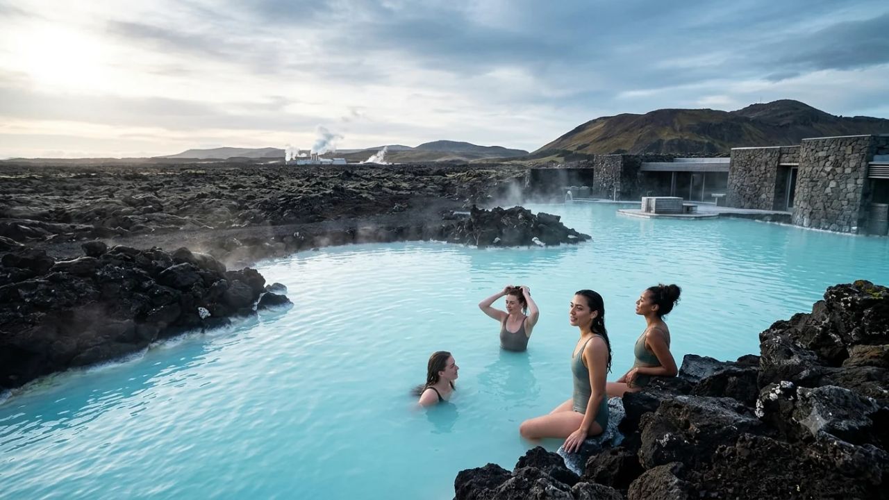
Iceland's Blue Lagoon geothermal spa continues welcoming international visitors under continuous real-time geophysical monitoring by the Icelandic Meteorological Office.
REYKJAVÍK, Oct 31 (Nomad Lawyer) — International travelers continue to arrive in steady numbers at Iceland's celebrated Blue Lagoon geothermal spa on the Reykjanes Peninsula, even as the Icelandic Meteorological Office (Veðurstofa Íslands) confirms ongoing magma accumulation and steady ground deformation beneath the neighboring Svartsengi volcanic complex. Following an authoritative scientific briefing published on October 27, 2026, geophysicists have determined that subsurface magma inflow continues unabated, establishing a renewed magma intrusion along the Sundhnúkur crater row as the most probable forthcoming geological scenario.
[!NOTE] Operational Status Summary: As of late October 2026, the Blue Lagoon, the Retreat Hotel, the Silica Hotel, and associated restaurants remain fully open and accessible via designated arterial bypasses. Keflavík International Airport (KEF) operates on normal schedules with zero flight disruptions. However, travelers must maintain active travel contingency plans, monitor civil protection alerts from Almannavarnir, and adhere strictly to localized safety parameters.
REYKJANES PENINSULA GEOPHYSICAL MONITORING & CONTINGENCY SYSTEM
| Column 1 |
|---|
| [Subsurface Magma Reservoir] ----> Depth: 4-5 km beneath Svartsengi Complex |
| v |
| [Geodetic Deformation Arrays] ---> Continuous GPS Stations & Satellite InSAR Uplift |
| v |
| [Seismic Sensor Network] --------> Real-Time Micro-Earthquake Swarm Detection |
| v |
| [Icelandic Met Office (IMO)] ----> Hazard Assessment & Probabilistic Modeling |
| v |
| [Civil Protection (Almannavarnir)] -> Multi-Tier Alert Dispatch (Uncertainty/Alert) |
| +---------+-----------------------+-------------------------+ |
| v v v |
| [Defensive Berms] [Blue Lagoon Evacuation] [Aviation Corridors] |
| Engineered gravel barriers Automated siren protocols Keflavík Airport (KEF) |
| protecting power plants Clears site in 30-40 min Standard non-explosive basalt |
| and visitor installations via unobstructed routes fissures maintain operations |
Geological Dynamics at Svartsengi: Deciphering the October 2026 IMO Assessment
The southwestern tip of Iceland represents one of the planet's most rigorously instrumented geodynamic laboratories, situated squarely over the divergent continental boundary separating the North American and Eurasian tectonic plates. Beneath the surface of the Reykjanes Peninsula, tectonic spreading opens fissures in the Earth's crust at an average rate of approximately two centimeters each year. Over the past five years, this regional extensional regime has transitioned from an eight-hundred-year period of relative quiescence into a high-energy eruptive cycle characterized by episodic magma accumulation, crustal fracturing, and fissure eruptions.
According to the comprehensive geological status assessment released by the Icelandic Meteorological Office on October 27, 2026, geodetic data recorded by continuous Global Navigation Satellite System (GNSS) stations and satellite-borne Interferometric Synthetic Aperture Radar (InSAR) confirm that magma inflow into the Svartsengi crustal reservoir continues at a stable, measurable pace. The geodetic instruments positioned across the Svartsengi geothermal field and surrounding lava plains indicate persistent vertical ground uplift, reflecting the pressurized accumulation of molten basalt at depths between four and five kilometers beneath the surface.
While seismic activity along the Sundhnúkur crater row—the primary eruptive rift segment running northeast of the evacuated town of Grindavík—has registered at baseline or relatively low levels throughout mid-to-late October 2026, geophysicists emphasize that low seismicity does not signal geological dormancy. In volcanic systems driven by repeated rifting events, magma chambers frequently inflate under steady hydrostatic pressure with minimal micro-seismic fracturing until crustal stress thresholds are exceeded. Once the tensile strength of the overlying basalt host rock is overcome, magma can abruptly breach the reservoir roof, triggering a rapid lateral dike propagation or a direct vertical ascent toward the surface within a window of only a few hours.
The Icelandic Meteorological Office specifically concluded that a renewed magma intrusion beneath the Svartsengi and Sundhnúkur region remains the most probable future scenario, with the potential to feed a new volcanic fissure eruption. Scientists caution that because each successive rifting event alters the local stress field and crustal pathway geometry, the exact timing, surface location, and volumetric effusion rate of future eruptions cannot be forecast with absolute calendar precision. For international visitors and local tourism stakeholders alike, this scientific reality underscores the necessity of relying exclusively on empirical monitoring updates rather than visual assumptions based on calm surface conditions.
Structural Engineering and Protective Dykes: Safeguarding Critical Infrastructure
The continued operation of world-class tourism facilities alongside active volcanic rift zones is made possible by unprecedented civil engineering interventions designed to insulate essential services from advancing lava flows. Following the dramatic reactivation of the Reykjanes volcanic system, Icelandic authorities, in partnership with structural engineering firms and geological consultants, initiated the largest protective earthwork undertaking in modern national history.
Surrounding both the Svartsengi Geothermal Power Plant—which supplies hot water, electricity, and heating to tens of thousands of homes across the Suðurnes region—and the adjoining Blue Lagoon leisure complex, engineers have erected an extensive network of massive earthen defensive dykes and gravel barriers. These protective berms, in some segments standing more than eight to ten meters high and measuring dozens of meters wide at their base, are engineered to channel, deflect, and arrest advancing basaltic lava flows away from critical infrastructure, control facilities, and guest access roads.
| Protective Asset / Infrastructure | Structural Dimensions & Materials | Primary Functional Objective | Current Operational Status |
|---|---|---|---|
| Svartsengi Defensive Berms | Compacted basalt gravel, height 8–12 meters | Deflects lava flows away from regional geothermal wells, power turbines, and district heating plants | Fully reinforced and maintained under continuous structural inspection |
| Blue Lagoon Perimeter Dykes | Layered riprap and reinforced volcanic rock | Shields bathing basins, guest amenities, Silica Hotel, and Retreat Hotel from lateral flows | Intact, with dedicated heavy equipment stationed for emergency earthworks |
| Grindavík Northern Barrier | High-capacity engineered gravel embankment | Redirects volcanic effusions originating along the Sundhnúkur crater row eastward | Active protection line, successfully tested during multiple 2024–2026 fissure events |
| Route 43 Access Corridor | Raised roadway base with culverts and protective shoulders | Maintains arterial transport connectivity between Highway 41 and the Svartsengi enclave | Operating under designated bypass alignments with emergency maintenance access |
The engineering methodology behind these barriers incorporates empirical observations gathered during multiple eruptive episodes between late 2023 and 2026. As molten basalt encounters the outer face of an engineered barrier, the fluid lava cools and solidifies upon contact with the dense, compacted rock aggregate, forming an insulating crust that causes subsequent flow lobes to divert along the barrier's outer flank rather than overtopping the crest. Civil protection authorities maintain earthmoving excavators and heavy industrial machinery on site at Svartsengi around the clock, providing the technical capacity to reinforce low spots or elevate specific berm sections within hours of an emerging eruption.
These structural fortifications have fundamentally altered the risk environment for the Blue Lagoon. Rather than existing as an unprotected installation in an open volcanic plain, the complex sits within an engineered sanctuary specifically built to withstand effusive Hawaiian- and Icelandic-type fissure eruptions. While these measures cannot eliminate the operational disruptions caused by toxic gas emissions or transport corridor cutoffs, they provide robust physical security against catastrophic structural loss.
The Blue Lagoon Operational Model: Balancing Wellness Tourism and Geophysical Reality
At the center of southwestern Iceland's tourism economy lies the Blue Lagoon, an internationally acclaimed wellness resort that draws hundreds of thousands of international visitors annually. Formed originally as an accidental byproduct of operations at the adjacent Svartsengi Geothermal Power Plant in the late 1970s, the lagoon holds approximately nine million liters of mineral-rich geothermal seawater maintained at a soothing year-round temperature between 37°C and 39°C (98°F to 102°F). The unique visual aesthetic of the pool—a milky, luminous blue contrasted sharply against surrounding expanses of jagged, moss-draped black basalt—derives from high concentrations of silica, mineral salts, and specialized blue-green algae.
The spa's ongoing operations demonstrate a sophisticated equilibrium between guest hospitality and rigorous safety management. The Blue Lagoon management team coordinates daily with the Department of Civil Protection and Emergency Management (Almannavarnir), the local police commissioner, and the Icelandic Meteorological Office to review subsurface pressure trends, gas dispersion forecasts, and localized environmental data before opening the facility to guests each morning.
The site encompasses not only the primary bathing lagoon but also high-end hospitality infrastructure, including the five-star Retreat Hotel, the boutique Silica Hotel, exclusive subterranean treatment sanctuaries, and fine-dining establishments such as Moss Restaurant and Lava Restaurant. Because the resort represents a premier bucket-list destination for transatlantic travelers, maintaining operational continuity without compromising guest welfare is paramount.
When visiting the facility during an active geological monitoring cycle, guests encounter an environment where safety protocols are embedded seamlessly into the service architecture. High-precision atmospheric sensors positioned around the perimeter of the bathing pools continuously monitor ambient concentrations of volcanic gases, primarily sulfur dioxide (SO2), hydrogen sulfide (H2S), and carbon dioxide (CO2). If shifting winds or localized volcanic venting push gas concentrations above conservative occupational thresholds, staff members initiate operational adjustments, which can range from relocating bathers to sheltered indoor facilities to pausing admissions entirely.
To prevent overcrowding during potential emergency evacuations, the Blue Lagoon strictly mandates advance timed bookings. This ticketing system allows operations managers to regulate the exact volume of visitors on the premises at any given hour, ensuring that total guest and staff headcounts never exceed the capacity of available transport and evacuation corridors. The resort maintains dedicated emergency shuttle buses on standby, and facility managers conduct regular procedural drills to ensure that staff can guide visitors from bathing pools to departure vehicles calmly and systematically.
Reykjanes Peninsula Volcanic History: Contextualizing the 2021–2026 Eruptive Epoch
To appreciate why magma accumulation beneath Svartsengi commands such widespread scientific attention, travelers must understand the geological timeline of the Reykjanes Peninsula. Unlike stratovolcanoes such as Mount Vesuvius or Mount St. Helens, which remain dormant for centuries before exploding in violent pyroclastic cataclysms, the volcanic systems of the Reykjanes Peninsula operate on cyclical rhythms alternating between multi-century sleep periods and sustained eruptive epochs lasting several hundred years.
Historical and tephrochronological records reveal that the peninsula experiences volcanic episodes roughly every 800 to 1,000 years, during which individual fissure swarms rupture intermittently over decades or centuries. The preceding active volcanic cycle concluded around the year 1240 CE with the Reykjanes Fires, after which the peninsula entered a protracted eight-century period of quiescent slumber.
| Historical Volcanic Event / Episode | Active Timeframe | Fissure / Eruptive Characteristics | Long-Term Impact on Peninsula Landscape |
|---|---|---|---|
| The Reykjanes Fires | 1210–1240 CE | Multiple fissure eruptions producing extensive pahoehoe and aa lava fields across southwest Iceland | Formed the regional basalt baseline and established the prolonged 800-year dormant epoch |
| Fagradalsfjall Eruptions | 2021–2022 | Low-intensity, tourist-accessible effusive fissure vents in Geldingadalir and Meradalir | Marked the official geological awakening of the Reykjanes Peninsula volcanic rift systems |
| Litli-Hrútur Episode | July–August 2023 | Fast-moving basaltic fissure eruption northeast of Fagradalsfjall with high gas emissions | Demonstrated accelerating magma migration rates through crustal fault networks |
| Sundhnúkur-Svartsengi Rift Series | Dec 2023 – Mid 2026 | Episodic high-effusion fissure ruptures along a four-kilometer rift line north of Grindavík | Led to the permanent evacuation of Grindavík and construction of major civil protection dykes |
| October 2026 Svartsengi Inflation | Current (Late 2026) | Steady geodetic ground uplift and magma accumulation at 4–5 km depth under low seismicity | Prompts active travel warnings and operational readiness for anticipated new magma intrusion |
The current eruptive chapter commenced in March 2021 with the eruption of Fagradalsfjall in Geldingadalir, which produced gentle lava fountains and meandering lava rivers that attracted tens of thousands of global hikers. However, as the regional tectonic stresses shifted westward into the Eldvörp-Svartsengi volcanic system in late 2023, the character of volcanic activity evolved from isolated backcountry events into structural threats against settled communities and vital infrastructure.
Between December 2023 and the summer of 2026, the Sundhnúkur crater row witnessed multiple distinct eruptive breakouts. Each episode followed a recognizable pattern: weeks or months of progressive ground inflation beneath Svartsengi accompanied by steady magma pooling, followed by intense seismic swarms lasting between thirty minutes and several hours, culminating in the opening of long eruptive fissures spewing basaltic lava curtains into the sky.
The October 2026 scientific assessment from the Icelandic Meteorological Office confirms that this underlying rhythmic engine remains active. The volume of magma recharged into the crustal reservoir has reached levels comparable to those observed prior to previous ruptures. Recognizing this cyclic pattern enables travelers to view current advisories not as alarms of impending disaster, but as the expected behavior of a dynamic mid-ocean rift zone navigating an active geological era.
Aviation Corridors, Keflavík International Airport, and Regional Road Networks
A recurring concern among international travelers planning an Icelandic journey is whether volcanic unrest on the Reykjanes Peninsula threatens commercial aviation schedules. Memories of the 2010 Eyjafjallajökull eruption, which grounded European airspace for nearly a week and stranded millions of airline passengers, frequently spark unwarranted anxiety when volcanic headlines emerge from Iceland.
Geologists and aviation authorities emphasize that the geological mechanisms driving eruptions on the Reykjanes Peninsula are fundamentally distinct from the subglacial dynamics of Eyjafjallajökull. Eyjafjallajökull's massive ash cloud was generated because explosive basaltic and dacitic magma interacted directly with hundreds of meters of glacial ice cap, flash-boiling water into steam and shattering molten rock into microscopic, abrasive silica ash particles capable of traveling thousands of kilometers in the upper troposphere.
In contrast, the volcanic systems of the Reykjanes Peninsula—including the Sundhnúkur and Svartsengi rifts—are subaerial effusive basalt systems situated entirely on ice-free terrain. The molten basalt produced during these fissure eruptions is low in dissolved volatile gases and fluid in composition, resulting in localized fire-fountaining and expanding lava sheets rather than high-altitude explosive ash columns.
Keflavík International Airport (KEF), situated approximately twenty kilometers northwest of the Svartsengi complex, remains fully operational throughout these volcanic cycles. Flight operations under the direction of Isavia, Iceland's airport and air navigation authority, proceed without systemic interruption. International carriers, including Icelandair, Play, Delta Air Lines, United Airlines, and British Airways, operate standard transatlantic and European connections. Even when fissure eruptions occur along the Sundhnúkur row, prevailing regional wind patterns typically disperse localized steam and volcanic gas away from airport approach paths.
On the ground, transportation networks across the peninsula are managed with targeted flexibility. The primary transport artery connecting Keflavík International Airport to the capital city of Reykjavík—Highway 41 (Reykjanesbraut)—remains completely unaffected by volcanic activity, as it traverses terrain well outside the projected runout zones of Svartsengi lava flows.
Local road networks directly serving Grindavík and the Blue Lagoon require careful daily monitoring. Route 43 (Grindavíkurvegur), which serves as the traditional access corridor to the lagoon, has experienced intermittent closures and localized diversions during past eruptive events where advancing lava crossed road surfaces. In response, road authorities from Vegagerðin have constructed elevated bypass routes and reinforced secondary conduits, such as Route 425 (Nesvegur) and Route 427 (Suðurstrandarvegur), ensuring that multiple ingress and egress pathways remain functional.
Traveler Contingency Protocols: Real-Time Alerts, Evacuation Readiness, and Gas Safety
Traveling through a volcanically active region demands proactive situational awareness, disciplined preparation, and immediate compliance with official instructions. While Iceland maintains some of the most proficient search-and-rescue organizations in the world—led by the volunteer squads of Landsbjörg (ICE-SAR)—travelers must take responsibility for their own safety by establishing comprehensive trip contingencies.
Civil protection authorities classify regional risks into defined operational tiers. Understanding these tiers allows visitors to interpret news releases accurately and take proportionate actions without succumbing to unwarranted panic.
| Civil Protection Alert Level | Regulatory Definition & Field Conditions | Practical Traveler Implications | Recommended Visitor Action |
|---|---|---|---|
| Uncertainty Phase (Óvissustig) | Magma accumulation detected; steady ground uplift with baseline seismicity | Tourist sites open; transport networks normal; scientific surveillance intensified | Monitor official updates daily on SafeTravel.is and Vedur.is; keep itineraries flexible |
| Alert Phase (Hættustig) | Elevated seismic swarms; accelerated strainmeter rates indicating imminent dike intrusion | Preemptive precautionary measures; access roads to high-risk zones restricted | Reconfirm Blue Lagoon booking status; expect potential facility pauses or early departures |
| Emergency Phase (Neyðarstig) | Active fissure eruption underway; localized lava outflow and dynamic gas plumes | Immediate closure of the eruption vicinity; public excluded from hazard zones | Follow all evacuation siren directives; depart via designated bypass corridors immediately |
| Post-Eruption Stabilization | Active lava output ceases; surface cooling begins; ongoing ground deformation assessment | Infrastructure inspections underway; road repairs and air quality clearance ongoing | Await formal reopening announcements; do not enter fresh, fragile lava crusts |
The most critical localized hazard during any eruptive cycle on the Reykjanes Peninsula is not molten rock itself, which typically advances at a pace that allows ample time for motorized retreat, but invisible volcanic gas emissions. When basaltic magma depressurizes near the surface, it vents substantial volumes of sulfur dioxide (SO2), carbon dioxide (CO2), carbon monoxide (CO), and hydrogen sulfide (H2S).
Sulfur dioxide is a pungent, irritating gas that can cause severe respiratory distress, eye inflammation, and throat irritation, particularly among travelers with preexisting medical conditions such as asthma, bronchitis, or cardiovascular disease. Carbon dioxide and carbon monoxide are odorless, heavier-than-air gases that tend to pool in topographic depressions, ravines, and low-lying hollows within lava fields, presenting fatal asphyxiation risks to unwary hikers who stray off designated wooden boardwalks.
The Blue Lagoon operates an extensive network of automated public address speakers and sirens linked directly to the national civil protection emergency network. In the event that rapid evacuation becomes necessary due to escalating seismicity or localized fissure breakouts, visitors are alerted by distinct auditory alarms and guided by trained security personnel. Evacuation protocols are engineered to clear the entire facility—including bathers in the water, hotel guests, and restaurant patrons—within thirty to forty minutes. Guests are escorted directly to their rental vehicles or waiting emergency shuttles, which depart along pre-cleared northern escape routes connecting smoothly to Highway 41.
Travelers are strongly urged to register their travel itineraries with SafeTravel.is, the official national travel safety portal. By registering contact numbers and enabling location services, visitors ensure that national emergency text alerts (SMS) dispatched by 112 emergency services will reach their mobile devices instantly if localized warnings are triggered.
Economic and Regulatory Frameworks: The Resilience of Iceland's Geothermal Economy
The coexistence of volatile volcanic rift systems and thriving high-value tourism illustrates the resilience of Iceland's unique economic model. Tourism has served as one of the primary pillars of the national economy since the financial reorganization of the early 2010s, contributing significantly to foreign exchange reserves, regional employment, and national gross domestic product.
Within this framework, the Svartsengi enclave represents a critical nexus where renewable energy generation and luxury wellness travel converge. The Svartsengi Geothermal Power Plant, operated by HS Orka, was the first geothermal plant in the world to combine electric power production with regional district space heating, extracting high-temperature geothermal brine from deep boreholes drilled directly into the volcanic fractures.
The economic symbiotic relationship between HS Orka and the Blue Lagoon is a model of industrial ecology: the warm, mineral-saturated silica water that fills the resort's bathing basins is the exact discharge fluid emerging from the plant's heat exchangers. Consequently, civil protection investments designed to safeguard Svartsengi do not merely protect a popular swimming destination; they defend the vital energy lifeline sustaining the domestic heating, water sanitation, and industrial operations of the entire Reykjanes community.
The Icelandic Parliament (Alþingi) recognized this strategic reality by passing specialized legislation that authorized funding for the construction of the defensive barriers surrounding Svartsengi and Grindavík through a temporary national property tax levy. This proactive public policy intervention reflects a national consensus that active volcanic hazards must be managed through engineering resilience rather than permanent regional abandonment.
For the international traveler, this institutional support ensures that facilities like the Blue Lagoon are backed by the full logistical, financial, and technical weight of the Icelandic government. The regulatory environment guarantees that when tourism facilities remain open, they do so under the strictest safety criteria established by independent geophysicists, civil engineers, and public health officials.
Essential Visitor Checklist: Managing Reykjanes Itineraries with Confidence
Visiting Iceland during an active volcanic cycle can be an extraordinary and enlightening experience, offering travelers an intimate perspective on the planetary forces that forge new land. However, turning this opportunity into a safe, seamless journey requires careful logistical planning and prudent operational management.
Travelers intending to include the Blue Lagoon or the broader Reykjanes Peninsula in their upcoming Icelandic itinerary should adhere to the following practical guidelines:
First, maintain flexible reservations across all travel bookings. When booking admissions to the Blue Lagoon, opt for refundable ticket tiers or book through travel insurance policies that provide explicit cancellation and interruption coverage for natural events and volcanic disruptions. The Blue Lagoon management operates a customer-friendly rescheduling policy during official civil protection closures, permitting guests to alter booking dates or receive full refunds when access is restricted.
Second, monitor official Icelandic information platforms at least twice daily. Prior to setting out on your journey from Reykjavík or Keflavík, check the live status updates on three essential websites: SafeTravel.is for regional safety alerts and weather warnings, Vedur.is (Icelandic Meteorological Office) for real-time volcanic status reports and earthquake maps, and Road.is (Vegagerðin) for live road condition cameras and closure maps. Avoid relying on unverified social media commentary, international tabloid headlines, or rumors circulating in tourist forums.
Third, pack appropriate personal protective items and all-weather apparel. Even during spa visits, regional travel across the volcanic fields requires sturdy, ankle-supporting waterproof hiking boots, thermal base layers, and windproof outer shells. Individuals with asthma or underlying respiratory conditions must carry their prescribed inhalers and medications at all times, as sudden shifts in wind direction can transport faint sulfur plumes across wide geographical areas.
Fourth, honor all physical barriers, road closure signs, and warning notices without exception. Walking onto newly cooled lava fields is exceptionally hazardous; thin surface crusts can conceal hollow lava tubes or glowing molten rock reaching temperatures exceeding 1,000°C just inches beneath the surface, while jagged basalt shards can shred footwear. Do not attempt to hike into restricted zones or treat closed bypass roads as photo opportunities.
Fifth, ensure that your rental vehicle is equipped with a functioning mobile phone charger, offline GPS navigation maps downloaded to your device, and a full tank of fuel. Having adequate fuel ensures that if localized road diversions require taking secondary regional bypasses, your vehicle can comfortably complete the journey without refueling delays.
By adopting this structured, informed approach to travel on the Reykjanes Peninsula, visitors can experience the soothing warmth and restorative waters of the Blue Lagoon with total peace of mind, fully appreciating Iceland as a vibrant, living land where nature's power and human ingenuity exist in harmony.
Related Travel Guides
- Nepal Suspends Restricted-Area Trekking Permits Amid Himalayan Snowstorms
- Middle East Flight Disruptions and Airspace Closures: Traveler Contingency Guide
- US-Bound Flights Mandatory Health Declarations and Boarding Protocols
- Air France Extends Middle East Flight Suspensions Across Key Hubs
- Hanoi Tourism Strategy 2030: Master Plan and International Arrival Projections
This article is for informational purposes. Flight routes, passenger regulations, visa rules, and transit advisories are subject to change by airlines and aviation authorities. Readers are advised to verify schedules and travel documentation with relevant carriers and border agencies before departure.
Related Stories

Barcelona and Paris Heighten Halloween 2026 Security Amid Youth Protests and Riots as Authorities Clarify Tourist Hotspots Remain Open
Global Volcano Travel Alerts 2026: Indonesia, New Zealand, Japan, Iceland and Italy Access Rules