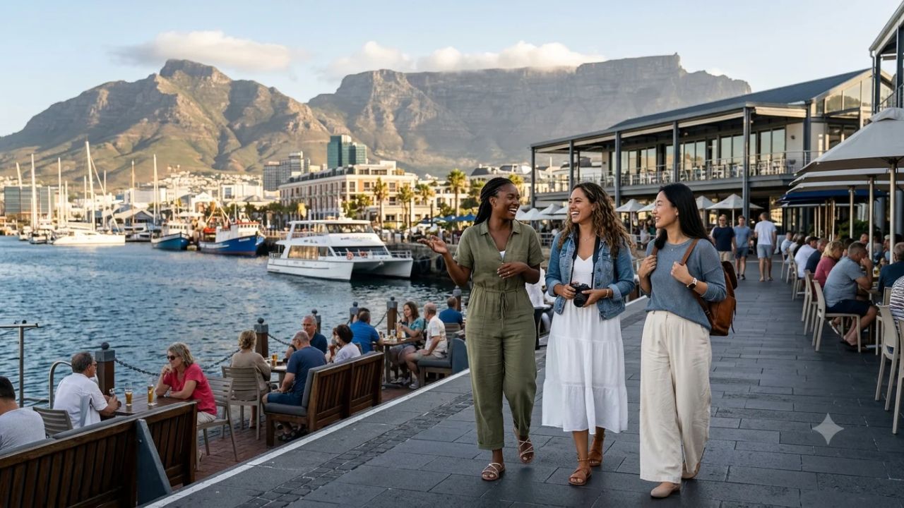
Cape Town Completes Table View Beachfront Coastal Transformation Ahead of 2026-2027 Summer Season

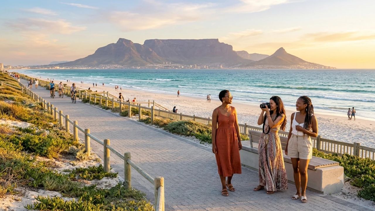
CAPE TOWN, November 4, 2026 — The City of Cape Town has entered the final operational stage of its landmark Table View beachfront revitalization, concluding a comprehensive four-year civil engineering, ecological restoration, and urban redesign initiative along the Blaauwberg coastal corridor. Stretching three continuous kilometers from Marine Circle northward past Dolphin Beach to Bokkombaai, the project represents one of the Western Cape’s most ambitious municipal coastal interventions. Scheduled for final handover by mid-December 2026, the upgraded shoreline delivers modern civic infrastructure strategically timed for the southern hemisphere's peak summer holiday influx, transforming a historically eroded coastline into a resilient model for sustainable urban tourism and climate adaptation.
Initiated in July 2022 to counter escalating coastal erosion, wind-blown sand drifts, and deteriorating public amenities, the transformation pairs heavy subterranean drainage improvements with sensitive dune ecology revegetation. Beyond aesthetic and recreational enhancements, the project provides a protective buffer against rising sea levels and intense Atlantic winter storm surges while establishing dedicated economic infrastructure for local commercial venues, digital nomads, and international eco-travelers. With private hospitality operators investing over fifty million rand in surrounding boutique accommodations and foot traffic projected to climb up to thirty percent over the coming year, Table View has evolved from a windswept commuter beach into a world-class seaside destination showcasing panoramic vistas of Table Mountain across Table Bay.
TABLE VIEW REVITALIZATION METRIC SCORECARD
| Project Dimension | Historical Baseline | Post-Upgrade Metric | Strategic Target |
|---|---|---|---|
| Continuous Coastal Walkway | Disconnected Pathways | 3.0 Kilometers Paved | Marine Circle-Bokkom. |
| Dune Ecology Revegetation | Severe Wind Erosion | 12,000 m² Restored | 40% Sand Stabilization |
| Subterranean Drainage Pipe | Vulnerable Outfalls | 2.0 km Reinforced | 50-Year Flood Standard |
| Foot Traffic Projection | Stagnant Off-Season | +25% to +30% Surge | Annualized Growth |
| Private Hospitality Capital | Limited Local CapEx | R50+ Million Invested | Boutique Upgrades |
| Peak Dining Patronage | Seasonal Dip | +28% Evening Volume | Sustainable Seafood |
| Remote Work Stay Duration | Standard 7-Day Leisure | 21-Day Average Stay | Digital Nomad Corridor |
The Civil Engineering Framework: From Dune Stabilization to a Three-Kilometer Promenade
The physical restructuring of Table View’s shoreline resolved decades of haphazard urban sprawl and environmental degradation along Otto du Plessis Drive. When municipal teams broke ground in July 2022, the immediate operational focus was stabilizing the shifting littoral dunes, which routinely deposited tons of loose sand across public roadways, parking courts, and private residences during the notorious south-easterly summer winds (the Cape Doctor). Over the subsequent forty-eight months, civil contractors re-engineered the coastal interface, creating a continuous, three-kilometer paved pedestrian and cycling corridor that connects Marine Circle directly to the sheltered cove of Bokkombaai.
This wide promenade serves as a dedicated non-motorized transport corridor, removing pedestrian congestion from adjacent vehicular roadways while providing unimpeded ocean panoramas. To accommodate visitors arriving by private transport without compromising beachfront sightlines, municipal engineers reconfigured vehicular access points. Brand-new parking installations were established opposite Visagie Street, complemented by expanded, resurfaced parking bays at Bokkombaai. These parking areas incorporate low-profile boundary berms and porous paving stones that facilitate natural rainwater absorption into subterranean water tables rather than directing polluted runoff into the ocean.
In its concluding phase, construction teams are finalizing the complete refurbishment of public ablution blocks, outdoor rinse showers, and municipal utility connections. The modernized facilities integrate water-saving sensor fixtures, vandalism-resistant sanitaryware, and energy-efficient solar water heaters. By scheduling the final structural handovers for mid-December 2026, city planners ensured that domestic holidaymakers and international tourists arriving for the festive season will experience an unencumbered, pristine public realm.
                    TABLE VIEW INTEGRATED COASTAL INFRASTRUCTURE

       [ Subterranean Resilience ]                   [ Surface Recreation & Nature ]
       Hydraulic & Coastal Defenses                  Eco-Promenade & Dune Sanctuaries
  +------------------------------------+       +-------------------------------------------+
  | - 2 km Reinforced Concrete Drainage|       | - 3 km Continuous Paved Coastal Promenade |
  | - 50-Year Threshold Storm Outfalls | ====> | - 12,000 m² Indigenous Dune Revegetation  |
  | - Porous Permeable Parking Bays    |       | - Universal Disabled Boardwalk Access     |
  | - Naturalized Stone Rip-Rap Seawall|       | - High-Speed Municipal Wi-Fi & Smart Bins |
  +------------------------------------+       +-------------------------------------------+
Ecological Dune Rehabilitation: Restoring 12,000 Square Meters of Coastal Fynbos
The centerpiece of the municipal strategy is an expansive ecological dune rehabilitation program that prioritizes nature-based engineering over rigid concrete sea walls. Over the course of the project, environmental specialists re-profiled damaged sand dunes across more than twelve thousand square meters of shoreline, reconstructing natural coastal gradients capable of absorbing powerful Atlantic wave energy.
To anchor the shifting sand banks, horticulturists executed an intensive revegetation program utilizing drought-tolerant indigenous coastal plants. Species such as sour fig (Carpobrotus edulis), sea wheat (Thinopyrum distichum), and dune cineraria (Senecio elegans) were propagated in specialized municipal nurseries and hand-planted across the re-sculpted contours. These deep-rooting succulents and coastal grasses bind loose sand particles, establishing resilient subterranean root networks that have reduced wind-driven sand displacement by forty percent across monitored sectors.
To safeguard this fragile botanical zone against human degradation, the municipality installed thousands of meters of treated timber post-and-rail fencing, guiding beachgoers along formal boardwalks and elevated wooden ramps. The exclusion of random foot traffic has catalyzed a measurable biological revival. Avian monitoring by local conservation trusts documents the sustained return of indigenous coastal bird species, including the African black oystercatcher (Haematopus moquini) and kelp gulls, alongside small intertidal crustaceans and marine mollusks that thrive in undisturbed littoral sands.
COASTAL ECOLOGICAL REHABILITATION MATRIX
| Entity / Facility | Delays | Cancellations | Details |
|---|---|---|---|
| Ecological Zone | Surface Footprint | Primary Botanical Species | Environmental Function |
| Fore-Dune Embryo Banks | 4,500 m² Frontage | Thinopyrum distichum | Initial Wave Buffering |
| Primary Vegetated Ridge | 5,200 m² Crest Area | Carpobrotus edulis | Sand Matrix Anchoring |
| Hind-Dune Stabilization | 2,300 m² Rear Fringe | Senecio elegans, Fynbos | Wind-Drift Mitigation |
| Intertidal Littoral Strip | Variable Marine Edge | Indigenous Algae & Kelp | Marine Fauna Sanctuaries |
Subterranean Resilience: 50-Year Stormwater Mitigation and Climate Adaptation
While the beachfront promenade provides visible public enjoyment, the civil works below ground represent a decisive defense against changing climate patterns. Table Bay’s coastal plain has historically remained vulnerable to severe winter cold fronts originating in the Southern Ocean, which unleash torrential rains and destructive wave action between May and August. Dated stormwater pipes frequently backed up during high tides, flooding commercial basements along Otto du Plessis Drive and eroding public access staircases.
To eliminate these vulnerabilities, civil engineers replaced obsolete drainage infrastructure with more than two kilometers of reinforced, corrosion-resistant concrete piping designed to withstand a fifty-year storm event threshold without structural failure or hydraulic backflow. The subterranean network routes surface runoff through specialized sand-and-grease interceptors, cleansing stormwater of road debris and petroleum residues before releasing it into deep-water marine outfalls.
At vulnerable shoreline convergence points, engineers reinforced existing seawalls with naturalized stone rip-rap revetments. The heavy granite boulders dissipate incoming wave velocity through internal friction rather than deflecting wave shock into adjacent sand banks, substantially extending the engineering lifespan of the installations to an estimated twenty-year lifecycle. This proactive hydraulic defense ensures that rising sea levels and intense winter storms will not compromise public safety or sever coastal transportation links.
       TABLE BAY SUBTERRANEAN STORMWATER & RIP-RAP DISPERSION

       +-------------------------------+
       | Urban Runoff & Road Drainage  |
       | (Otto du Plessis / Commercial)|
       +---------------+---------------+
                       |
       +---------------+---------------+
       | Sand & Hydrocarbon Interceptors|
       | (Subterranean Cleansing Unit) |
       +---------------+---------------+
                       |
       +---------------+---------------+
       |                               |
       v                               v
+-----------------------------+ +-----------------------------+
| 2 km Reinforced Concrete Pipe| | Granular Infiltration Beds  |
| - 50-Year Flow Capacity     | | - Porous Pavement Parking   |
| - Marine Deep-Water Outfall | | - Natural Aquifer Recharge  |
+-----------------------------+ +-----------------------------+
Economic Multipliers: Retail Foot Traffic, Hospitality Investments, and Private Capital
The revitalization of Table View has triggered a powerful economic response across surrounding commercial sectors. Urban economists evaluate municipal infrastructure investments by their capacity to catalyze private sector capital, and Table View’s outcome underscores this multiplier dynamic. Financial projections indicate that the modernized beachfront will generate a twenty-five to thirty percent expansion in overall foot traffic during the 2026–2027 fiscal year.
This foot traffic growth translates into direct revenue expansion for independent restaurateurs, cafes, surf outfitters, and retailers. Small commercial venues anticipate a fifteen percent boost in daily patronage during peak summer weeks, with evening trade demonstrating the sharpest growth due to the well-illuminated, safe pedestrian promenade. Small business operators report heightened commercial confidence, leading to staff expansions and extended operating hours.
Private hospitality investors have responded enthusiastically to the public sector's leadership. Regional property registries document that private guesthouse owners and boutique hotel operators injected over fifty million rand (ZAR) into property refurbishments, interior redesigns, and sustainability retrofits across the Marine Circle and Dolphin Beach districts throughout 2026. Independent lodging providers report an average thirty-five percent increase in advance holiday reservations for the upcoming summer peak compared to the previous year. To satisfy international guest expectations, over ninety percent of regional accommodation providers have integrated cloud-based booking engines and contactless check-in platforms, modernizing the area’s hospitality operational profile.
The economic revitalisation is intimately tied to Table View’s reputation as an international watersports capital. Known globally as one of the premier kitesurfing, wingfoiling, and windsurfing destinations on Earth, the coastline benefits from the powerful summer south-easterly wind, affectionately termed the Cape Doctor. Blowing side-shore between twenty-five and thirty-five knots against rolling Atlantic swells, these conditions draw thousands of professional extreme sports athletes and seasonal wind-chasers from across Europe, North America, and Australia. The area regularly serves as the training amphitheater and spectator arena for elite international competitions, including the world-renowned Red Bull King of the Air tournament.
Prior to the municipal overhaul, extreme athletes, casual strollers, and vehicular traffic competed for narrow, deteriorating pathways, often resulting in trampled dunes and damaged gear. The new infrastructure addresses these operational bottlenecks by integrating dedicated turf rigging lawns, outdoor freshwater equipment washdown bays, and secure storage lockers directly adjacent to certified kitesurfing schools. By formalizing spaces for extreme watersports, the city has preserved Table View's adventurous identity while creating a seamless, organized environment for leisure travelers who gather along the promenade to watch kiteboarders leap thirty meters into the sky against the backdrop of Table Mountain.
ECONOMIC IMPACT & HOSPITALITY INVESTMENT TRAJECTORY
| Entity / Facility | Delays | Cancellations | Details |
|---|---|---|---|
| Commercial Sector | Pre-Upgrade Condition | Measured 2026 Shift | Projected 2027 Outcome |
| Small Business Trade | Modest Day Footprint | +15% Peak Daily Sales | +25% Sustained Turnover |
| Coastal Restaurant Trade | Concentrated Lunch | +28% Evening Diners | Year-Round Viability |
| Hospitality Lodging | Standard Guesthouses | R50M+ Private Capital Influx | 4-Star Boutique Cluster |
| Advance Summer Bookings | Late Booking Window | +35% Forward Reservations | Full Summer Occupancy |
| Regional Employment | Seasonal Fluctuations | Steady Payroll Expansion | Permanent Service Jobs |
Ethical Gastronomy, Evening Leisure, and the Bokkombaai Culinary Corridor
A notable consequence of the beachfront upgrade is the emergence of Table View as an ethical culinary destination. Historically, casual beach dining along the stretch was dominated by fast-food outlets and high-turnover snack bars. The establishment of the scenic coastal walkway has reshaped dining behaviors, encouraging guests to combine late-afternoon strolls with relaxed multi-course evening meals.
Seafood establishments and artisanal bistros clustered near Bokkombaai and Dolphin Beach have recorded a twenty-eight percent surge in evening customer counts. In response to global traveler demand for environmental accountability, leading restaurateurs have eliminated red-listed marine species, partnering with the Southern African Sustainable Seafood Initiative (SASSI) to offer certified green-listed, line-caught fish such as yellowtail (Seriola lalandi) and Cape bream (Pachymetopon blochii).
This culinary evolution extends into scheduled cultural food festivals. Regional tourism boards have unveiled plans for coastal culinary exhibitions along the promenade, bringing artisanal olive oil producers, Swartland winemakers, and local craft brewers directly to seaside visitors. These seasonal events are forecasted to attract over twenty thousand domestic and international visitors, dispersing economic benefits into regional agricultural supply chains across the Western Cape.
The geographical identity of Bokkombaai itself is steeped in centuries of indigenous fishing culture. The cove takes its name from bokkoms, a traditional delicacy of the West Coast dating back to seventeenth-century artisanal fishing settlements. Prepared by salting juvenile southern mullet (harders) in sea brine and air-drying them across open wooden trellises in the salty sea winds, bokkoms provided essential sustenance for generations of coastal families. Modern bistros along the walkway celebrate this heritage through sophisticated interpretations, serving shaved cured mullet atop artisanal sourdough flatbreads and pairing coastal seafood stews with crisp Chenin Blanc from the nearby Swartland wine region.
Evening dining along the restored shoreline also incorporates authentic South African culinary rituals, notably communal potjiekos. As the sun dips behind the silhouette of Robben Island in the middle of Table Bay, visitors can observe local families and restaurant patios preparing these slow-cooked cast-iron stews over aromatic rooikrans wood coals. Layers of fresh linefish, black mussels, calamari, potatoes, and sweet Cape onions simmer gently for hours, infused with aromatic Cape Malay spices such as crushed coriander, star anise, turmeric, and dried apricots. These sensory culinary traditions transform an ordinary evening walk along the promenade into an immersive cultural exploration of the Western Cape's rich maritime heritage.
[!NOTE] Travelers visiting Table View during the summer festive season are advised to reserve evening dining tables along Marine Circle and Bokkombaai at least one to two weeks in advance, particularly for venues offering sunset views of Table Mountain.
Smart Tourism, Digital Nomad Influx, and 21-Day Long-Stay Economics
The Table View upgrade integrates modern digital infrastructure designed to attract contemporary lifestyle travelers. Recognizing that digital connectivity is an essential public utility for global tourists, the City of Cape Town deployed high-speed municipal Wi-Fi access points at strategic gathering plazas along the promenade, enabling visitors to access public transit information, weather updates, and navigational maps without consuming personal cellular data.
To manage environmental cleanliness efficiently, the municipality installed solar-powered smart waste receptacles equipped with volumetric compaction sensors. When waste levels reach capacity, the sensors transmit automated collection requests to municipal cleansing depots, optimizing truck routes, preventing trash overflow, and keeping windswept litter from entering marine habitats. Digital message boards provide real-time updates regarding ocean surf conditions, ultraviolet radiation indices, and shark spotter flags, enhancing bather safety.
       TABLE VIEW SMART DIGITAL AND NOMAD ARCHITECTURE

       +-------------------------------+
       | Municipal Fiber-Optic Backbone|
       | (High-Speed Waterfront Wi-Fi) |
       +---------------+---------------+
                       |
       +---------------+---------------+
       |                               |
       v                               v
+-----------------------------+ +-----------------------------+
| Smart City Civic Services   | | Digital Nomad Ecosystem     |
| - Solar Compaction Bins     | | - Ergonomic Seaside Desks   |
| - Real-Time Tidal Signage   | | - High-Yield 21-Day Stays   |
| - Automated Cleansing Alerts| | - Off-Peak Economic Support |
+-----------------------------+ +-----------------------------+
These technological advancements have catalyzed an influx of international remote workers. Table View has long attracted kitesurfers and water sports enthusiasts due to its consistent wind conditions; the integration of high-speed fiber connectivity has transformed seaside cafes and co-working spaces into thriving hubs for digital nomads. Remote professionals visiting Cape Town in 2026 registered a forty percent year-on-year increase in Table View accommodations.
Significantly for municipal planners, digital nomads average twenty-one days per visit—triple the duration of conventional leisure tourists. Because these long-stay professionals rent local apartments, dine daily at neighborhood eateries, and patronize neighborhood laundries and gyms throughout weekdays, their expenditure smooths out the sharp off-peak dips that historically plagued beachfront hospitality businesses.
To maintain continuous operational reliability for remote workers, commercial landlords and co-working operators along Marine Circle invested in private solar-inverter microgrids and lithium-battery energy storage systems. These installations guarantee uninterrupted gigabit fiber-optic connectivity, overcoming historical national power grid vulnerabilities. With ergonomic outdoor desks facing the ocean, soundproof podcasting suites, and meeting rooms available on flexible daily passes, Table View has established itself as South Africa's premier seaside remote-work enclave, aligning directly with national efforts to capture high-earning international telecommuters traveling under newly streamlined remote-work visa regulations.
Transit Integration and Universal Mobility: MyCiTi BRT and Inclusive Oceanfront Design
Sustainable urban tourism depends upon equitable, barrier-free access for all citizens and visitors, regardless of physical ability or economic background. The redesigned Table View beachfront incorporates universal design principles to ensure total physical inclusivity.
The continuous three-kilometer promenade has simultaneously sparked an active lifestyle revolution among residents and visitors. Public health advocates highlight how safe, well-surfaced non-motorized corridors encourage regular cardiovascular exercise. Every morning at dawn, local running clubs, cycling pelotons, and walking groups converge on the pathway, sharing space with dog walkers and parents pushing strollers. Municipal landscape designers complemented the pathway with outdoor calisthenics fitness parks, shaded wooden pergolas, and oceanfront stretching decks, creating a comprehensive wellness circuit along the coastline.
The infrastructure upgrade also directly supports maritime safety operations. The uninterrupted pathway provides vital logistical connectivity for volunteer lifeguard squads operating out of the Big Bay and Milnerton Surf Lifesaving Clubs. Lifeguards can now rapidly mobilize quad bikes, rescue watercraft, and medical first-responder equipment along the beachfront without getting bogged down in soft sand dunes, slashing emergency response times for swimmers and kiteboarders in distress across the surf zone.
Engineers replaced steep, irregular sand paths with graded access ramps conforming to international accessibility standards. Tactile ground surface indicators guide visually impaired beachgoers from public transit stops directly to the shoreline. The newly constructed public ablution buildings feature spacious, wheelchair-accessible stalls fitted with grab bars, low-level emergency assistance cords, and non-slip surfaces. In addition, wide wooden boardwalk sections allow individuals utilizing wheelchairs, mobility scooters, or family strollers to navigate seamlessly from parking lots down to ocean overlooks.
UNIVERSAL ACCESSIBILITY AND MOBILITY STANDARDS
| Entity / Facility | Delays | Cancellations | Details |
|---|---|---|---|
| Infrastructure Feature | Technical Standard | Functional Advantage | User Demographic |
| Promenade Access Ramps | 1:12 Gradient Slope | Seamless Barrier-Free Entry | Wheelchair / Strollers |
| Tactile Ground Paving | Directional Grooves | Non-Visual Route Guidance | Visually Impaired |
| Public Restroom Stalls | Universal Design Code | Emergency Cords, Wide Doors | Disabled Individuals |
| MyCiTi Transit Links | Level Platform Entry | Reduced Private Car Traffic | Commuters & Travelers |
| Shaded Pergolas | Anti-Glare Louvers | Rest & Sun-Protection Stops | Elderly & Families |
Public transportation integration complements these accessibility features through the expansion of Cape Town’s MyCiTi Bus Rapid Transit (BRT) network. Dedicated MyCiTi bus routes link central Cape Town, Century City, and the northern suburbs directly to newly sheltered passenger stations situated adjacent to Visagie Street and Marine Circle.
Transit surveys conducted during 2026 indicate that the enhanced bus corridors reduced private vehicle congestion along the coastal fringe by twenty-two percent, while visitor satisfaction ratings for the clean, monitored stations reached ninety-four percent. International travelers can land at Cape Town International Airport, board public transit connections, and arrive directly at their beachfront guesthouse without requiring private automobile rentals.
Public Safety, Cultural Heritage, and the Sustainable Horizon for Cape Town
To preserve a welcoming environment, municipal authorities paired physical infrastructure improvements with a multi-layered public safety framework. Law enforcement agencies installed high-definition closed-circuit television (CCTV) cameras along the entire three-kilometer corridor, monitored twenty-four hours a day from a central municipal command facility. On the ground, visible foot patrols conducted by municipal law enforcement personnel, private neighborhood security watches, and certified beach marshals provide effective deterrents against petty crime and opportunistic theft.
Emergency coordination is enhanced through numbered geographic waypoint markers placed every one hundred meters along the walkway. In the event of a medical emergency or water rescue incident, calling parties can quote the nearest marker number to dispatch emergency services with pinpoint accuracy. Community safety forums report a substantial decline in criminal incidents across the beachfront zone since the revitalisation works were introduced.
TABLE VIEW PUBLIC SAFETY ARCHITECTURE
| Entity / Facility | Delays | Cancellations | Details |
|---|---|---|---|
| Security Dimension | Operating Mechanism | Deployment Scale | Performance Benchmark |
| Video Surveillance | 24/7 Monitored CCTV | Continuous Promenade Span | Real-Time Intervention |
| Visible Foot Patrols | Law Enforcement Staff | Joint Civil & Marshal Teams | Zero-Tolerance Presence |
| Emergency Geo-Markers | Numbered Stanchions | Every 100 Meters | <6-Minute Response Time |
| Night Illumination | Solar-Powered LEDs | Full Walkway & Car Parks | Elevated Night Safety |
The transformation also honors the rich historical and environmental identity of Table Bay. In collaboration with local historians and cultural conservationists, the municipality integrated educational panels and curated public art installations along the promenade. Illustrated interpretive boards explain the maritime history of shipwrecks in Table Bay, the ancestral seasonal movements of indigenous Khoisan pastoralists, and the delicate life cycles of coastal fynbos flora.
Sculptures and murals crafted by regional artists celebrate Cape Town’s cultural diversity, transforming the walk into an open-air cultural gallery. Environmental compliance standards have simultaneously eliminated seventy-five percent of single-use plastics across beachfront hospitality properties, while municipal solar lighting and rainwater recycling installations have lowered regional municipal energy consumption by twenty percent annually.
As the final construction elements wrap up in mid-December 2026, the revitalized Table View beachfront stands as an enduring testament to balanced urban stewardship. By harmonizing ecological restoration, climate resilience, inclusive public access, and commercial revitalization, Cape Town has preserved its cherished seaside heritage while charting a progressive course for the future of sustainable coastal travel.
Key Strategic Takeaways of Cape Town's Table View Revitalization
- Project Timeline and Readiness: The multi-year infrastructure overhaul initiated in July 2022 reaches full practical completion by mid-December 2026, strategically aligned for the peak summer holiday season.
- Three-Kilometer Continuous Walkway: A paved non-motorized transport corridor connects Marine Circle to Bokkombaai, offering uninterrupted ocean views and eliminating pedestrian-vehicular conflicts.
- Nature-Based Dune Rehabilitation: Over 12,000 square meters of damaged dunes were re-profiled and revegetated with indigenous plants, reducing wind-blown sand erosion by 40 percent.
- Subterranean Climate Resilience: More than two kilometers of reinforced concrete stormwater piping designed to a 50-year storm standard, coupled with naturalized rip-rap seawalls, protect coastal assets.
- Measurable Commercial Expansion: Local businesses project a 25 to 30 percent boost in foot traffic, supported by R50+ million in private hospitality capital injections and a 35 percent rise in advance summer bookings.
- Smart City & Nomad Integration: High-speed public Wi-Fi, solar compaction waste bins, and ergonomic outdoor workstations accommodate long-stay remote professionals averaging 21 days per visit.
- Universal Design & Public Transit: Full wheelchair accessibility along ramps and ablution facilities, paired with expanded MyCiTi BRT routes that lower vehicular congestion by 22 percent.
Related Travel Guides and Analysis
This article is for informational purposes. Flight routes, passenger regulations, visa rules, and transit advisories are subject to change by airlines and aviation authorities. Readers are advised to verify schedules and travel documentation with relevant carriers and border agencies before departure.
Related Stories
Cape Town Table View Beachfront Upgrades 2026: Infrastructure Shifts and Visitor Rights