Australia and Pacific Nations Showcase Monumental Rock Formations: A Comprehensive Guide to Deep-Time Geotourism and Indigenous Custodianship

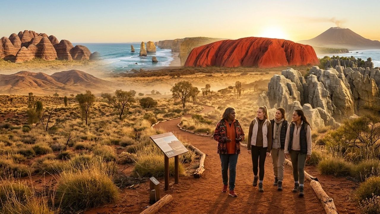
From the multi-billion-year-old continental shield of Australia to the hyperactive volcanic corridors of New Zealand, Papua New Guinea, and Fiji, monumental geological formations across the Southern Hemisphere are redefining international travel through deep-time geotourism and community-led conservation.
Across the Pacific and Australasian regions, natural monoliths, sea stacks, and eroded volcanic plugs offer travelers an extraordinary window into Earth's evolutionary history. Rather than treating these dramatic landscapes as mere backdrops for sightseeing photography, modern travelers are embracing geotourism—an interpretive approach that combines structural geology, geomorphology, and thousands of years of living Indigenous custodianship.
In Australia, ancient sandstones, granites, and coastal limestones reflect planetary stability spanning billions of years, protected through co-management models that honor Aboriginal songlines. Nearby, the collision zones of the Pacific Ring of Fire present a stark dynamic contrast: explosive andesitic stratovolcanoes in Papua New Guinea, marine limestone blowholes in New Zealand, and wind-sculpted magnetite dunes in Fiji. Understanding how these monuments were shaped—and how traditional owners preserve their spiritual and physical integrity—is vital for responsible expeditions into Earth's most remarkable wilderness areas.
SOUTHERN HEMISPHERE GEOLOGICAL MASTER ROSTER: PROFILES AT A GLANCE
| Entity / Facility | Delays | Cancellations | Details |
|---|---|---|---|
| Formation Name | Region & Country | Rock Classification | Scale / Elevation |
| Uluru | Northern Territory, AUS | Arkose Sandstone | 348m height (2.5km depth) |
| Kata Tjuta | Northern Territory, AUS | Conglomerate/Breccia | 546m height (36 domes) |
| Bungle Bungle Range | Western Australia, AUS | Quartz Sandstone | Up to 578m elevation |
| Twelve Apostles | Victoria, Australia | Miocene Limestone | Stacks up to 45m high |
| Ball's Pyramid | Lord Howe Island, AUS | Basaltic Sea Stack | 562m (World's tallest) |
| Pancake Rocks | South Island, NZ | Oligocene Limestone | 30m cliffs & blowholes |
| Mount Tavurvur | East New Britain, PNG | Andesitic Tephra | 688m active volcano |
| Hindenburg Wall | Western Province, PNG | Karst Limestone | 1,000m vertical wall |
| Sigatoka Sand Dunes | Viti Levu, Fiji | Magnetite Sand Dunes | Up to 60m dune crests |
| Sawa-i-Lau Caves | Yasawa Islands, Fiji | Karst Sea Limestone | Subterranean tidal caves |
The Geology of Deep Time: Two Contrasting Planetary Landscapes
The geological formations of the South Pacific and Australasia illustrate two diametrically opposed geological regimes: continental permanence versus tectonic turbulence.
TECTONIC ARCHITECTURE: AUSTRALIA CRATON VS. PACIFIC RIM
| Entity / Route | Metrics | Operational Status |
|---|---|---|
| Geological Dimension | Australian Continental Shield | Pacific Ring of Fire (NZ, PNG, Fiji) |
| Crustal Age | Archaean to Proterozoic | Cenozoic to Holocene |
| (Up to 3.8+ billion years old) | (Active uplift, millions of years) | |
| Dominant Processes | Aeolian abrasion, slow weathering, | Subduction volcanism, seismic uplift, |
| chemical dissolution, inselbergs | marine wave carving, hydrothermal | |
| Custodial Philosophy | Aboriginal Tjukurpa & Songlines | Māori Kaitiakitanga, Tolai Customary |
| (Deep-time ancestral stewardship) | Tenure, Fijian Vanua land ethics |
The Australian Shield: Stability, Erosion, and Inselbergs
Australia rests upon one of the oldest, most tectonically quiescent continental landmasses on the planet. Unbroken by major mountain-building collisions for hundreds of millions of years, the continent has been sculpted primarily by subaerial weathering, chemical leaching, and wind abrasion.
In this ancient environment, resistant rock masses emerge as inselbergs (island mountains) or residual tor networks. Sandstones laid down in shallow inland seas hundreds of millions of years ago, and granites cooled deep within ancient magma chambers, have been stripped bare of their surrounding softer strata, creating towering geological monoliths that anchor the desert interior.
The Pacific Ring of Fire: Volcanism, Subduction, and Karstification
In sharp contrast, the islands of New Zealand, Papua New Guinea, and Fiji sit directly astride active plate boundaries where the Pacific, Indo-Australian, and Philippine Sea plates grind together.
Here, geology operates on an accelerated timescale:
- Tectonic Subduction and Arc Volcanism: Oceanic crust diving beneath continental margins generates intense magma chambers, producing explosive stratovolcanoes and rhyolitic caldera systems.
- Marine Sediment Uplift: Coral reefs and offshore marine shells deposited during the Oligocene and Miocene epochs have been thrust thousands of meters above sea level by tectonic compression, where torrential tropical rainfall and heavy ocean swells carve vast karst caves, sinkholes, and vertical coastal cliffs.
Australia's Continental Monuments: Sandstone, Granite, and Coastal Limestone
Australia's vast landmass contains an outdoor gallery of monumental geology, spanning the central Red Centre, the southern coastal bluffs, and the remote northwestern Kimberley.
AUSTRALIA'S ICONIC ROCK FORMATIONS: REGIONAL GUIDE
| Entity / Route | Metrics | Operational Status |
|---|---|---|
| Landmark | State / Territory | Geological Formation Process |
| Uluru | Northern Territory | Tilted arkose sandstone strata of the Amadeus Basin |
| Kata Tjuta | Northern Territory | Alluvial conglomerate fans tilted during Alice Spgs |
| Karlu Karlu | Northern Territory | Spheroidal chemical weathering of granite pluton |
| Twelve Apostles | Victoria | Southern Ocean hydraulic compression of limestone |
| Remarkable Rocks | South Australia | Ordovician granite core shaped by wind & sea spray |
| Bungle Bungle Range | Western Australia | Devonian sandstone domes with cyanobacterial banding |
| Wave Rock | Western Australia | Flared granite slope carved by subsurface groundwater |
| The Pinnacles | Western Australia | Tamala limestone solution pipes exposed by deflation |
| Ball's Pyramid | Lord Howe Island | Heavily eroded shield volcano basalt sea stack |
| Three Sisters | New South Wales | Hawkesbury sandstone spires carved by cliff retreat |
1. Uluru: The Sacred Arkose Monolith
Rising 348 meters above the spinifex plains of the Northern Territory—and plunging an estimated 2.5 kilometers into the earth—Uluru is a monumental inselberg composed of Neoproterozoic arkose sandstone, rich in feldspar and quartz.
Deposited approximately 550 million years ago as an immense alluvial fan eroding from ancient mountain chains, the sandstone strata were tilted nearly 85 degrees vertically during the Alice Springs Orogeny. Today's visible monolith represents the resistant edge of these vertical rock slabs. Under clear desert skies, oxidized iron within the sandstone mineral lattice glows fiery red at dawn and dusk. During rare monsoonal cloudbursts, sheets of silver water plunge down sheer crevices into ancient base pools.
To the Aṉangu traditional owners, Uluru is a living cultural monument governed by Tjukurpa—the foundational legal and spiritual framework connecting people, ancestral beings, and the land. A permanent climbing ban implemented in October 2019 restored cultural dignity to the site, encouraging visitors to experience the rock through the 10.6-kilometer base walk, where ancient rock art shelters and ancestral stories are interpreted by Indigenous rangers.
2. Kata Tjuta: The Valley of the Winds
Located 30 kilometers west of Uluru, Kata Tjuta (traditionally meaning "Many Heads") comprises 36 domed conglomerates sprawling across more than 20 square kilometers, reaching an apex of 546 meters at Mount Olga.
Unlike Uluru's uniform sandstone, Kata Tjuta is formed from coarse sedimentary breccia and conglomerate containing granite, basalt, and quartzite boulders cemented by a fine sandstone matrix. Chemical weathering along vertical fracture lines over hundreds of millions of years gradually rounded the rock slabs into smooth, spherical domes. Kata Tjuta remains a deeply sacred ceremonial site for Aṉangu men, with public access carefully restricted to designated hiking routes, including the Valley of the Winds and Walpa Gorge trails.
ULURU VS. KATA TJUTA: GEOLOGICAL DIFFERENTIATION
+---------------------------------------+       +---------------------------------------+
|                 ULURU                 |       |               KATA TJUTA              |
|  - Uniform Arkose Sandstone           |       |  - Heterogeneous Pebble Conglomerate  |
|  - Single continuous inselberg block  |       |  - 36 distinct domed formations       |
|  - Tilted 85 degrees vertically       |       |  - Tilted 15-20 degrees gently        |
|  - Height: 348m above surrounding plain|       |  - Height: 546m (Mount Olga summit)   |
+---------------------------------------+       +---------------------------------------+
3. Karlu Karlu / Devils Marbles: Spheroidally Weathered Granite Tors
Situated in the arid interior of the Northern Territory, Karlu Karlu is a cluster of colossal granite boulders balanced precariously across a wide desert valley.
The formation process began millions of years ago when molten granite cooled deep beneath the surface. Horizontal and vertical cooling cracks divided the solid rock into rectangular blocks. Subsurface groundwater dissolved the feldspar along these joints, softening and rounding the corners of the blocks. When the surrounding topsoil was gradually stripped away by wind and rain, the rounded granite spheres were left exposed. Under intense desert temperature swings, concentric sheets of rock peel away like onion skins—a process known as thermal exfoliation.
Karlu Karlu holds spiritual significance for the Kaytetye, Alyawarre, Warlpiri, and Warumungu peoples, who associate the stones with ancestral dreaming paths and Rainbow Serpent traditions.
4. The Twelve Apostles: Southern Ocean Wave Mechanics
Along Victoria's dramatic Great Ocean Road, the Twelve Apostles demonstrate the unceasing erosive power of the Southern Ocean:
- Limestone Deposition: Approximately 15 to 20 million years ago, billions of tiny marine skeletal fragments settled on a shallow ocean floor, forming dense layers of soft Miocene limestone and calcarenite.
- Hydraulic Cliff Notch Formation: Continuous ocean swells exert hydraulic pressure against vertical joints in the coastal cliffs, carving hollow sea caves.
- Arch Collapse to Sea Stacks: As wave erosion deepens the caves, they breach through headlands to form natural arches. Over time, the center of the arch collapses under its own weight, leaving freestanding limestone stacks rising up to 45 meters above the surf.
- Continuous Evolution: The Apostles are dynamic, temporary structures. Originally known as the Sow and Pigs, nine stacks were recorded in the early twentieth century. Spectacular natural collapses in July 2005 and September 2009 reduced the primary offshore count to seven standing stacks, while ongoing headland erosion continues to carve new future pillars.
5. Purnululu National Park: The Beehive Domes of the Bungle Bungle
Tucked away in the East Kimberley region of Western Australia, the Bungle Bungle Range inside UNESCO World Heritage-listed Purnululu National Park represents one of the world's most extraordinary examples of cone-karst sandstone.
Formed during the Devonian Period approximately 360 million years ago, these beehive-shaped towers rise up to 578 meters above sea level. Their distinctive alternating orange and dark grey horizontal bands are biological and mineral wonders:
- Dark Grey Bands: Composed of dark cyanobacterial filaments that thrive on rock layers with high clay content, which retain moisture after the monsoon rains.
- Orange Bands: Layers of high-porosity sandstone that dry out too quickly for microbial growth, allowing iron oxide minerals to rust into a brilliant orange finish.
Managed jointly with the Gija and Karjaganujaru peoples, access is permitted strictly during the dry season (April to November), with visitors required to travel via four-wheel-drive along the rugged Spring Creek Track or observe the maze from scenic flights.
BUNGLE BUNGLE BANDING ARCHITECTURE
Sandstone Layer A (High Clay, High Moisture)   -> [DARK CYANIC BIOFILM]  (Grey Band)
Sandstone Layer B (Porose Quartz, Rapid Dry)   -> [OXIDIZED IRON MINERALS] (Orange Band)
Sandstone Layer A (High Clay, High Moisture)   -> [DARK CYANIC BIOFILM]  (Grey Band)
Sandstone Layer B (Porose Quartz, Rapid Dry)   -> [OXIDIZED IRON MINERALS] (Orange Band)
6. Ball's Pyramid: The World's Tallest Volcanic Sea Stack
Located 600 kilometers east of the Australian mainland in the stormy Tasman Sea, Ball's Pyramid rises 562 meters sheer out of oceanic depths from a base measuring only 1,100 meters long by 300 meters wide.
The stack is the erosional remnant of an ancient basaltic shield volcano that erupted 6.4 million years ago. Millions of years of relentless wave assault dismantled 97 percent of the original volcanic caldera, leaving only this razor-sharp spire.
Beyond its geological grandeur, Ball's Pyramid is a global conservation icon:
- Refuge of the "Tree Lobster": In 2001, Australian biologists scaling the stack's sheer basalt ledges discovered a surviving population of the Lord Howe Island stick insect (Dryococelus australis), a giant flightless invertebrate presumed extinct since 1920 due to black rats on the main island.
- Micro-Ecosystem Protection: The entire species survived on a single terraced ledge supporting a solitary Melaleuca howeana tea-tree shrub fed by underground rock seeps. Strict biosecurity regulations managed by the Lord Howe Island Board prohibit recreational landings on the stack, ensuring this fragile refuge remains undisturbed.
New Zealand's Dynamic Rim: Punakaiki, Volcanic Tuff, and Coastal Blowholes
Across the Tasman Sea, New Zealand's geology is youthful, active, and shaped by explosive volcanism, glacial movement, and rapid tectonic uplift along the Alpine Fault.
NEW ZEALAND GEOLOGICAL FORMATIONS: HIGHLIGHTS
| Entity / Route | Metrics | Operational Status |
|---|---|---|
| Site Name | Region | Geological Composition & Key Feature |
| Punakaiki Rocks | West Coast, South Is | Oligocene limestone stylobedding; marine blowholes |
| Cathedral Cove | Coromandel, North Is | Naturally hollowed marine arch in white rhyolite tuff |
| Castlepoint Reef | Wairarapa, North Is | Tilted fossiliferous limestone reef & lighthouse |
| Putangirua Pinnacles | Wairarapa, North Is | Severe badland erosion of ancient conglomerate gravel |
Punakaiki Pancake Rocks and Blowholes
On the rugged western margin of the South Island, the Pancake Rocks at Dolomite Point in Paparoa National Park present an extraordinary geological profile known as stylobedding:
- Marine Deposition: Thirty million years ago, alternating layers of calcareous marine fragments (shells, corals) and soft mud sediments accumulated on the seabed under tremendous hydrostatic pressure.
- Tectonic Uplift and Acidic Weathering: Alpine Fault tectonic movements lifted the seabed hundreds of meters into subaerial air. Rainwater containing weak carbonic acid dissolved the softer mudstone layers faster than the hard limestone, carving horizontal ridges resembling stacks of pancakes.
- Surge Blowholes: Deep horizontal caverns eroded into the base of the cliffs connect with vertical sinkholes. At high tide, powerful swells crashing into the caverns compress trapped air, violently expelling columns of sea foam dozens of meters into the sky with a thunderous roar.
The surrounding coastal rainforest is stewarded under the Māori principle of Kaitiakitanga (guardianship), with elevated boardwalks guiding visitors safely over fragile coastal cliff ecosystems.
Coromandel Peninsula: Cathedral Cove
Situated inside the Te Whanganui-a-Hei Marine Reserve on the North Island's Coromandel Peninsula, Cathedral Cove features a dramatic natural rock arch hollowed through brilliant white volcanic tuff.
Formed during the Miocene epoch by explosive caldera volcanism, the soft volcanic ash compacted into white rock. Over millennia, tidal currents and pounding waves systematically excavated weak joint lines within the headland, creating a soaring vaulted passageway linking two secluded white-sand bays. Access is carefully managed through coastal walking tracks to prevent vegetation erosion on adjacent volcanic cliffs.
Papua New Guinea: Volcanic Caldrons and the Great Hindenburg Wall
Papua New Guinea encompasses some of the most rugged, inaccessible geological formations on Earth, where the Pacific and Australian tectonic plates collide along the Bismarck Archipelago and the New Guinea Highlands.
PAPUA NEW GUINEA GEOLOGICAL FORMATIONS: HIGHLIGHTS
| Entity / Route | Metrics | Operational Status |
|---|---|---|
| Geological Feature | Province | Natural Phenomenon & Cultural Dimension |
| Mount Tavurvur | East New Britain | Active andesitic stratovolcano; geothermal springs |
| The Hindenburg Wall | Western Province | Colossal 1,000m vertical karst limestone escarpment |
| Muller Range Caves | Southern Highlands | Megakarst sinkholes and underground torrential river |
Mount Tavurvur: Living Volcanism in Simpson Harbour
Dominating the flooded caldera of Simpson Harbour near Rabaul in East New Britain, Mount Tavurvur is an active andesitic-dacitic stratovolcano:
- Historical Eruptions: Tavurvur erupted catastrophically in 1937, 1994, and 2014, depositing millions of tons of heavy volcanic ash that buried historic Rabaul town and reshaped the local coastline.
- Community-Led Geotourism: Local Tolai communities guide specialist travelers across solidified lava plains and bubbling geothermal sulphur vents. Tolai villagers explain how they adapt to active volcanic risk, utilizing the geothermal ground to harvest nutritious eggs from wild megapodes (incubator birds) that bury their clutches in hot ash.
- Scientific Vigilance: Travel to the volcano is regulated in coordination with the Rabaul Volcanological Observatory, ensuring that gas emissions and seismic tremors are continuously monitored.
The Hindenburg Wall: The Cathedral of Tropical Karst
In the remote Star Mountains of Western Province, the Hindenburg Wall rises as an immense, near-vertical limestone escarpment stretching for more than 50 kilometers and towering over 1,000 vertical meters above cloud-forested river valleys.
Formed from uplifted Miocene coral platforms, the wall is subjected to some of the highest rainfall totals on the planet (exceeding 8,000 millimeters annually). This intense precipitation drives rapid tropical karst dissolution, creating colossal sinkholes, bottomless vertical shafts, and uncharted underground rivers. The region is managed through customary land tenure systems, with local indigenous landowners balancing specialist scientific expeditions with rainforest conservation.
Fiji: Magnetite Dunes, Karst Caverns, and Ancient Pacific Heritage
Fiji's geological heritage links deep-time volcanic and coral development with more than three millennia of Pacific seafaring history.
FIJI'S REMARKABLE GEOLOGICAL LANDMARKS
| Entity / Route | Metrics | Operational Status |
|---|---|---|
| Site Name | Island Location | Geological Origin & Cultural Archaeology |
| Sigatoka Sand Dunes | Viti Levu | Magnetite coastal parabolic dunes; Lapita site |
| Sawa-i-Lau Caves | Yasawa Islands | Wave-dissolved limestone chambers & tidal pools |
| Joske's Thumb | Near Suva, Viti Levu | Eroded volcanic plug; exposed magma conduit core |
Sigatoka Sand Dunes National Park
Located on the southern Coral Coast of Fiji's main island, Viti Levu, the Sigatoka Sand Dunes constitute Fiji's first designated national park:
- Aeolian and Riverine Origins: Covering 650 hectares, the parabolic sand dunes rise between 20 and 60 meters above the roaring surf. The dunes were formed over thousands of years as heavy alluvial sediment containing heavy magnetite (iron-rich black sand) and quartz was washed down the Sigatoka River and driven back onto the coastline by strong southeasterly trade winds.
- The Lapita Archaeological Record: The shifting dunes protect invaluable archaeological treasures, including ceramic pottery shards, stone tools, and ancient burial grounds belonging to the Lapita culture—the original Austronesian navigators who colonized the southwestern Pacific 2,600 to 3,000 years ago.
- Custodial Management: Administered by the National Trust of Fiji alongside local village rangers, guided heritage trails educate travelers on dune ecology, migratory sea birds, and the importance of preserving ancient human remains from coastal foot traffic.
Sawa-i-Lau Limestone Caves: The Yasawa Sanctuaries
In the northern Yasawa Islands, towering karst limestone formations emerge dramatically from turquoise lagoons:
- Karst Dissolution: Over millions of years, rainwater mixed with soil acids dissolved subterranean voids within ancient uplifted reef limestone, while ocean wave action carved sea-level entrances into cathedral-like chambers.
- Cultural Lore and Saltwater Pools: Sawa-i-Lau's main cave is illuminated by natural sunlight filtering through an overhead limestone chimney, revealing a deep, crystal-clear saltwater pool. A second, darker chamber is accessible only by swimming underwater through a submerged rock tunnel during low tide. The caves are sacred in Fijian mythology, viewed as the resting place of ancestral deities.
Sustainable Geotourism: Protocols, Seasonal Windows, and Custodianship
Experiencing these ancient monuments responsibly requires travelers to balance geological curiosity with strict environmental and cultural ethics.
SUSTAINABLE GEOTOURISM BEST PRACTICE PROTOCOLS
| Entity / Route | Metrics | Operational Status |
|---|---|---|
| Focus Dimension | Mandatory Field Protocol | Purpose & Ecological Benefit |
| Path Preservation | Remain strictly on elevated | Prevents soil compaction, protects |
| boardwalks and marked tracks | micro-lichen & living stromatolites | |
| Indigenous Guidance | Book accredited traditional-owner | Ensures economic benefits remain with |
| and community-led excursions | local custodians; honors oral law | |
| Seasonal Adherence | Visit within designated dry-season | Avoids road erosion during monsoons; |
| operational windows | protects visitors from extreme heat | |
| Biosecurity Measures | Clean boots and hiking equipment | Stops spread of fungal pathogens like |
| before and after trail access | Phytophthora cinnamomi (dieback) |
Principles of Respectful Travel
-
Honoring Indigenous Land Governance:
- Understand that many geological formations are living spiritual sanctuaries. Always obey local prohibitions regarding sacred sites, drone operation, and sensitive rock art photography.
- Support Indigenous-owned enterprises (such as Maruku Arts in Uluru or Tolai cultural guides in Rabaul) to ensure your tourism expenditures directly sustain remote community schools, elder care, and cultural preservation initiatives.
-
Mitigating Biological and Chemical Damage:
- Never Touch Lichen or Stromatolites: Granite surfaces at Remarkable Rocks and Kangaroo Island are coated in orange Caloplaca lichens that grow at less than one millimeter per year; human touch strips these fragile colonies.
- At Hamelin Pool in Shark Bay, never step into the water or walk on marine stromatolites, as physical contact crushes delicate microbial mats that have survived for billions of years.
- Footwear Decontamination: Clean hiking boot treads between national parks in New Zealand and Australia to prevent spreading invasive weeds and deadly root-rot pathogens like Phytophthora cinnamomi.
-
Observing Seasonal Travel Windows:
- Central Australia (Uluru, Kata Tjuta, Karlu Karlu): Travel during the southern dry season from May to September, when daytime temperatures are mild (20°C to 25°C) and overnight freezes eliminate heatstroke risks. Summer temperatures routinely exceed 45°C, triggering trail closures at 11:00 AM.
- The Kimberley (Purnululu): Access is possible exclusively between April and November. Monsoonal rains between December and March submerge access rivers and wash out gravel tracks.
- Papua New Guinea and Fiji: Plan travel between May and October to avoid peak tropical cyclonic activity, excessive humidity, and heavy monsoon rainfall.
Frequently Asked Questions
What is geotourism, and how does it differ from conventional ecotourism?
Geotourism is specialized sustainable travel that focuses on the geological features, landforms, and deep-time processes of a landscape, while actively sustaining its ecological health and celebrating the living heritage and culture of local and Indigenous communities. Unlike conventional ecotourism, which primarily emphasizes wildlife and flora, geotourism explores the abiotic Earth systems (rocks, minerals, tectonics) that underpin all living ecosystems.
Why is climbing Uluru permanently prohibited?
Climbing Uluru was permanently closed in October 2019 out of respect for the Aṉangu traditional owners, for whom the monolith is an intensely sacred site governed by Tjukurpa ancestral law. Additionally, decades of climbing had caused severe physical erosion, left litter in sacred rock pools, and resulted in dozens of fatal accidents and injuries among visitors.
How did the Twelve Apostles in Victoria form, and why are there fewer today?
The Twelve Apostles formed over millions of years as fierce Southern Ocean swells eroded soft Miocene limestone cliffs into sea caves, then natural arches, and finally isolated freestanding stone stacks up to 45 meters high. Originally called the Sow and Pigs, there were nine primary stacks in the early 1900s; natural wave erosion caused two to collapse into the sea in 2005 and 2009, leaving seven standing today.
What causes the orange and black stripes on the Bungle Bungle domes?
The alternating horizontal bands on the Bungle Bungle sandstone towers in Purnululu National Park result from differences in clay content and moisture retention. The dark grey bands consist of microscopic cyanobacteria (blue-green algae) that grow on moist clay-rich layers. The orange bands are permeable quartz sandstone layers that dry out too quickly for microbial life, allowing iron compounds within the rock to oxidize (rust).
Is it safe for international tourists to visit Mount Tavurvur in Papua New Guinea?
Yes, provided visitors travel with accredited local Tolai guides and strictly obey safety advisories issued by the Rabaul Volcanological Observatory. Tavurvur is an active stratovolcano, and trained local guides monitor seismic activity, gas vent plumes, and weather conditions daily before leading small groups onto lower lava flows and geothermal zones.
What makes the stromatolites at Hamelin Pool in Western Australia so rare?
The stromatolites at Hamelin Pool in Shark Bay are living mineral structures built by microscopic cyanobacteria in hypersaline water twice as salty as normal seawater. They represent modern living analogues of Earth's earliest lifeforms dating back 3.5 billion years, which generated the oxygen that originally transformed our planet's atmosphere.
Related Travel Guides
- Poland and Emerging Destinations Reshape Europe's Winter Tourism: ETC Report Analyzes Surging 2026–2027 Travel Demand
- United States and Emerging Asian Markets Propel Philippines Tourism Past 5 Million Arrivals: 2026 Target Analysis
- US Strengthens Airline Passenger Rights Amid Ebola Travel Restrictions: DOT Refund and Voucher Mandates Explained
- Taiwan Entry Declaration Sparks Cross-Strait Tourism Controversy: Immigration Rules, Hotel Vouchers, and Traveler Guide
This article is for informational purposes. Flight routes, passenger regulations, visa rules, and transit advisories are subject to change by airlines and aviation authorities. Readers are advised to verify schedules and travel documentation with relevant carriers and border agencies before departure.
Related Stories
Tybee Island Holiday 2026: Festive Programming Drives Winter Tourism Surge in Coastal Georgia

Poland and Emerging Destinations Reshape Europe's Winter Tourism: ETC Report Analyzes Surging 2026–2027 Travel Demand