10 Best New Mexico Desert Road Trips Reddit Travelers Recommend in 2027

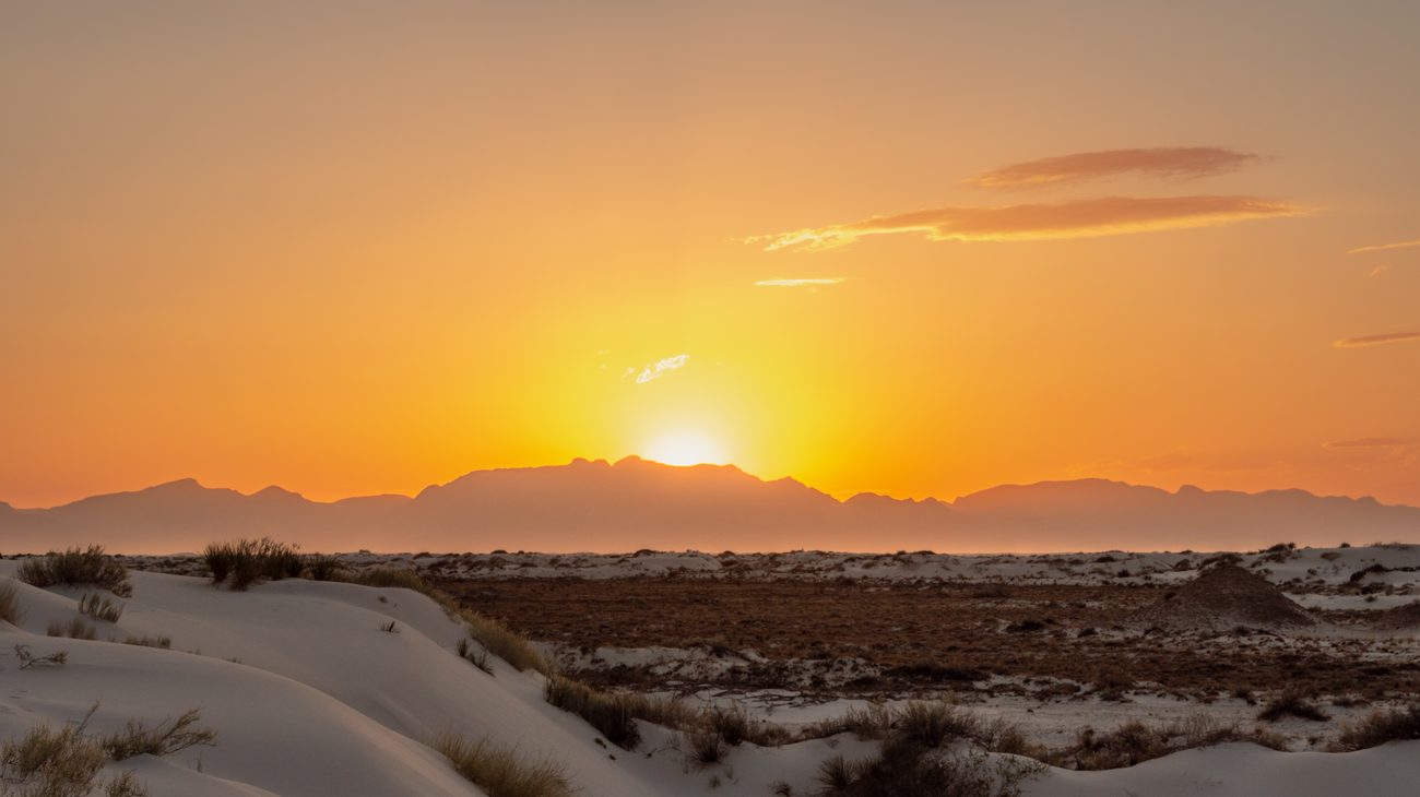
The otherworldly gypsum sand dunes of White Sands National Park glowing softly during twilight.
New Mexico does not reveal itself to travelers in a rush. If you stay on Interstate 40 or blast through Albuquerque on I-25, the landscape can appear deceptively stark—miles of pale creosote bush and dusty brown hills under an unforgiving sky. But the moment you veer onto two-lane desert asphalt, the Land of Enchantment shifts into an astonishing tapestry of layered crimson sandstone, pine-scented volcanic calderas, and centuries-old adobe chapels that feel older than the United States itself.
Over the past four years, I have logged thousands of miles across New Mexico's lonely desert highways, tracing roads that drop off the grid into remote badlands where wind and silence are your only companions. When you consult Reddit’s most seasoned road-trippers across r/NewMexico, r/roadtrip, and r/NationalPark, a distinct consensus emerges: the best desert journeys here demand curiosity, a tolerance for washboard dirt roads, and an appetite for roasted green chiles at roadside diners.
Planning an authentic 2027 Southwest adventure? Here are the 10 best New Mexico desert road trips Reddit travelers consistently recommend.
1. The White Sands & Tularosa Basin Loop (US-70 & NM-28)
- Route: Las Cruces → Organ Mountains → White Sands National Park → Alamogordo → Mesilla
- Distance: ~160 miles round-trip | Recommended Time: 1 to 2 days
Driving northeast out of Las Cruces along US-70, you climb aggressively through San Augustin Pass, where the jagged granite spires of the Organ Mountains frame the horizon like prehistoric teeth. As you crest the pass and descend into the vast Tularosa Basin, a shimmering white mirage appears against the desert floor: White Sands National Park, the world's largest gypsum dune field spanning 275 square miles.
Gypsum sand doesn't absorb solar heat like normal silica sand; you can kick off your hiking boots in the dead of summer and walk barefoot across silky, cool-to-the-touch waves. I hiked the 5-mile Alkali Flat Trail late in the afternoon, following red trail markers as the San Andres Mountains turned bruised shades of violet and crimson against the blinding white ridges.
- Reddit Pro-Tip: Do not leave the park immediately after sunset. r/NewMexico locals advise sticking around for the "blue hour," when the gypsum reflects lingering twilight into an unearthly cobalt glow. Before heading back, detour south along historic NM-28 through towering pecan orchards to the historic adobe plaza of Old Mesilla for stacked red-and-green chile enchiladas at La Posta de Mesilla.
- Travel Note: US-70 occasionally closes for up to 3 hours during missile tests conducted by the adjacent White Sands Missile Range; check road conditions before departing.
2. Bisti / De-Na-Zin Wilderness Alien Badlands (NM-371)
- Route: Farmington → NM-371 South → Bisti Access Road
- Distance: 75 miles round-trip from Farmington | Recommended Time: Full-day expedition
If you ever wondered what the surface of Mars would look like if it were carved out of coal shale and sandstone, drive south from Farmington along NM-371 into the Bisti / De-Na-Zin Wilderness. This 45,000-acre Bureau of Land Management expanse contains the most bewildering concentration of hoodoos, petrified wood logs, stone arches, and "cracked-egg" rock formations on the continent.
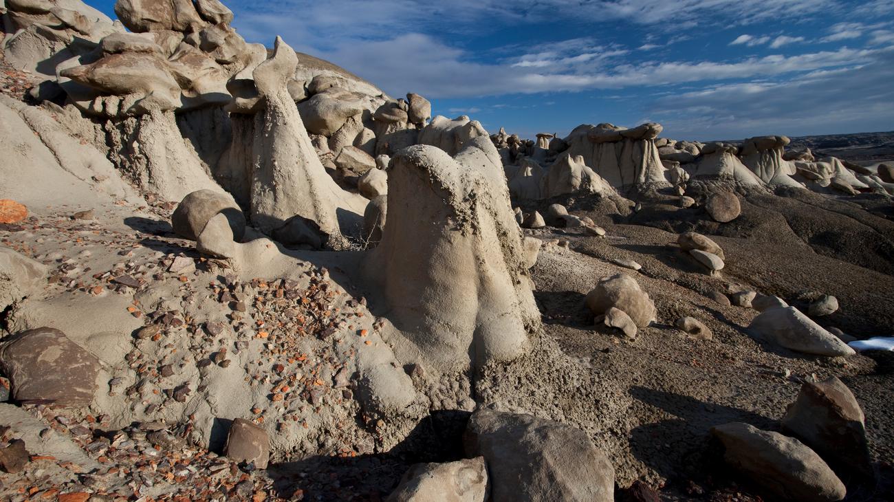
There are zero maintained trails, water sources, or visitor kiosks here. You leave your car at a gravel wash, cross a wire fence, and step directly into a 70-million-year-old prehistoric swamp turned stone labyrinth. Navigating with a pre-downloaded offline satellite track on Gaia GPS, I spent six hours weaving between mushroom-capped hoodoos that looked like petrified mythical beasts.
- Reddit Pro-Tip: Do not attempt to drive the Bisti access dirt road if it has rained within the past 24 hours. The bentonite clay turns into slick grease ("gumbo") that will swallow even high-clearance 4WD vehicles. Carry at least one gallon of water per person and bring an extra power bank for your navigation device.
3. The High Road to Taos Scenic Byway (NM-76 & NM-518)
- Route: Santa Fe → Chimayó → Córdova → Truchas → Las Trampas → Peñasco → Taos
- Distance: 105 miles one way | Recommended Time: 1 full day
While most tourists take the four-lane highway through Española, the true cultural heart of northern New Mexico beats along the High Road to Taos. This winding two-lane scenic byway climbs through piñon-studded high desert foothills into isolated mountain villages founded by Spanish colonists in the 17th and 18th centuries.
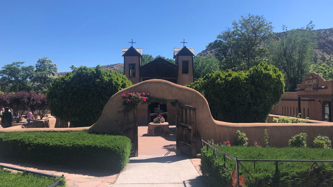
The defining stop is El Santuario de Chimayó, a low-slung 1816 adobe church revered across the Americas as the "Lourdes of North America." Inside the dimly lit sacristy, pilgrims leave behind crutches, rosaries, and prayers next to el pocito—a small hole in the dirt floor believed to hold miraculous healing earth. After kneeling in the cool adobe sanctuary, I walked across the creek to Leona’s de la Chimayó for warm, hand-rolled carne adovada burritos wrapped in fresh flour tortillas.
- Reddit Pro-Tip: Stop in Truchas (perched precariously along a razor-thin ridge overlooking the Sangre de Cristo range) to visit working woodcarvers and weavers. Take your time driving through Las Trampas to admire San José de Gracia Church, one of the finest surviving examples of pure Spanish colonial adobe architecture.
4. Carlsbad Caverns & The Chihuahuan Escarpment (US-62/180)
- Route: Carlsbad → Whites City → Carlsbad Caverns National Park → Sitting Bull Falls
- Distance: ~85 miles | Recommended Time: 1 to 2 days
Cutting through southeastern New Mexico, US-62/180 skirts the ancient Capitan Reef—a fossilized 250-million-year-old Permian barrier reef that now towers thousands of feet above the Chihuahuan Desert scrub. The main draw is hidden 750 feet directly beneath the desert surface: Carlsbad Caverns National Park.
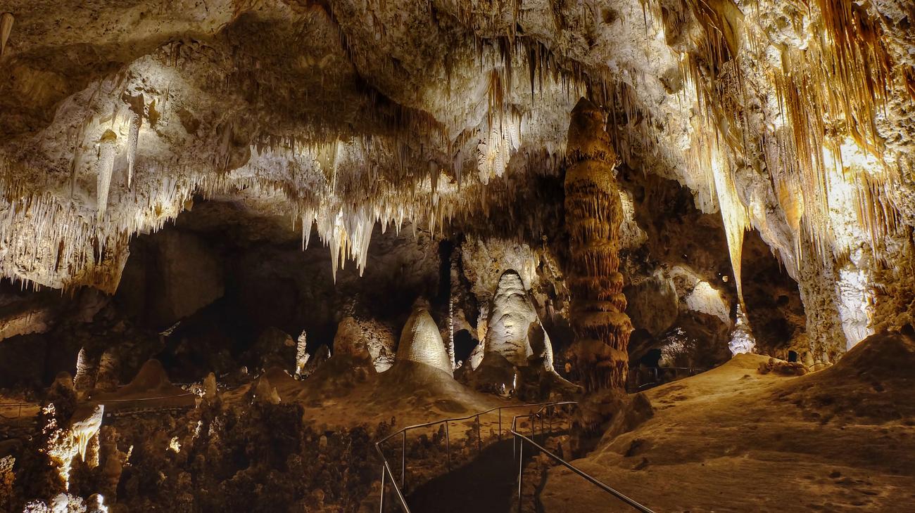
Skip the elevator on your way down. Walk the 1.25-mile Natural Entrance route through the gaping cave mouth; the air drops twenty degrees in minutes as you spiral into subterranean darkness that smells of damp limestone and bat guano. Reaching the Big Room—a cavern chamber large enough to fit six football fields under 250-foot ceilings—is a humbling reminder of nature's architectural grandeur.
- Reddit Pro-Tip: If visiting between late May and October, stay for the ranger-led Bat Flight Program at the outdoor amphitheater at dusk, where up to 400,000 Brazilian free-tailed bats spiral out of the cave entrance in a synchronized biological whirlpool.
- Side Trip: Take NM-137 into Lincoln National Forest to visit Sitting Bull Falls, a shocking 150-foot desert oasis waterfall fed by subterranean springs.
5. The Turquoise Trail National Scenic Byway (NM-14)
- Route: Albuquerque → Cedar Crest → Sandia Crest → Madrid → Cerrillos → Santa Fe
- Distance: ~65 miles | Recommended Time: Half-day to full day
Connecting Albuquerque and Santa Fe, NM-14 (The Turquoise Trail) hugs the backside of the Sandia Mountains, offering a scenic, unhurried alternative to Interstate 25. The route winds through historic mining camps that once supplied turquoise to pre-Columbian Puebloans and coal to steam locomotives.
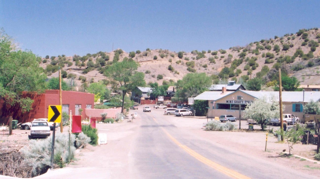
The highlight of the drive is Madrid (pronounced MAD-rid). Once a decaying coal ghost town in the 1950s, it was resurrected in the 1970s by artists, metalsmiths, and bohemians who converted company miner shacks into eclectic art galleries, indie jewelry workshops, and sculpture gardens. I stopped at the historic Mine Shaft Tavern, nursing a prickly pear cider while listening to acoustic blues on the wooden deck.
- Reddit Pro-Tip: Detour up NM-536 (Sandia Crest Byway) to the 10,678-foot summit of Sandia Crest. You'll enjoy an unobstructed, eagle-eye 11,000-square-mile panorama across the Rio Grande Rift valley and Jemez Mountains.
- Hidden Gem: Stop 3 miles north in Cerrillos, a dusty frontier town with dirt streets where movies like Young Guns were filmed. Visit the Mary’s Bar and the Cerrillos Hills State Park trails.
6. Georgia O’Keeffe Country & Ghost Ranch (US-84)
- Route: Española → Abiquiú → Ghost Ranch → Echo Amphitheater → Chama
- Distance: 90 miles one way | Recommended Time: 1 day
Driving north along US-84 past the village of Abiquiú, the landscape explodes into bands of apricot, cinnabar, and ochre cliffs that famously captivated painter Georgia O'Keeffe. *"Such a beautiful, untouched lonely feeling place, such a fine part of what I call the 'Faraway,'" * she wrote of this valley.
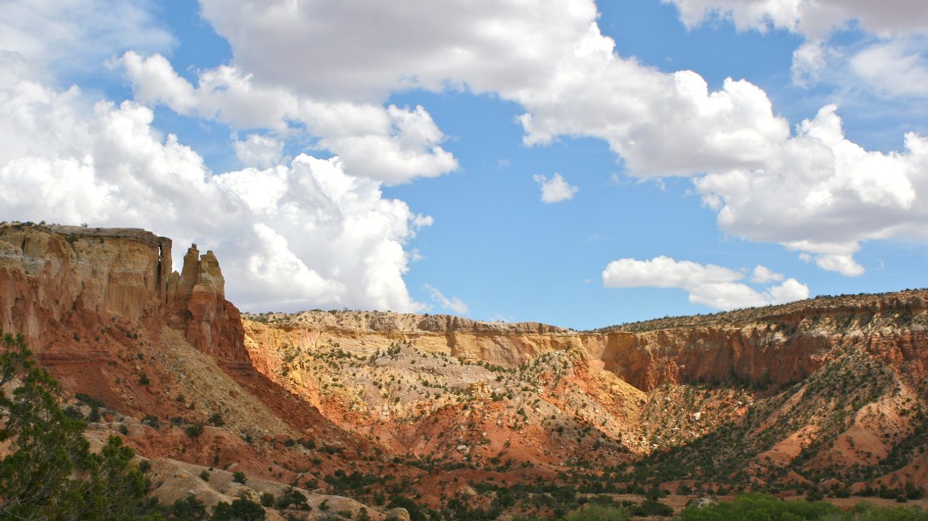
Turn into Ghost Ranch, an 21,000-acre education retreat center where O’Keeffe maintained a private residence. Lace up your boots for the Chimney Rock Trail (3 miles round-trip), which climbs 600 vertical feet through juniper and sage to a cliffside perch directly overlooking the flat-topped silhouette of Cerro Pedernal. The silence up here is palpable, broken only by the whistling desert wind and the occasional raven.
- Reddit Pro-Tip: Book a guided landscape tour of O’Keeffe’s painting sites at Ghost Ranch well in advance. Continue 4 miles north on US-84 to Echo Amphitheater, a naturally hollowed sandstone cliff face that amplifies sound across the canyon.
- Photography Time: Late afternoon (4:00 PM to sunset) when western sunlight ignites the red canyon walls into liquid gold.
7. Jemez Mountain Trail National Scenic Byway (NM-4)
- Route: San Ysidro → Jemez Springs → Valles Caldera → Bandelier National Monument → Los Alamos
- Distance: 132-mile loop | Recommended Time: 1 to 2 days
Starting at the desert crossroads of San Ysidro, NM-4 cuts through colossal red sandstone canyons before climbing into lush alpine forests surrounding the Valles Caldera National Preserve—a massive 13-mile-wide collapsed volcanic crater formed 1.25 million years ago.
The contrast on this drive is staggering. Within 45 minutes, you transition from arid desert hoodoos at Red Rocks to boiling sulfur hot springs in Jemez Springs, and then burst into high-altitude grassland valleys where herds of wild elk graze beneath 11,000-foot volcanic domes. The loop concludes at Bandelier National Monument, where ancestral Puebloans carved multistory cliff dwellings (cavates) into soft volcanic tuff canyon walls.
- Reddit Pro-Tip: Soak in the rustic outdoor mineral pools at Jemez Springs Bath House or hike a half-mile to the natural travertine terraces of Spence Hot Springs.
- Don't Miss: The dirt turnoff for the Gilman Tunnels, blasted through solid granite in the 1920s for logging trains over the rushing Guadalupe River gorge.
8. The Enchanted Circle Scenic Byway (NM-38, NM-522 & US-64)
- Route: Taos → Questa → Red River → Eagle Nest → Angel Fire → Taos
- Distance: 84-mile loop | Recommended Time: 1 day
Circling Wheeler Peak (New Mexico’s highest point at 13,161 feet), the Enchanted Circle is where the Chihuahuan desert ecosystem meets the southern tip of the Rocky Mountains. You begin among the sagebrush plains and 800-year-old adobe architecture of Taos Pueblo, climb through old gold-mining valleys in Red River, and cross high alpine meadows at Eagle Nest Lake.
Crossing the Rio Grande Gorge Bridge northwest of Taos on US-64 is a heart-stopping finale. Standing on the pedestrian walkway 650 feet above the churning Rio Grande river, with bighorn sheep balancing effortlessly on the rocky rim below, you understand why New Mexico is called the Land of Enchantment.
- Reddit Pro-Tip: Stop at the Vietnam Veterans Memorial State Park in Angel Fire, a striking white wing-like chapel perched on a hillside built in 1968 by a grieving father for his fallen son.
9. Geronimo Trail Scenic Byway & The Black Range (NM-152)
- Route: Truth or Consequences → Caballo Lake → Hillsboro → Kingston → Emery Pass → Silver City
- Distance: 115 miles | Recommended Time: 1 to 2 days
For drivers seeking true isolation away from the tourist corridors, NM-152 slicing through southwestern New Mexico is an unmissable challenge. Starting in the mineral hot spring haven of Truth or Consequences (T or C), the two-lane road skirts Caballo Lake before winding into the historic silver mining outposts of Hillsboro and Kingston.
Past Kingston, the highway climbs relentlessly through the Black Range via dozens of sheer hairpin curves up to Emery Pass (8,228 feet). The overlook offers staggering vistas dropping thousands of feet into the Gila National Forest wilderness. It is one of the quietest, most rugged drives in the American West.
- Reddit Pro-Tip: Book a private geothermal mineral soak at Riverbend Springs or Blackstone Hot Springs in T or C after the drive. The water emerges naturally at 104°F to 108°F right along the banks of the Rio Grande.
10. Chaco Culture Desert Pilgrimage (US-550 to CR-7900)
- Route: Bernalillo / Cuba → US-550 North → CR-7900 / CR-7950 → Chaco Canyon
- Distance: 150 miles from Albuquerque | Recommended Time: 1 to 2 days
Reaching Chaco Culture National Historical Park requires a deliberate pilgrimage across 21 miles of unpaved, deeply rutted washboard dirt roads in the arid San Juan Basin. But arriving at Pueblo Bonito—a massive four-story masonry great house containing hundreds of rooms aligned precisely with the solar and lunar solstices—is life-changing.
Constructed between 850 and 1150 AD, Chaco was the ceremonial and economic hub of the ancestral Puebloan civilization. Standing inside the Great Kiva of Chetro Ketl as the desert wind howls across sandstone canyon cliffs, you feel the profound spiritual gravity of the ancient Southwest.
- Reddit Pro-Tip: Check weather relentlessly. If rain is forecast, do NOT enter Chaco Canyon; the clay access road becomes impassable even for four-wheel-drive trucks, and tow truck rescues cost upwards of $1,000. Reserve campsites at Gallo Campground months in advance to witness Chaco's world-renowned Class-1 International Dark Sky star display.
New Mexico Desert Road Trips: Overview Table
| Road Trip Route | Highway | Key Highlights | Driving Time | Reddit Pro-Tip |
|---|---|---|---|---|
| White Sands & Tularosa | US-70 / NM-28 | Gypsum dunes, Organ Mtns, Mesilla | 1–2 Days | Stay for the post-sunset "blue hour" on the dunes. |
| Bisti / De-Na-Zin | NM-371 | Alien hoodoos, petrified wood | 1 Day | Offline GPS essential; never drive clay roads wet. |
| High Road to Taos | NM-76 / NM-518 | Chimayó church, Truchas weavers | 1 Day | Try Chimayó heirloom chile and hand-rolled tortillas. |
| Carlsbad & Escarpment | US-62/180 | Big Room cavern, Bat Flight | 1–2 Days | Walk down the Natural Entrance instead of the elevator. |
| Turquoise Trail | NM-14 | Madrid ghost town, Sandia Crest | Half-day | Cruise up to Sandia Crest for an 11,000-ft panorama. |
| Georgia O'Keeffe Country | US-84 | Ghost Ranch cliffs, Echo Amphitheater | 1 Day | Hike Chimney Rock Trail late afternoon for golden light. |
| Jemez Mountain Trail | NM-4 | Valles Caldera, hot springs, Bandelier | 1–2 Days | Take a scenic soak in Jemez Springs mineral pools. |
| Enchanted Circle | NM-38 / US-64 | Wheeler Peak, Rio Grande Gorge | 1 Day | Walk across Rio Grande Gorge Bridge to spot bighorn sheep. |
| Geronimo Trail & Range | NM-152 | Kingston ghost town, Emery Pass, T or C | 1–2 Days | End your day with a private riverside hot spring soak. |
| Chaco Culture Pilgrimage | US-550 / CR-7900 | Ancient stone cities, Pueblo Bonito | 1–2 Days | Avoid dirt access roads entirely during wet weather. |
Reddit Traveler Rules for Navigating the New Mexico Desert
- Hydration Is Non-Negotiable: Because New Mexico's desert sits at high elevations (often 4,000 to 7,500+ feet above sea level), the air is exceptionally dry. You will dehydrate twice as fast as at sea level without sweating noticeably. Carry at least one gallon of water per person per day in your trunk.
- "Red, Green, or Christmas?": When ordering food across New Mexico, you will inevitably be asked this question regarding your chile preference. "Christmas" gets you half red chile (earthy, slow heat) and half green chile (smoky, bright, pungent).
- Download Offline Maps: Cell reception vanishes completely between towns across northern and western New Mexico. Pre-download Google Maps or OnX Offroad maps before leaving Albuquerque, Santa Fe, or Las Cruces.
- Mind the Summer Monsoon Season (July–August): Afternoon thunderstorms build quickly over the mountains. Flash floods can transform dry arroyos into violent walls of water within minutes. Never attempt to cross flooded desert dips or park in dry washes.
Frequently Asked Questions
What is the best month for a New Mexico desert road trip?
October is universally regarded by r/NewMexico locals as the absolute best month. The summer monsoon rains have passed, daytime temperatures hover around a crisp 70°F, golden cottonwoods blaze along riverbanks, and the aroma of roasting green chiles fills every town. Late spring (April–May) is also pleasant, though spring winds can be strong.
Can I do these road trips in a standard sedan or rental car?
Yes! Nine of the ten routes featured on this list are fully paved state and federal highways accessible to any passenger car. The only exceptions are the unpaved wash access road into the Bisti Wilderness (accessible dry in any sedan, impassable wet) and the rough 21-mile dirt road into Chaco Canyon (best tackled with decent ground clearance).
Is it safe to road trip in remote New Mexico desert areas?
It is very safe, provided you practice basic desert preparedness. Keep your gas tank above a quarter full at all times (gas stations can be 50 to 80 miles apart), carry plenty of drinking water, dress in layers for dramatic 40°F day-to-night temperature swings, and stay on marked roads.
How many days are needed to experience New Mexico's top desert routes?
A classic 7-to-10-day itinerary allows you to combine the Turquoise Trail, High Road to Taos, Ghost Ranch, and Jemez Mountains in northern New Mexico, with a southern swing down to White Sands and Carlsbad Caverns.
More Cross-Country Road Trip Guides:
- 10 Best Route 66 Hidden Roadside Attractions Reddit Travelers Recommend in 2027
- 10 Best Great Lakes Circle Tour Stops Reddit Travelers Recommend in 2027
- 10 Best Michigan Upper Peninsula Waterfall Road Trip Stops Reddit Travelers Recommend in 2027
- 10 Best Keweenaw Peninsula Scenic Drives Reddit Travelers Recommend in 2027
This article is for informational purposes. Flight routes, passenger regulations, visa rules, and transit advisories are subject to change by airlines and aviation authorities. Readers are advised to verify schedules and travel documentation with relevant carriers and border agencies before departure.
Related Stories
10 Best Route 66 Hidden Roadside Attractions Reddit Travelers Recommend in 2027
10 Best Keweenaw Peninsula Scenic Drives Reddit Travelers Recommend in 2027: A Highway Guide to Michigan's Copper Country