South Asia Mountain Travel Alert: Nepal, Bhutan, India, and Sri Lanka Disclose Distinct Flood and Landslide Risks

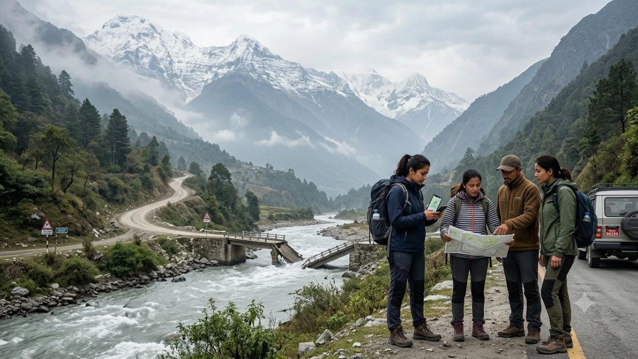
KATHMANDU / THIMPHU — Official disaster bulletins and infrastructure alerts across Nepal, Bhutan, India, and Sri Lanka have prompted renewed operational scrutiny of South Asian mountain travel corridors, revealing an operational environment where localized infrastructure damage—such as a washed-out motorable bridge in Nepal’s Gorkha district and a late-October glacial lake outburst flood in Bhutan—demands route-by-route verification rather than broad countrywide travel cancellations.
The emergence of concurrent mountain hazard notices across four nations has generated widespread confusion among international tour operators, trekking agencies, and independent travelers. However, comprehensive technical evaluations from national geological surveys, meteorological departments, and highway authorities confirm that these incidents represent separate, localized geological and hydrological events rather than a unified regional emergency.
From the Himalayan trekking trails of Gandaki Province to the tea-growing highlands of Sri Lanka’s Central Province, mountain travel safety requires understanding the specific differences between meteorological forecasts, geological hazard watches, and confirmed physical road closures.
By evaluating verified data at the district, corridor, and bridge level, outbound travel sellers and mountain expedition leaders can protect passenger safety, prevent unnecessary trip cancellations, and ensure that remote mountain communities continue to benefit from sustainable visitor spending.
       SOUTH ASIAN MOUNTAIN HAZARD REALITY: SEPARATE JURISDICTIONS

  NEPAL: Gorkha District (Aarughat Rural Municipality)
  - Physical bridge washout at Soti on Budhi Gandaki river route
  - Post-monsoon high-altitude snow warnings from Cyclone Arnab
  - Manaslu Circuit requiring lower-elevation approach diversions

  BHUTAN: Gasa & Punakha Dzongkhags
  - Sintaphu Glacial Lake Outburst Flood (GLOF) on 29–30 October
  - Satellite damage mapping of localized valley bridges and roads
  - Downstream alerts along the Pho Chhu river basin toward India

  INDIA: Himalayan Corridors & Northeast Transit
  - GSI baseline: 420,000 sq km mapped as landslide-prone terrain
  - Uttarakhand Char Dham pilgrimage routes clear on IMD nowcasts
  - Nagaland NH-702 local landslide diversion limited to light vehicles

  SRI LANKA: Central Highlands (7 Districts)
  - NBRI time-limited landslide bulletins (Yellow & Amber levels)
  - Localized slope saturation along tea estate roads in Nuwara Eliya
  - World Bank $110M climate-resilient road reconstruction program
The Operational Challenge: Granular Verification Versus Blanket Fear
The primary operational challenge facing the South Asian travel trade is the tendency to conflate distinct categories of risk. When international news outlets report landslides in the Himalayas or floods in South Asia, consumers frequently assume that entire countries have become impassable.
In reality, mountain topography creates hyper-localized risk profiles. A river valley experiencing an active flash flood may sit merely twenty kilometers from a parallel ridge trail operating under clear skies and stable ground conditions.
Similarly, an administrative landslide watch issued by a geological bureau alerts residents to soil moisture saturation, but it does not mean that every highway, mountain lodge, and scenic railway within that district has collapsed.
| Country | Primary Disaster Agency | Latest Verified Status | Operational Implication for Travelers |
|---|---|---|---|
| Nepal | Nepal Police / Nepal Tourism Board | Soti bridge washed out (Gorkha); Cyclone Arnab aftermath | Manaslu approach road closed; trekking detours required |
| Bhutan | Dept of Disaster Management / ICIMOD | Sintaphu Lake GLOF (Oct 29–30); valley bridge damage | Gasa and Punakha river crossings damaged; guides monitoring |
| India | IMD / Geological Survey of India | Char Dham nowcasts clear; Nagaland NH-702 diversion | Pilgrimage routes open; Northeast bypass restricted to cars |
| Sri Lanka | National Building Research Institute | Level 1 & 2 highland watches (Badulla, Nuwara Eliya) | Specific cut slopes unstable; scenic railways operating |
For ground handlers and independent explorers, the essential travel question is never whether an entire country is safe, but whether a specific itinerary possesses a verified approach road, stable bridges, authorized vehicle diversions, and a dependable emergency communication protocol if unexpected weather develops.
Nepal: Gorkha Bridge Washout and Post-Cyclone Mountain Realities
In Nepal, the primary infrastructure disruption centers on the lower approaches to the Manaslu Conservation Area. According to official operational bulletins issued by the Nepal Police at 09:00 on 5 November, the motorable bridge at Soti, linking Wards 2 and 3 of Aarughat Rural Municipality in Gorkha District, remains completely obstructed following catastrophic structural damage.
The underlying cause was an avalanche in the high Himalayas during late October that blocked a glacial tributary, creating a temporary natural dam. When the impounded water breached, the resulting surge down the Budhi Gandaki river system swept away the motorable span at Soti.
This bridge serves as an essential vehicular artery for off-road jeeps and supply trucks carrying provisions and trekking groups from Kathmandu to the traditional trailheads of Soti Khola and Machha Khola.
       NEPAL GORKHA & MANASLU TRANSIT INFRASTRUCTURE STATUS

  [ Kathmandu / Pokhara ]
            |
  [ Dhading Besi / Aarughat ]
            |
  [ SOTI BRIDGE (Aarughat Ward 2/3) ]  <=== FULL ROAD OBSTRUCTION (Bridge Washed Out)
            |
  [ Soti Khola / Machha Khola Trailheads ]
            |
  [ Jagat Checkpoint (Permit Control) ]
            |
  [ Namrung (Trail Reopened Sept 11) ]
            |
  [ Samagaun / Larkya La Pass (5,160m) ]
In response, the Nepal Tourism Board (NTB) issued a specialized travel advisory for the Budhi Gandaki corridor. The directive instructs licensed trekking guides and independent hikers to avoid flooded river crossings, maintain a safe buffer from unstable scree slopes, and coordinate with local rural municipality ward offices before attempting on-foot detours around the damaged bridge abutments.
This localized infrastructure failure must be distinguished from earlier route notices. On 11 September, the NTB confirmed that a separate landslide blockage near Namrung at higher elevations on the Manaslu Circuit had been cleared and the trail restored to full pedestrian use.
Concurrently, a separate NTB meteorological advisory issued in late October warned that the outer circulation of Cyclone Arnab had deposited unseasonal precipitation across Koshi, Bagmati, Madhesh, Gandaki, and Lumbini provinces, triggering temporary high-altitude snowfall and localized rockfalls above 4,000 meters.
Trekking agencies organizing expeditions over high passes—such as Larkya La (5,160m) on the Manaslu Circuit, Thorong La (5,416m) on the Annapurna Circuit, and Cho La (5,420m) in the Everest region—must obtain morning trail reports from local teahouse lodges and maintain direct contact with the Nepal Tourist Police via their nationwide emergency hotline (1144).
In tandem with trail-level verifications, international trekking operators must review aeromedical rescue protocols. The Trekking Agencies' Association of Nepal (TAAN) and the Nepal Mountaineering Association (NMA) work alongside the Civil Aviation Authority of Nepal (CAAN) to regulate high-altitude helicopter charter dispatches. When river bridges collapse or mountain landslides isolate trailheads, commercial rotorcraft become the primary lifeline for medical evacuations.
Travelers embarking on multi-week Himalayan treks must hold comprehensive travel insurance policies that explicitly cover non-emergency helicopter extraction and search-and-rescue operations up to 6,000 meters above sea level, ensuring that if trail blockages prevent return on foot, financial guarantees exist for aerial transfer.
Bhutan: The Sintaphu Glacial Flood and Valley Infrastructure
In the Kingdom of Bhutan, mountain hazards took the form of a rare, high-altitude hydrological event rather than standard monsoon landslides. On 29 and 30 October, a Glacial Lake Outburst Flood (GLOF) occurred at Sintaphu Lake, an alpine glacial basin situated in the rugged northern highlands of Gasa Dzongkhag.
According to technical data published by the International Centre for Integrated Mountain Development (ICIMOD), Sintaphu Lake held an estimated pre-outburst water volume of six to seven million cubic meters behind a moraine dam. When structural failure occurred, millions of cubic meters of water surged down the Mochhu and Pho Chhu river valleys, carrying glacial debris and boulders through Gasa and Punakha districts.
BHUTAN SINTAPHU GLACIAL LAKE OUTBURST FLOOD (GLOF)
| Column 1 |
|---|
| TRIGGER EVENT: |
| - Moraine dam failure at Sintaphu Lake (estimated 6–7 million m³ capacity) |
| - Rapid discharge down high-gradient Mochhu & Pho Chhu river systems |
| SATELLITE & INSTITUTIONAL RESPONSE: |
| - International Charter Space & Major Disasters activated on 31 October |
| - Preliminary satellite impact assessment delivered on 2 November |
| - Damage confirmed to localized valley roads, timber bridges & trail spans |
| - Downstream surge alerts monitored into India's Assam & West Bengal plains |
The International Charter Space and Major Disasters was officially activated on 31 October, producing preliminary satellite damage maps on 2 November. These radar and optical assessments confirmed damage to local secondary roads, pedestrian suspension bridges, and agricultural terraces along the river floor in Gasa and Punakha.
Fortunately, proactive civil protection measures significantly mitigated human risk. In September, the Bhutanese Ministry of Home Affairs had organized community-wide disaster evacuation drills in Punakha and Wangdue Phodrang, identifying high-ground muster zones, testing early warning sirens, and assigning evacuation roles to local authorities.
When the Sintaphu surge occurred, riverbank settlements and tourist facilities near Punakha Dzong received early alerts, allowing residents and international visitors to move to safety.
For travelers visiting Bhutan, the Department of Tourism emphasizes that the GLOF was a localized event confined to specific northern riverbeds. Iconic cultural landmarks—such as the Paro Taktsang (Tiger’s Nest), the capital city of Thimphu, and the central valleys of Trongsa and Bumthang—remain unaffected.
However, travelers booking trekking routes through Gasa, such as the famous Snowman Trek or Laya-Gasa Trail, must verify route passability with their mandatory licensed Bhutanese guides, as damaged footbridges along glacial river crossings may necessitate temporary route modifications.
The transboundary nature of Himalayan hydrology was underscored by downstream alerts issued by ICIMOD to Indian disaster management agencies. Water discharged from Bhutan's northern glaciers flows through the Sankosh and Manas river basins into the low-lying plains of Assam and West Bengal in India.
Bilaterally, Bhutan's National Center for Hydrology and Meteorology (NCHM) maintains continuous telemetry data sharing with the Central Water Commission (CWC) of India. When the Sintaphu outburst was detected, downstream hydrologic stations in Assam received early flood warnings hours before surge crests crossed international boundaries, allowing riverine wildlife safari operators in Manas National Park to adjust boat excursion schedules safely.
India: Distinguishing Historical Exposure from Daily Conditions
India presents a contrasting operating environment where immense historical hazard exposure exists alongside modern, real-time highway monitoring. According to the Geological Survey of India (GSI), approximately 420,000 square kilometers—representing 12.6 percent of India’s total land area, excluding permanently snow-covered peaks—is classified as prone to landslide activity.
Complementary spatial databases compiled by the National Remote Sensing Centre (NRSC) document roughly 80,000 historical landslides mapped between 1998 and 2022 across 17 states and two Union Territories.
       INDIA MOUNTAIN HAZARD FRAMEWORK: EXPOSURE VS. CONDITIONS

  HISTORICAL BASELINE (Geological Survey of India / NRSC Atlas):
  - 420,000 sq km mapped as landslide-prone terrain (12.6% of national territory)
  - 80,000 individual historical slope failures mapped across 17 states (1998–2022)
  - Concentrated in Western Himalayas, Eastern Himalayas & Western Ghats

  REAL-TIME PILGRIMAGE CONDITIONS (IMD Nowcast, 5 November):
  - Char Dham Pilgrimage Corridors (Uttarakhand): NO WARNINGS ACTIVE
  - Sikkim Himalayan Sub-division (5–11 November): NO WARNINGS ACTIVE
  - Clear weather across Kedarnath, Badrinath, Gangotri & Yamunotri
However, travel planners must avoid mistaking historical hazard mapping for current road closures. A region mapped as highly prone to landslides can remain completely safe and accessible during dry, stable weather conditions.
This distinction is illustrated in Uttarakhand. On 29 October, the Uttarakhand State Disaster Management Authority (USDMA) reviewed an orange meteorological forecast issued for five mountainous districts: Nainital, Champawat, Pithoragarh, Bageshwar, and Chamoli.
The disaster authority deployed heavy machinery for rapid debris clearance and monitored vulnerable slopes along the Char Dham pilgrimage routes leading to Kedarnath and Badrinath.
By 5 November, weather conditions had stabilized. The India Meteorological Department’s (IMD) official Char Dham Sector Nowcast showed no active weather warnings across any of the pilgrimage sectors. Similarly, IMD’s regional meteorological office in Gangtok issued a zero-warning outlook for Sikkim covering the entire 5 to 11 November window, indicating clear autumn skies for mountain travel.
                 NORTHEAST INDIA LOCAL TRANSIT DIVERSION

  Highway Obstruction:    National Highway 702 (NH-702) near Longleng, Nagaland
  Underlying Cause:       Slope failure blocking main carriageway
  Designated Diversion:   Tangha – Kangching – Merangkong Route
  VEHICLE RESTRICTION:    STRICTLY LIGHT VEHICLES ONLY (No Heavy Tourist Buses)
Nevertheless, local road disruptions require vigilance. In Northeast India, the district administration in Nagaland issued a formal traffic diversion following a slope failure that blocked National Highway 702 (NH-702) near Longleng.
The designated alternative—the Tangha–Kangching–Merangkong route—was strictly approved for light passenger cars only. Travel operators must recognize that a diversion suitable for a local four-wheel-drive vehicle or light taxi cannot accommodate heavy 35-passenger tourist coaches. Attempting to force heavy vehicles onto narrow rural diversions risks vehicle rollover and complete road blockages.
Sri Lanka: Highland Landslide Thresholds and Road Reconstruction
In Sri Lanka, mountain travel risks are managed through rainfall-triggered warning thresholds established by the National Building Research Institute (NBRI) in coordination with the Disaster Management Centre (DMC).
On 4 November, the NBRI issued a formal landslide early warning bulletin covering seven highland districts: Badulla, Kandy, Kegalle, Matale, Matara, Nuwara Eliya, and Ratnapura.
       SRI LANKA NBRI LANDSLIDE EARLY WARNING THRESHOLD SYSTEM

  [ Level 1: YELLOW WATCH ]  ----------------> Rainfall > 75mm in 24 Hours
  * Operational Meaning: Soil moisture rising; watch for slope failures & rockfalls
  * Travel Action: Exercise heightened vigilance along cut slopes & hillside roads

  [ Level 2: AMBER ALERT ]   ----------------> Rainfall > 100mm in 24 Hours
  * Operational Meaning: High saturation; slope instability likely if rain persists
  * Travel Action: Prepare for possible relocation; avoid parking under steep cliffs
  * Active Zones: Kotapola (Matara), Nildandahinna (Nuwara Eliya), Kalawana (Ratnapura)

  [ Level 3: RED EVACUATION ] --------------> Rainfall > 150mm in 24 Hours
  * Operational Meaning: Critical failure imminent; mandatory evacuation ordered
  * Active Zones: ZERO RED EVACUATION ZONES REPORTED IN CHECKED BULLETINS
The bulletin established Level 1 (Yellow) watches across divisions in Badulla, Kandy, and Kegalle, while Level 2 (Amber) alerts were declared for specific sub-divisions, including Kotapola in Matara, Nildandahinna in Nuwara Eliya, and Kalawana and Godakawela in Ratnapura. No Level 3 (Red) evacuation orders were issued.
For international travelers visiting popular hill-country destinations like Ella, Kandy, Nuwara Eliya, and the Horton Plains, these warnings require context. An amber alert indicates that steep, unreinforced roadside soil cuttings and narrow agricultural valleys require caution, but it does not represent a blanket closure of highland tourism.
The Main Line railway connecting Colombo to Badulla via the iconic Nine Arch Bridge in Ella and major resort hotels continued normal operations. In addition, the bulletin carried an explicit validity expiration of 16:00 on 5 November, reminding travel agents that expired bulletins must not be treated as evidence of ongoing closures without checking for updated releases.
The economic importance of resilient highland infrastructure is underscored by international financial investment. On 30 September 2026, the World Bank approved a US$110 million financing package to support the reconstruction of 600 kilometers of climate-resilient roads across Sri Lanka.
This program addresses lingering damage caused by Cyclone Ditwah in November 2025, which inflicted an estimated US$973 million in transport-sector losses, damaging nearly 2,000 kilometers of provincial roads, 3,500 kilometers of rural access ways, and almost 700 bridges.
By upgrading roadside drainage, constructing retaining walls along steep slopes, and reinforcing culverts, this multi-year initiative will improve the long-term reliability of Sri Lanka's tourism transit corridors.
For independent travelers navigating Sri Lanka’s central tea country during rainy spells, the island's rail infrastructure often provides an operational advantage over mountain roadways. Sri Lanka Railways deploys permanent track maintenance crews along the scenic Kandy-Nanu Oya-Ella line to inspect ballast beds and clearing rockfalls before scheduled passenger runs.
While heavy rainfall can trigger temporary railway speed restrictions that add thirty to forty-five minutes to journey schedules, traveling by blue passenger train through the high-elevation mist avoids the acute hazards of blind roadside mudslides and slippery mountain switchbacks that challenge road vehicles on steep descents toward Wellawaya and Galle.
The Five-Layer Information Gap: Why Travel Operators Misjudge Mountain Risk
The simultaneous alerts across Nepal, Bhutan, India, and Sri Lanka illustrate an information challenge in modern adventure travel: the gap between meteorological forecasts, geological risk models, and physical road passability.
THE FIVE-LAYER MOUNTAIN RISK ARCHITECTURE
| Column 1 |
|---|
| LAYER 1: METEOROLOGICAL FORECASTS (IMD, DHM Nepal, Sri Lanka Met Dept) |
| - Measures: Atmospheric pressure, precipitation probability, cyclone tracks |
| - Limitation: High rainfall does not guarantee a road closure |
| LAYER 2: GEOLOGICAL & HYDROLOGICAL ASSESSMENTS (GSI, NBRI, ICIMOD) |
| - Measures: Soil moisture saturation, moraine lake volume, slope shear stress |
| - Limitation: Identifies susceptibility, not immediate transport blockage |
| LAYER 3: HIGHWAY & POLICE ENFORCEMENT NOTICES (Nepal Police, Border Roads) |
| - Measures: Confirmed physical carriageway obstructions, bridge collapses |
| - Limitation: Tracks current state; may not predict dynamic clearing times |
| LAYER 4: TOURISM AUTHORITY GUIDELINES (Nepal Tourism Board, Bhutan Tourism) |
| - Measures: Trekking permit status, trail recommendations, guide mandates |
| - Limitation: Requires local teahouse verification for micro-trail segments |
| LAYER 5: EMERGENCY SERVICES & EVACUATION NETWORKS (DMC, NDMA, SAR) |
| - Measures: Helicopter landing zones, emergency shelters, hospital triage |
| - Limitation: Activated during crises; not designed for route planning |
When travel sellers rely solely on Layer 1 (a weather forecast predicting heavy rain), they risk canceling viable itineraries prematurely, inflicting financial hardship on local mountain communities. Conversely, relying solely on Layer 4 (an open trekking permit) while ignoring Layer 3 (a police notice confirming a bridge collapse) can trap travelers on an impassable riverbank without food or shelter.
Effective risk management requires synthesizing all five layers. A tour operator must verify that the weather forecast is manageable, that geological alerts do not mandate evacuation, that highway police confirm the road is physically passable, that tourism authorities authorize trail entry, and that local ground handlers have an emergency contingency plan if conditions deteriorate.
Essential Risk Management Strategies for Mountain Travel Operators
To maintain safe operations across South Asia’s mountainous regions, travel management companies, trekking operators, and independent travelers should adopt six structured risk-mitigation protocols:
- Conduct Corridor-Specific Route Audits: Never rely on national-level travel warnings. Confirm the operational status of every bridge, pass, and mountain spur along the planned itinerary with local highway police and park checkpoints within twelve hours of departure.
- Track Bulletin Issuance and Expiration Timestamps: Official landslide and weather bulletins carry strict validity windows. An amber warning that expired yesterday afternoon does not indicate an active emergency today; conversely, a morning clearance notice may be superseded by an afternoon flash flood update.
- Verify Vehicle Weight Restrictions on Diversions: When highway authorities establish detour routes around landslide zones, confirm whether the alternative route is restricted to four-wheel-drive light vehicles. Never divert heavy passenger coaches onto steep, unpaved village roads without explicit administrative authorization.
- Engage Local Community Networks: Maintain daily communication with local teahouse owners, river ferry boatmen, and resident trekking guides. Grassroots observers provide immediate ground intelligence regarding river water clarity, rising tributary levels, and small scree movements that indicate impending slope failure.
- Establish Clear Operational Decision Triggers: Define objective, non-negotiable thresholds for modifying itineraries. Agree in advance that if 24-hour rainfall exceeds 100 millimeters, if a river crossing rises above knee level, or if high-altitude snow obscures trail markers, the group will halt, retreat to a certified safe shelter, or activate alternative routing.
- Deploy Communication Redundancy: Cellular networks frequently fail in deep Himalayan valleys and highland gorges. Every trekking group and remote transport vehicle must carry satellite communication devices (such as Garmin inReach, Iridium handsets, or ZOLEO units) with verified subscription plans, ensuring direct contact with rescue coordination centers regardless of local infrastructure damage.
By grounding travel decisions in verified route intelligence, strict vehicle compliance, and proactive communication, the travel trade can navigate South Asia's mountain corridors safely, preserving traveler well-being while sustaining the vital tourism economies of the Himalayas and the central highlands.
Related Travel Guides
- Canada Ranked World's Safest Country for 2027 as US Travelers Prioritize Provincial Parks and Worry-Free Trails
- France and ASEAN Forge Landmark Partnership in Jakarta to Advance Sustainable Tourism
- Austria and Slovenia Alert Motorists to Heavy Karawankentunnel A11 Congestion Amid Dual-Tube Construction
- Spain Sustainable Tourism Accord: Seville, Benidorm, Calvià, and Lloret de Mar Partner with British Travel Industry
This article is for informational purposes. Flight routes, passenger regulations, visa rules, and transit advisories are subject to change by airlines and aviation authorities. Readers are advised to verify schedules and travel documentation with relevant carriers and border agencies before departure.
Related Stories
US Autumn Travel Alert: Dangerous Surf, Dense Fog, and Mountain Snow Threaten Tourist Routes
Guavate Pork Highway and Carite State Forest: 2026 Logistics Guide for Puerto Rico's Mountains