New Zealand Reopens Wairere Falls Track After 16-Month Safety Overhaul: Complete Waikato Hiking, Rockfall Mitigation, and Summer Trail Guide

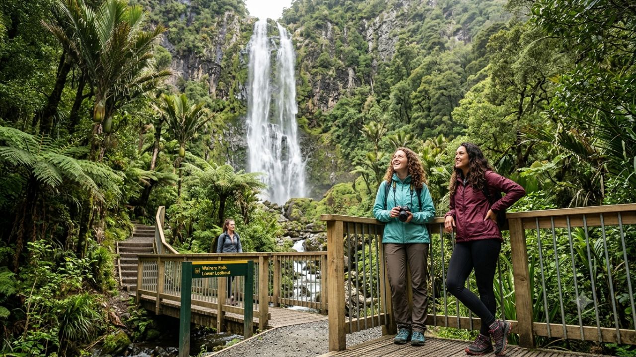
MATAMATA, New Zealand — The Department of Conservation (DOC) has officially reopened the Wairere Falls Track following an extensive sixteen-month geotechnical remediation and infrastructure overhaul, restoring public access to the North Island’s highest waterfall ahead of the southern hemisphere summer travel season.
Closed to the public since July 2025 due to severe rockfall hazards, deteriorating timber structures, and unstable volcanic escarpment cliffs, the famed Waikato walking trail reopened on 4 November 2026 after the completion of an intensive engineering program.
Standing at a commanding height of 153 meters (502 feet), Wairere Falls cascades over the rugged western precipice of the Kaimai Mamaku Conservation Park, drawing tens of thousands of domestic hikers, international eco-tourists, and landscape photographers each year.
The successful completion of the restoration project restores a cornerstone outdoor asset for the Matamata-Piako district, providing two distinct walking options: an accessible valley walk through native podocarp forest to the lower viewing platform, and an advanced, steep alpine ascent to the summit plateau overlooking the sweeping pastoral expanse of the Waikato Plains.
WAIRERE FALLS TRACK: TECHNICAL AND TRAIL SPECIFICATIONS
| Metric / Feature | Lower Lookout Trail | Upper Summit Lookout Trail |
|---|---|---|
| Total Waterfall Drop | 153 Meters (502 Feet) | 153 Meters (502 Feet) |
| Geographical Location | Kaimai Mamaku Park, Waikato | Kaimai Mamaku Park, Waikato |
| Trailhead Access | Goodwin Road, near Matamata | Goodwin Road, near Matamata |
| Return Distance / Time | 5.0 km / 1.5 Hours Return | 7.0 km / 3.5 to 4 Hours Return |
| Elevation Gain | ~150 Meters | ~400 Meters |
| Terrain Character | Forest path, bridges, rocks | Steep stairs, exposed roots |
| Difficulty Classification | Moderate Walking Track | Challenging Tramping Track |
| Managing Authority | Department of Conservation | Department of Conservation |
| Iwi Co-Management Partners | Ngāti Hinerangi, Ngāti Hauā, | Ngāti Hinerangi, Ngāti Hauā, |
| and Raukawa | and Raukawa |
The 16-Month Closure: Geotechnical Hazards, Rockfalls, and Escarpment Instability
The extended closure of the Wairere Falls Track was driven by genuine safety concerns rooted in the complex volcanic geology of the Kaimai Range.
In July 2025, regular monitoring by Department of Conservation rangers and geotechnical inspectors revealed accelerated erosion and boulder movement along the sheer rhyolite and andesite cliffs flanking the upper gorge. Decades of heavy orographic rainfall, thermal cycling, and seismic vibrations had loosened multi-ton basalt boulders situated directly above the main walking paths and viewing areas.
The Kaimai Mamaku Conservation Park occupies a steep geological boundary where ancient volcanic plateaus abruptly collapse toward the lowland agricultural plains of the Hauraki Basin and Waikato River catchment.
This dramatic escarpment creates the towering precipice necessary for the 153-meter waterfall, but it simultaneously produces an unstable rockfall environment. When large fragments detach from the upper rim, they gain immense velocity as they tumble down the near-vertical gorge, pulverizing sub-canopy vegetation and obliterating man-made infrastructure situated below.
Inspectors determined that several legacy structures along the track had reached the end of their operational lifespans.
The original upper viewing platform, constructed decades earlier on an exposed outcrop near the waterfall lip, exhibited structural timber fatigue and compromised footings. Intermediate staircases, retaining crib-walls, and pedestrian suspension footbridges crossing the swollen Waiwhero Stream had sustained progressive impact damage from shifting subsoil and falling debris.
Recognizing that an uncontrolled rockfall could cause catastrophic injury to visitors, DOC enacted immediate access restrictions, culminating in a total track and car park closure in September 2026 to facilitate intensive, uninterrupted engineering work.
                   GEOTECHNICAL HAZARD PROFILE: WAIRERE ESCARPMENT

   [ Kaimai Range Volcanic Plateau Rim (~400m Elevation) ]
                 |
                 +---> Intense Orographic Precipitation & Freeze-Thaw Weathering
                 |
                 v
   [ 153m Vertical Rhyolite/Andesite Escarpment ]
                 |
                 +---> Fractured Rock Masses & Unstable Talus Boulders
                 |     * High-velocity rockfall trajectories
                 |     * Sub-canopy impact zones
                 |
                 v
   [ Lower Gorge & Waiwhero Stream Bed ]
                 |
                 +---> Fluvial Erosion, Saturated Silt, Shifting Trail Footings
Geotechnical Remediation: Specialized Engineering on the Cliffs
Executing the restoration of the Wairere Falls Track required specialized engineering approaches, given that heavy earthmoving equipment could not access the roadless, protected wilderness terrain.
The Department of Conservation engaged specialized geotechnical contractors with high-angle rope-access certifications to execute hazardous rock-scaling operations across the vertical cliff faces. Suspended hundreds of feet above the valley floor on industrial safety lines, technical crews manually inspected fractures, pried loose high-risk rock masses, and anchored unstable boulders using high-tensile steel mesh systems and grouted rock bolts.
On the valley floor and intermediate slopes, construction teams replaced entire sections of degraded walking infrastructure.
A brand-new upper viewing platform was fabricated off-site using corrosion-resistant structural steel and sustainable hardwood decking, engineered to withstand extreme wind loading at the plateau edge. Helicopters were deployed to lift heavy steel frames, timber beams, and foundation piles into narrow forest clearings, minimizing ground disturbance and protecting delicate native understory plants.
In addition to the viewing platform, contractors rebuilt damaged river footbridges spanning the Waiwhero Stream, replacing rotting wooden spans with engineered steel-stringer bridges designed to resist seasonal floodwaters.
Crews also installed reinforced handrails, safety barrier netting along narrow precipice paths, and reconstructed hundreds of timber steps across steep ascents. Drainage channels and rock-armored culverts were installed to divert overland water runoff away from the trail surface, substantially reducing future erosion and slip risks during severe winter downpours.
INFRASTRUCTURE UPGRADE MATRIX: 2025–2026 OVERHAUL
| Entity / Route | Metrics | Operational Status |
|---|---|---|
| Component | Engineering Intervention | Operational Impact |
| Upper Viewing Platform | Complete demolition; installation of | Secure, cantilevered observation |
| engineered steel & hardwood deck | platform with high safety rails | |
| Cliff Face Stabilization | High-angle rope scaling, grouted | Drastic reduction in spontaneous |
| rock bolts, and containment mesh | boulder fall hazards along trail | |
| Waiwhero Stream Bridges | Replacement of aging timber spans | Flood-resilient footbridges with |
| with engineered steel-stringer units | non-slip grip mesh surfaces | |
| Staircases & Switchbacks | Reconstruction of timber box steps, | Improved ergonomics, reduced trail |
| stone risers, and safety handrails | braiding, and slip prevention | |
| Hydrological Drainage | Installation of stone-lined culverts | Diverts storm runoff to prevent |
| and cross-trail water diversion bars | tread washouts and deep mud holes |
The Two Walking Adventures: Choosing Between Valley and Summit
With the track officially reopened, visitors to the Matamata-Piako region have access to two distinct hiking itineraries originating from the Goodwin Road trailhead.
Both options showcase the natural splendor of the Kaimai Mamaku Conservation Park, but they demand vastly different levels of physical endurance, footwear, and route preparation.
                     WAIRERE FALLS TRAIL ROUTE ARCHITECTURE

   [ Goodwin Road Trailhead Car Park ]
                 |
                 +---> Initial Valley Section (Gentle gradient, lush forest, stream bridges)
                 |
                 v
   [ Lower Lookout Junction (~45 mins / 2.5 km from car park) ]
                 |
                 +---> Lower Viewing Platform: Direct panoramic view of 153m plunge
                 |
                 v (Steep Alpine Ascent: Steps, exposed tree roots, rocky switchbacks)
                 |
   [ Upper Summit Lookout (~1.5–2 hours from junction / ~400m elevation gain) ]
                 |
                 +---> Summit Edge: Water rushing over rim, sweeping Waikato Plains vista
1. The Lower Lookout: Accessible Family Forest Walk
The lower section of the Wairere Falls Track provides a rewarding, moderately paced walking experience suitable for families, casual tourists, and walkers with standard fitness levels.
Departing from the newly sealed Goodwin Road car park, the trail begins as a wide, well-formed pathway following the gentle upstream contours of the Waiwhero Stream.
Hikers are immediately immersed in a lush temperate rainforest ecosystem filled with ancient native trees. Towering pūriri, kohekohe, and rimu trees create an expansive forest canopy, while dense groves of nīkau palms and silver ferns flank the moss-draped riverbanks.
The sound of flowing water accompanies walkers as the trail crosses several small timber bridges, offering picturesque vistas of clear mountain water tumbling over granite and basalt boulders.
After approximately forty-five minutes of steady, gentle ascent over well-maintained steps and packed gravel trails, walkers arrive at the lower viewing platform.
Positioned directly opposite the lower third of the cataract, the platform provides an unobstructed view of the water as it plunges 153 meters down the mossy rock amphitheater into deep forest pools. The total round-trip journey to the lower lookout spans approximately five kilometers and takes between eighty and ninety minutes to complete, making it an ideal half-day excursion for visitors touring the central North Island.
2. The Upper Lookout: Demanding Alpine Tramp to the Plateau Rim
For experienced hikers and outdoor enthusiasts seeking an exhilarating physical challenge, the trail continues beyond the lower viewing platform toward the summit rim of the Kaimai Escarpment.
The character of the track changes dramatically once past the lower junction. The gentle forest path transitions into a rugged, steep tramping route that climbs nearly 400 vertical meters through dense sub-alpine forest.
Walkers must navigate a succession of steep wooden staircases, rock switchbacks, and networks of exposed tree roots that serve as natural stepping holds.
The physical exertion is intense, requiring cardiovascular stamina and steady balance across uneven, slick rock faces. As the elevation increases, the forest structure transitions from lush nīkau palms to sturdy montane hardwoods and dense stands of tawa and kāmahi.
Upon reaching the top of the escarpment, the trail emerges onto a solid timber boardwalk that winds through tranquil wetlands before arriving at the newly rebuilt cantilevered upper viewing platform.
The sensory transition is profound: standing safely behind engineered steel barriers, hikers look directly over the edge where the Waiwhero Stream sheets over the smooth volcanic precipice and drops into the void below.
To the west, the landscape opens into an astonishing panoramic vista stretching across the green patchwork of the Waikato Plains, extending toward the distant peaks of Mount Te Aroha and the horizon beyond. The full return journey to the summit lookout covers seven kilometers and requires between three and four hours of sustained hiking, with additional time needed during muddy or wet conditions.
TRAIL COMPARISON: LOWER LOOKOUT VS. UPPER SUMMIT
| Entity / Route | Metrics | Operational Status |
|---|---|---|
| Dimension | Lower Viewing Platform | Upper Summit Plateau |
| One-Way Distance | 2.5 Kilometers | 3.5 Kilometers |
| Estimated Return Time | 1.5 Hours | 3.5 to 4.5 Hours |
| Elevation Change | +150 Meters | +400 Meters |
| Trail Surface Quality | Packed gravel, timber boardwalks | Exposed roots, boulders, stairways |
| Recommended Footwear | Sturdy walking shoes or sneakers | High-ankle hiking boots with grip |
| Physical Demands | Moderate aerobic effort | Rigorous cardiovascular ascent |
| Prime Visual Asset | Frontal perspective of 153m waterfall | Edge-of-cliff view & Waikato vista |
| Child Accessibility | Suitable for active children | Demands close hand-in-hand control |
Māori Communities and Cultural Guardianship: The Iwi Partnership
The successful remediation and reopening of the Wairere Falls Track represents a significant achievement in bicultural conservation management in New Zealand.
The lands comprising the Kaimai Mamaku Conservation Park hold deep ancestral and spiritual importance for local Māori communities, specifically Ngāti Hinerangi, Ngāti Hauā, and Raukawa iwi.
Historically, the steep gully of Wairere Falls served as an essential ancestral overland pathway known as the Ara Wairere (the Wairere Trail).
Long before European arrival, Māori travelers utilized this rigorous mountain pass to traverse the formidable barrier of the Kaimai Range, transporting coastal goods, seafood, and obsidian from the Bay of Plenty (Tauranga Moana) to the inland settlements and fertile agricultural lands of the Waikato River valley. The waterfall and its surrounding catchment are recognized as wāhi tapu (sacred places), holding ancient stories, tribal burial grounds, and historical battle sites.
Throughout the sixteen-month safety overhaul, the Department of Conservation partnered closely with tribal elders and resource management representatives from Ngāti Hinerangi, Ngāti Hauā, and Raukawa.
Iwi representatives participated in site blessings, guided cultural impact assessments, and monitored construction crews to ensure that earthworks did not disturb sensitive cultural or ecological sites.
Before the public opening on 4 November 2026, tribal leaders led an early-morning traditional dawn ceremony (whakawātea), lifting spiritual restrictions (tapu) and invoking protection for all travelers who walk the mountain trails.
Officials from DOC and tribal authorities are currently developing bilingual cultural interpretation panels along the trail.
These installations will educate domestic and international visitors on the traditional Māori names of geographical features, indigenous botanical uses of native plants, and the enduring spiritual connection between the tangata whenua (people of the land) and the sacred waters of Wairere.
                    CULTURAL CO-MANAGEMENT ECOSYSTEM

   [ Department of Conservation (DOC / Te Papa Atawhai) ]
                 |
                 +<===> Joint Stewardship & Resource Protection
                 |
   [ Mana Whenua Iwi Authorities ]
         |
         +---> Ngāti Hinerangi (Ancestral guardians of Kaimai escarpment)
         +---> Ngāti Hauā (Guardians of western plains and river approaches)
         +---> Raukawa (Regional kaitiaki spanning historical trail networks)
                 |
                 v
   [ Tangible Outcomes on Wairere Track ]
         * Dawn Karakia and Whakawātea (Spiritual clearing ceremonies)
         * Cultural impact monitoring during high-angle geotechnical drilling
         * Future bilingual interpretive storytelling and heritage displays
Ecological Integrity: Kauri Dieback Prevention and Native Wildlife
In addition to its recreational appeal, the Kaimai Mamaku Conservation Park serves as an essential wildlife sanctuary protecting some of New Zealand’s rarest flora and fauna.
The prolonged track closure provided a temporary sanctuary for native species, allowing understory vegetation to regenerate without the pressures of heavy foot traffic.
                   KAIMAI MAMAKU BIODIVERSITY PROFILE

   [ Avian Wildlife ]
         * Kererū (New Zealand Pigeon): Essential seed-disperser for large native fruit
         * Tūī & Korimako (Bellbird): Nectar feeders providing vocal forest chorus
         * Pīwakawaka (Fantail): Aerial insect hunters accompanying hikers on trail
         * North Island Robin (Toutouwai): Ground-foraging endemic songbird

   [ Botanical Ecosystems ]
         * Lowland Canopy: Pūriri, kohekohe, rimu, and dense groves of nīkau palms
         * Montane Plateau: Tawa, kāmahi, hard beech, and sub-alpine moss gardens
         * Threatened Flora: Relict kauri stands on high ridges requiring strict biosecurity
A primary ecological imperative during the reopening is protecting native forests from Kauri Dieback Disease (Phytophthora agathidicida).
This deadly, soil-borne pathogen attacks the root systems of New Zealand’s iconic kauri trees, starving them of water and nutrients and causing irreversible mortality. While the lower Wairere gorge is dominated by broadleaf and podocarp forest, ancient kauri trees inhabit the ridges and upper plateaus of the Kaimai Range.
To safeguard these irreplaceable giants, DOC has installed specialized biosecurity wash stations at the Goodwin Road trailhead:
- Walkers are legally required to clean all mud and debris from their boots using stiff brushes before stepping onto the track.
- Hikers must step on spray grates that apply a specialized disinfectant solution (such as SteriGENE) capable of destroying microscopic pathogen spores.
- Visitors must stay strictly on the formed boardwalks and gravel pathways, as wandering off-trail compacts soil around sensitive tree roots and transports dormant spores into pristine forest compartments.
The forest surrounding Wairere Falls also supports thriving populations of native birds. Hikers frequently encounter bold pīwakawaka (fantails) flitting within inches of their path, feeding on insects disturbed by footsteps.
The deep, resonant chimes of tūī and korimako echo through the canopy, while large native kererū (wood pigeons) feed on ripe purple pūriri berries. In the damp rock crevices near the spray of the falls, nocturnal glow-worms illuminate the mossy cliff banks after sunset.
Critical Safety Protocols: Weather Risks, Flash Floods, and Rockfalls
While the Department of Conservation’s engineering work has greatly stabilized known hazard zones, the Wairere Falls Track traverses a wild, dynamic alpine environment where inherent natural dangers persist.
Visitors planning an excursion must adopt proactive safety precautions, particularly as New Zealand enters its unpredictable summer weather window.
NATURAL HAZARDS AND VISITOR RESPONSE PROTOCOLS
| Entity / Route | Metrics | Operational Status |
|---|---|---|
| Hazard Type | Contributing Factors | Recommended Action Protocol |
| Active Rockfall | Post-rainfall saturation, seismic | Move briskly through signed zones; |
| tremors, thermal rock expansion | never stop, picnic, or linger | |
| Flash Flooding | High-intensity orographic cloudbursts | Avoid stream crossings if water |
| over Kaimai plateau catchment | turns discolored or rises rapidly | |
| Hypothermia & Exposure | Rapid maritime weather changes, drop | Pack thermal layers, waterproof |
| in temperature with 400m elevation | shell jacket, and spare dry socks | |
| Slippery Terrain | Wet river boulders, greasy clay soils | Wear deep-lugged hiking boots; |
| polished by damp sub-canopy shade | utilize trekking poles for balance |
1. Rockfall Risk Zones
Hikers must understand that stabilizing a 153-meter rock face cannot eliminate every geotechnical risk.
Heavy rainfall acts as an environmental catalyst, penetrating deep fissures in the volcanic rock, increasing pore pressure, and washing away binding silt.
Visitors should observe the following guidelines:
- Never linger, rest, or consume food in signed rockfall hazard areas, particularly below the lower viewing platform or near vertical rock walls.
- If you hear the distinctive crack or rumble of falling stone, move immediately toward the uphill side of large trees or under solid rock overhangs rather than running blindly along the path.
- Avoid hiking the track during periods of heavy continuous rain or within twenty-four hours after an intense storm event.
2. Weather Volatility and Stream Dynamics
The Kaimai Range functions as a prominent meteorological barrier between the Bay of Plenty coast and the inland Waikato Basin.
Moist maritime air masses sweeping inland from the Pacific Ocean are forced upward over the escarpment, triggering sudden, localized orographic downpours that may not appear on regional weather forecasts for nearby Matamata.
A sudden thunderstorm over the plateau can transform the placid Waiwhero Stream into a roaring torrent within thirty minutes.
Hikers should monitor official weather warnings issued by MetService New Zealand. If stream waters turn muddy brown, carry floating tree branches, or rise over low-lying footings, hikers should turn back immediately rather than attempting to cross flooded sections.
                      HIKER EMERGENCY READINESS CHECKLIST

   [ Essential Personal Equipment ]
         * Robust hiking footwear with deep vibram-style rubber traction
         * Seam-sealed waterproof breathable rain jacket (Gore-Tex or equivalent)
         * Minimum 1.5 liters of potable drinking water per person
         * High-energy trail rations (nuts, dried fruits, energy bars)
         * Compact personal first-aid kit containing blister treatments and bandages

   [ Communications and Navigation ]
         * Fully charged mobile telephone (Note: cellular coverage is patchy in gorge)
         * Offline GPS mapping application (such as NZ Topo Maps or AllTrails)
         * Notification to a reliable emergency contact regarding planned return time
Regional Tourism Economics: Matamata, Waikato, and the Summer Surge
The reopening of the Wairere Falls Track arrives at a pivotal moment for the regional tourism economy of the Waikato and Matamata-Piako districts.
As international visitor arrivals to New Zealand climb toward historical records ahead of the December–February holiday peak, regional tourism operators are eager to diversify traveler itineraries beyond single-attraction day trips.
                   REGIONAL TOURISM SYNERGY NETWORK

   [ International Gateway: Auckland Airport (AKL) / 2 Hours Drive ]
                 |
                 v
   [ Matamata Heritage Hub: Hobbiton Movie Set Experience ]
                 |
                 +<===> High-yield overnight visitor retention
                 |
   [ Nature Hub: Wairere Falls Track (153m Waterfall & Alpine Tramp) ]
                 |
                 +<===> Dispersal into regional thermal & eco-destinations
                 |
   [ Regional Extensions: Te Aroha Mineral Spas & Karangahake Gorge ]
1. Synergies with Hobbiton and Cultural Attractions
Matamata is internationally celebrated as the filming location for the Hobbiton Movie Set, which welcomes hundreds of thousands of international guests annually.
Historically, however, a large proportion of these travelers visited Matamata on express tour coaches departing from Auckland or Rotorua, staying in town for only three to four hours before departing without patronizing local accommodation or dining establishments.
The reopening of Wairere Falls provides a world-class natural attraction located just fifteen minutes by road from central Matamata.
Tourism operators are packaging morning tours of Hobbiton with afternoon hikes to Wairere Falls, encouraging high-yield independent travelers to book overnight stays in local boutique bed-and-breakfasts, rural farmstays, and motels. This extended length of stay delivers direct economic dividends to local cafes, craft breweries, and regional transport providers.
2. The Port of Tauranga Shore Excursion Corridor
The proximity of Wairere Falls to the Port of Tauranga—New Zealand’s busiest cruise ship terminal—positions the waterfall as an appealing shore excursion destination.
Cruise travelers arriving on luxury liners often seek authentic outdoor adventures within a short transit window. Located approximately forty-five minutes west of Tauranga via State Highway 29 over the Kaimai Summit, Wairere Falls allows shore excursion operators to offer active hiking tours that return passengers well in advance of evening sailing deadlines.
REGIONAL DESTINATION HIGHLIGHTS & DRIVE TIMES
| Entity / Route | Metrics | Operational Status |
|---|---|---|
| Destination | Travel Time from Wairere | Primary Attraction & Tourism Value |
| Matamata Town Center | 15 Minutes (14 km) | Boutique dining, Hobbiton information hub |
| Hobbiton Movie Set | 25 Minutes (24 km) | World-renowned film set guided walking tours |
| Te Aroha Mineral Spas | 30 Minutes (32 km) | Natural historic soda water hot mineral spas |
| Tauranga / Mount | 45 Minutes (50 km) | Coastal beaches, cruise ship port, surf hubs |
| Maunganui (Bay of Plenty | ||
| Hamilton City Mega-Hub | 55 Minutes (65 km) | Hamilton Gardens, Waikato River, regional |
| international airport |
Legal Protections, Regulations, and Visitor Rights in New Zealand
International travelers visiting New Zealand enjoy statutory protections alongside strict environmental responsibilities governed by national legislation.
                     NEW ZEALAND VISITOR LEGAL FRAMEWORK

   [ Personal Injury Protection: Accident Compensation Corporation (ACC) ]
         * Comprehensive no-fault personal injury coverage for all visitors
         * Covers medical treatment, hospitalization, and emergency stabilization
         * Replaces civil litigation rights for personal injury claims

   [ Environmental Stewardship: Conservation Act & National Park Bylaws ]
         * Strict zero-litter policies; all waste must be carried out
         * Freedom camping prohibitions on non-designated conservation reserves
         * Prohibition of unauthorized drone operations over wildlife habitats
1. Accident Compensation Corporation (ACC) No-Fault Injury Cover
One of New Zealand’s most unique legal frameworks is the Accident Compensation Corporation (ACC).
Under the Accident Compensation Act, anyone injured in an accident within New Zealand—including international vacationers and temporary visa holders—is automatically covered by comprehensive, no-fault personal injury insurance.
If a hiker slips, sustains a fracture, or requires emergency wilderness search-and-rescue evacuation while traversing the Wairere Falls Track:
- Emergency medical stabilization, hospital treatment, and initial rehabilitation within New Zealand’s healthcare system are substantially funded by the state-managed ACC scheme.
- This coverage applies regardless of who caused the accident, eliminating the need to prove fault or negligence against government agencies or landowners.
- However, ACC does not replace private travel insurance; it does not cover overseas medical repatriation, missed connecting international flights, or lost travel gear. Visitors should maintain comprehensive international medical insurance policies.
2. Freedom Camping and Conservation Land Conduct
The Goodwin Road car park and the surrounding Kaimai Mamaku Conservation Park are subject to strict environmental protections under the Freedom Camping Act and the Conservation Act 1987:
- Overnight freedom camping in non-certified vehicles is strictly prohibited at the Wairere Falls trailhead. Violators face immediate statutory infringement fines of NZ$400 issued by local district council compliance officers.
- Travelers wishing to camp must utilize designated commercial holiday parks in Matamata or Te Aroha, or established DOC conservation campsites located throughout the wider Kaimai district.
- Operating recreational drones or unmanned aerial vehicles (UAVs) across the Wairere Falls Track without an approved commercial concession from the Department of Conservation is illegal. Drone flights disturb nesting native falcons (kārearea), create noise pollution, and infringe on the privacy of fellow trail users.
Practical Hiker’s Playbook: Step-by-Step Logistics for Visiting Wairere Falls
To ensure a seamless, safe, and enriching journey to Wairere Falls, travelers should structure their visit around proven field logistics.
WAIRERE FALLS EXPEDITION PLANNING PLAYBOOK
| Entity / Route | Metrics | Operational Status |
|---|---|---|
| Stage / Step | Recommended Operational Action | Practical Strategic Value |
| 1. Pre-Trip Check | Check DOC website & MetService alert | Verifies trail status and avoids |
| prior to departing accommodation | sudden severe storm fronts | |
| 2. Arrival Timing | Arrive at Goodwin Road car park | Secures parking space; avoids |
| before 09:00 AM or after 03:00 PM | peak midday summer congestion | |
| 3. Biosecurity Cleaning | Thoroughly scrub boots at trailhead | Prevents transmission of deadly |
| wash station with SteriGENE spray | microscopic Kauri Dieback spores | |
| 4. Pacing Discipline | Budget 90 mins for lower lookout, | Prevents exhaustion on steep |
| 4.0 hours for summit plateau tramp | upper staircases and rock scrambles | |
| 5. Post-Hike Recovery | Drive 30 mins north to Te Aroha | Soothes sore leg muscles in natural |
| Mineral Spas for therapeutic soaking | heated geothermal soda pools |
Step 1: Navigating to the Trailhead
The Wairere Falls Track is located at the eastern end of Goodwin Road, approximately fourteen kilometers northeast of Matamata.
From Matamata, travel north along State Highway 27, turn right onto Wardville Road, and continue onto Te Aroha-Gordon Road before turning onto Old Te Aroha Road and finally Goodwin Road. The access road is sealed throughout and suitable for all standard two-wheel-drive rental vehicles, campervans, and bicycles.
The car park features modern composting toilets, informative trail layout maps, and official DOC bulletin boards.
Step 2: Choosing Your Hiking Window
During peak summer months (December through February), the Goodwin Road car park fills quickly between 10:30 AM and 02:00 PM.
Independent travelers are encouraged to arrive early in the morning—ideally around 08:30 AM—to secure parking and enjoy the cool morning air under the forest canopy.
Early departures also offer the best light conditions for photographers, as the rising sun illuminates the eastern face of the waterfall without harsh midday glare.
Alternatively, late afternoon visits provide pleasant, shaded conditions for the lower lookout walk, though hikers attempting the upper summit must carry a headlamp in case their return takes longer than anticipated.
Step 3: Hydration and Trail Etiquette
There is no potable drinking water available along the trail or at the car park. Hikers must carry sufficient water for the entire return journey.
Water from the Waiwhero Stream should not be consumed untreated due to potential upstream agricultural runoff and naturally occurring waterborne protozoa such as Giardia.
On the trail, faster uphill trampers should be yielded right-of-way by downhill hikers on narrow stairways, ensuring smooth traffic flow along steep sections.
Step 4: Post-Hike Thermal Relaxation in Te Aroha
After completing the challenging four-hour summit trek, a highly recommended regional custom is driving thirty minutes north to the historic township of Te Aroha.
Nestled at the base of Mount Te Aroha, the town features historic Edwardian bathhouses fed by the world’s only natural soda water geyser.
Soaking in the warm, mineral-rich bicarbonate waters of the Te Aroha Mineral Spas provides natural muscular relief, easing soreness from hundreds of timber steps and concluding a classic Waikato wilderness adventure.
Strategic Horizons: The Future of Ecotourism in the Kaimai Escarpment
The successful reopening of the Wairere Falls Track demonstrates New Zealand’s ongoing commitment to balancing public access, geotechnical risk management, and indigenous cultural partnership.
By investing the capital, technical expertise, and collaborative goodwill required to execute a complex sixteen-month engineering overhaul, the Department of Conservation and its iwi partners have safeguarded a national treasure for generations to come.
As climate change accelerates weather extremes and winter storm intensities across the Pacific, maintaining outdoor infrastructure along active geological escarpments will demand continuous vigilance, ongoing geotechnical monitoring, and flexible trail management.
Yet, for travelers standing atop the newly rebuilt viewing platform—feeling the cool spray of the Waiwhero Stream as it launches into space above the tranquil green plains of the Waikato—the enduring power of New Zealand’s wild landscapes remains undiminished.
The reopening of Wairere Falls stands as a triumph of modern engineering and cultural respect, welcoming the world back to one of the most awe-inspiring natural wonders in Aotearoa.
Related Travel Guides
- Singapore Airlines Unveils S$2 Billion Cabin Revolution with Private First Class Suites, Sliding Business Doors, and Next-Gen Comfort on A350 and 777-9 Fleets
- EU Adopts Landmark Sustainable Tourism Strategy as Greece and Eight Global Partners Pioneer Reform
- Angola Courts Gulf Capital to Power Tourism Expansion as Portuguese Hospitality Enrolments Surge
- Mexico and Italy Transform Global Tourism Economics Through Multi-Year Wholesale Deals
- Best International Business Travel Networking Cities for Americans in 2026
This article is for informational purposes. Flight routes, passenger regulations, visa rules, and transit advisories are subject to change by airlines and aviation authorities. Readers are advised to verify schedules and travel documentation with relevant carriers and border agencies before departure.
Related Stories

Mount Fuji First Sunrise Flights 2027: Japan Airlines New Year Aerial Guide

Cambodia Beyond Angkor Wat: Etihad Airways and Tourism Board Travel Guide 2026