
Casper Solo Travel Guide: Mountain Trails, Pioneer History, and High-Plains Logistics in Wyoming
Perched at 5,150 feet in central Wyoming, Casper delivers an accessible solo travel alternative with 11 miles of river trails, mountain ridgelines, and pioneer landmarks.

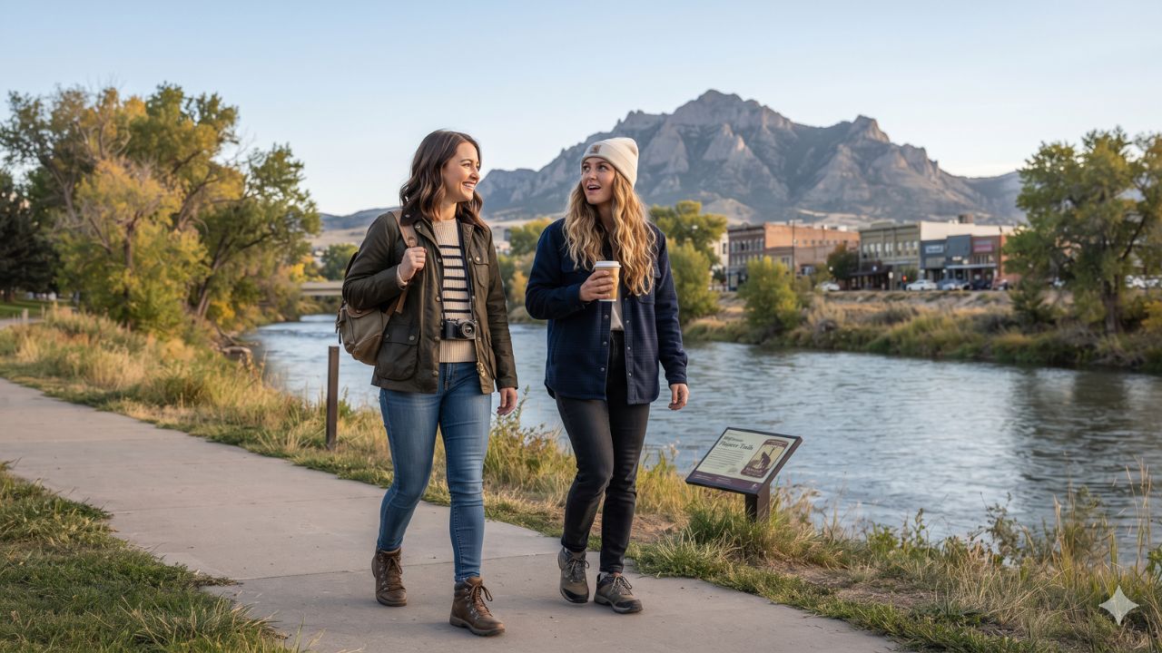
Anchored at an elevation of 5,150 feet along the North Platte River and situated just seven miles from commercial airline gates at Casper-Natrona County International Airport, Casper offers solo travelers an accessible alternative to overdeveloped Rocky Mountain resort towns. While solo expeditions across the American West frequently force visitors to choose between remote wilderness lacking safety infrastructure or expensive tourism enclaves, central Wyoming’s principal urban center balances both worlds. Independent travelers can spend the morning studying nineteenth-century overland trail records and local contemporary art downtown, dedicate the afternoon to hiking subalpine ridgelines, and finish the evening inside neighborhood craft taprooms.
Supported statewide by the Wyoming Office of Tourism and promoted regionally through Visit Casper, the city serves as a strategic crossroads where geography, Western frontier history, and outdoor recreation meet. By removing the logistical friction often encountered when planning solitary excursions across vast Western distances, Casper provides solo visitors the autonomy to establish their own pace across riverbanks, mountain pine forests, and historic pioneer corridors.
Urban Walkability and River Corridor Infrastructure: Navigating Downtown Casper and the Platte River Trail
Downtown Casper functions as the social and civic heart of Natrona County, presenting a dense, pedestrian-friendly core filled with historic brick facades, independent retailers, and regional dining. For travelers traveling independently, the neighborhood provides a secure, walkable base where accommodation, food, and cultural spaces sit within a five-block radius. The commercial center features specialty gear suppliers, traditional Western outfitters, artisan chocolatiers, and local coffee shops.
Public life converges at David Street Station, an open-air community plaza designed to host year-round seasonal gatherings, live music concerts, artisan craft markets, and outdoor community festivals. Surrounding this central commons, cultural seekers can explore contemporary regional art at the Nicolaysen Art Museum, an institution focused on Western visual culture and contemporary works, alongside Art 321, an accessible cooperative space showcasing community artists.
Extending directly from the urban perimeter into the surrounding river basin, the North Platte River forms the natural spine of the municipality. The city has developed this resource through the Platte River Trail, a continuously paved, multi-use greenway extending 11 miles through the community:
- Universal Year-Round Access: The trail remains completely free to the public throughout all four seasons, accommodating runners, road cyclists, walkers, and wildlife observers.
- Wayfinding and Safety: Clearly marked trailheads, interpretive historic panels, and integrated public sculptures create a structured environment where solitary visitors can exercise without navigational confusion.
- Riparian Ecology: Shaded by cottonwood groves along the riverbank, the corridor offers prime shoreline vantage points to watch fly fishermen casting for wild trout.
- Neighborhood Integration: Multiple access spurs link the paved greenway directly back to commercial streets, enabling visitors to break an 11-mile excursion into manageable morning walks followed by lunch downtown.
Subalpine Trails, Pioneer Heritage, and Regional Exploration
Rising immediately south of the municipal limits, Casper Mountain elevates the travel itinerary from valley floor to subalpine terrain within a 15-minute drive. Transitioning rapidly from sagebrush plains to dense ponderosa pine and quaking aspen groves, the mountain provides an all-season playground for hiking, gravel cycling, snowshoeing, and Nordic skiing.
Outdoor excursions frequently commence at Rotary Park, home to Garden Creek Falls, a cascading mountain landmark framed by sheer rock walls. From the park base, the Bridle Trail winds upward across forested switchbacks, rewarding solitary hikers with sweeping panoramic vistas across the entire Casper basin below. Further up the summit plateau, the Casper Mountain Trails Center acts as an operational hub, providing heated public restrooms, fresh water refill stations, and trail maps outlining beginner to technical backcountry routes.
Beyond physical recreation, Casper preserves one of the most consequential chapters of North American continental migration. During the mid-nineteenth century, hundreds of thousands of emigrants journeyed through this river valley following the Oregon, California, and Mormon Pioneer trails. Today, dedicated museum institutions interpret this frontier migration with scholarly rigor:
| Site / Attraction Name | Primary Focus & Historic Significance | Visitor Facilities & Resources | Admission & Operational Notes |
|---|---|---|---|
| National Historic Trails Interpretive Center | Interactive exploration of Oregon, California, and Mormon trails; covered wagon simulations | Hands-on multimedia dioramas, river crossing displays, historical theater | Free admission; operated in partnership with the Bureau of Land Management |
| Fort Caspar Museum | Frontier military history, 1860s wooden fort reconstruction, transcontinental telegraph post | Historic stockade buildings, museum galleries, archaeological exhibits | Modest admission fee; situated on original fort grounds beside the North Platte |
| Tate Geological Museum | Paleontology, regional minerals, fossils, and the famous Dee the Mammoth skeleton | Working fossil preparation laboratory, viewing cases, geological shop | Free public admission; located on the Casper College campus south of downtown |
| Casper Mountain Trails Center | Gateway to subalpine hiking, mountain biking, snowshoeing, and Nordic skiing loops | Heated indoor restrooms, potable water refilling, trail network maps | Free public trail access; seasonal equipment rentals available locally |
| Platte River Trail Corridor | 11-mile paved greenway following the North Platte River through the urban footprint | Public art sculptures, educational plaques, benches, river access spurs | Free multi-use trail open daily; completely paved and pedestrian-friendly |
| David Street Station Plaza | Central downtown civic gathering space hosting community markets and music events | Outdoor splash pad, ice skating rink in winter, performance band shell | Free public entry; surrounded by local restaurants, breweries, and retail |
The National Historic Trails Interpretive Center, maintained in collaboration with the Bureau of Land Management, allows independent guests to grasp the staggering logistical realities faced by wagon trains crossing the North Platte River. Nearby, Fort Caspar Museum details the military installations that protected early communications networks, while the Tate Geological Museum at Casper College exhibits ancient fossils, mineral deposits, and mammoth remains from Wyoming's prehistoric epochs.
Expert Analysis: The Economics of Secondary Mountain Hubs, Altitude Logistics, and Solitary Transit
Casper illustrates an important economic shift in Western travel, offering independent travelers an affordable entry point into the northern Rockies.
For travelers booking this route, the direct consequence of Casper's secondary-market profile is exceptional price-to-value efficiency. In premier Rocky Mountain ski enclaves, solitary travelers routinely encounter lodging rates exceeding $350 per night, high restaurant surcharges, and costly parking mandates. In contrast, Casper provides full-service hotels and boutique lodgings at standard regional rates, allowing solo visitors to allocate their budgets toward guided river expeditions, outdoor gear rentals, and regional culinary exploration.
The pricing pressure this creates means independent travelers can experience world-class outdoor recreation without the commercial friction of elite resort economies. The city’s dining scene has matured in tandem with its recreation profile. Solo travelers can dine comfortably at casual steakhouses, sourdough bakeries, authentic Thai eateries, and craft beverage spots. Local breweries—including Frontier Brewing Company, Black Tooth Brewing, and Skull Tree Brewing—act as relaxed community living rooms where visitors can sample regional ales alongside locals. For craft spirit enthusiasts, Backwards Distilling Company provides small-batch liquors distilled right in Wyoming.
From a transportation and transit perspective, planning a solo itinerary requires deliberate logistical preparation:
- Commercial Aviation Access: Casper-Natrona County International Airport sits roughly seven miles northwest of the city center. Daily regional jet connections linking through Denver International Airport provide the primary national transit artery. Rental car counters, local taxis, and app-based rideshares operate directly from the terminal.
- Ground Mobility Demands: While travelers concentrating solely on downtown galleries and the Platte River Trail can navigate comfortably on foot, securing a rental vehicle remains essential for those wishing to hike Casper Mountain or take day trips toward historic Independence Rock and Alcova Reservoir.
- High-Altitude Acclimatization: With the city base situated at 5,150 feet and Casper Mountain reaching nearly 8,000 feet, low-altitude visitors must account for reduced atmospheric oxygen. Solitary travelers must maintain high hydration levels, apply sun protection under intense UV rays, and moderate physical exertion during their first 24 hours.
- Seasonal Thermal Fluctuations: Central Wyoming experiences rapid weather shifts. By November, average daily high temperatures reach 49°F (9°C), before dropping to overnight lows of 26°F (-3°C). Visitors hiking solo must carry insulated outer layers, pack portable phone chargers, download offline topo maps, and notify lodging staff of planned mountain routes.
Key Takeaways
- Strategic Geography and Elevation: Casper sits at an elevation of 5,150 feet along the North Platte River, offering quick transitions between urban walkability and mountain forests.
- Accessible Outdoor Infrastructure: Features the free, 11-mile paved Platte River Trail alongside multi-season hiking, biking, and snow trails at Casper Mountain Trails Center.
- Frontier Historical Heritage: Serves as a prime center for overland pioneer history through the National Historic Trails Interpretive Center and Fort Caspar Museum.
- Welcoming Food and Beverage Scene: Boasts community-focused gathering places, including David Street Station, local steakhouses, and regional craft breweries like Frontier, Black Tooth, and Skull Tree.
- Aviation and Transport Logistics: Located seven miles from Casper-Natrona County International Airport with daily Denver flights; a rental car is recommended for mountain and regional trail access.
FAQ: Casper Solo Travel 2026
Is Casper, Wyoming, safe and practical for solo travelers?
Yes. Casper offers a safe, compact downtown with walkable dining and lodging, alongside structured public outdoor amenities like the paved 11-mile Platte River Trail.
What commercial flights serve Casper, Wyoming?
Casper-Natrona County International Airport is located seven miles from downtown, offering daily commercial flights connecting through Denver International Airport.
Do I need to rent a car when visiting Casper alone?
A rental vehicle is highly recommended if you plan to explore Casper Mountain, Garden Creek Falls, Independence Rock, or Alcova Reservoir, though downtown itself is walkable.
What should travelers pack for Casper’s high elevation and climate?
Visitors should pack thermal layers for rapid temperature swings, durable hiking footwear, sunscreen, and refillable water bottles to stay hydrated at 5,150 feet.
Balancing the unhurried calm of its winding riverbanks with the untamed ridgelines of Casper Mountain, central Wyoming invites independent explorers to chart their own journey through the American West.
Related Travel Guides
Disclaimer
This article is for informational and educational purposes only. It does not constitute legal, financial, or professional advice. While we strive to provide accurate and up-to-date information, travel policies, regulations, and conditions change rapidly. Always verify information with official sources before making travel decisions. Nomad Lawyer makes no representations about the accuracy, reliability, completeness, or suitability of the information provided. Readers should consult qualified professionals for advice specific to their circumstances. The views expressed in this article are those of the author and do not necessarily reflect the views of Nomad Lawyer.
Raushan Kumar
Founder & Lead Developer
Full-stack developer with 11+ years of experience and a passionate traveller. Raushan built Nomad Lawyer from the ground up with a vision to create the best travel and law experience on the web.
Learn more about our team →