Oaxaca Puerto Escondido Highway: How the Barranca Larga–Ventanilla Tollway Is Transforming Mexico Coast Tourism

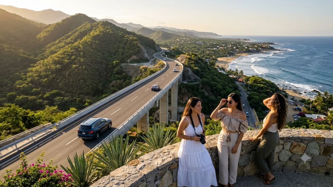
The 104.3-kilometer Barranca Larga–Ventanilla highway cuts journey times between Oaxaca City and Puerto Escondido from 6.5 hours to 2.5 hours.
OAXACA CITY, November 3, 2026 — The full operational integration of the Barranca Larga–Ventanilla highway is orchestrating a structural transformation across southern Mexico's tourism landscape, uniting the state of Oaxaca's colonial highland capital with its Pacific coastline. Engineered through some of the most rugged topography in the Sierra Madre del Sur, the 104.3-kilometer modern tollway represents a public infrastructure investment exceeding MXN 13 billion. By collapsing vehicular transit times between Oaxaca City and the coastal resort of Puerto Escondido from more than 6.5 arduous hours down to approximately 2.5 to 3 hours, the highway has resolved one of Mexico's most enduring geographical bottlenecks. The dramatic reduction in travel friction is catalyzing a new era of multi-destination travel, enabling domestic and international vacationers to seamlessly blend highland indigenous heritage, world-class gastronomy, and mezcal culture with world-renowned Pacific surfing, turtle conservation sanctuaries, and master-planned coastal bays.
[!NOTE] Key Infrastructure & Regional Tourism Parameters of the Barranca Larga–Ventanilla Highway: Spanning 104.3 kilometers, the modern highway includes 10 major bridges, three viaducts, three tunnels, and 15 interchanges developed with an investment exceeding MXN 13 billion. It slashes transit times between Oaxaca City and Puerto Escondido by roughly four hours. In 2025, the state of Oaxaca welcomed 6.29 million visitors, generating MXN 23.35 billion in economic activity. The highway establishes a rapid transit spine linking Oaxaca City with the Pacific Emerald Coast, including Puerto Escondido (41.52% average hotel occupancy in Jan–Aug 2025), Mazunte, Zipolite, and Bahías de Huatulco (62.86% hotel occupancy).
OAXACA TRANSIT CORRIDOR: HIGHWAY ROUTE & TRAVEL TIMES (BEFORE VS AFTER)
| Column 1 |
|---|
| [ HISTORIC MOUNTAIN ROUTES (FEDERAL HIGHWAYS 175 & 131) ] |
| * Transit Time: 6.5 to 8.5 hours of continuous mountain driving. |
| * Route Characteristics: Hundreds of tight hairpin bends, heavy fog, rockslides, motion sickness. |
| * Traveler Impact: Forced travelers to choose either highland culture OR beach relaxation. |
| [ THE BARRANCA LARGA–VENTANILLA TOLLWAY (HIGHWAY 107D) ] |
| * Transit Time: 2.5 to 3.0 hours at comfortable highway speeds (90-110 km/h). |
| * Time Savings: Approximately 4.0 hours saved per journey. |
| * Capital Investment: Exceeds MXN 13 billion (~$700M USD) under SICT federal supervision. |
| [ REGIONAL TOURISM BENEFICIARIES ] |
| * Oaxaca City: UNESCO Historic Center, Monte Albán, 7 Moles, Mezcal capital (6.29M visitors). |
| * Puerto Escondido: Zicatela Mexican Pipeline surfing, La Punta, vibrant coastal nightlife. |
| * Mazunte (Pueblo Mágico): Sea turtle conservation, holistic wellness, yoga, Punta Cometa. |
| * Zipolite: Mexico's premier clothing-optional beach, bohemian eco-cabins, alternative travel. |
| * Bahías de Huatulco: Master-planned sustainable resort bays, 5-star lodging, 62.86% occupancy. |
Civil Engineering Through the Sierra Sur: The 15-Year Infrastructure Breakthrough
The realization of the Barranca Larga–Ventanilla highway represents one of the most formidable civil engineering achievements in modern Mexican transportation history. Conceived initially in the late 2000s, the highway faced more than a decade of repeated delays, bankruptcies of private concessionaires, complex geotechnical complications, and delicate communal land rights negotiations with indigenous Zapotec and Chatino agrarian communities.
Supervised and brought to completion by the federal Secretariat of Infrastructure, Communications and Transport (SICT), the 104.3-kilometer tollway traverses the sheer vertical spine of the Sierra Madre del Sur. To establish a modern, two-lane highway with gentle gradients and wide paved shoulders, engineers constructed ten major reinforced-concrete bridges, three towering viaducts that span deep river canyons, and three specialized mountain tunnels.
The operational contrast between the new tollway and the historical routes it supersedes is immense. For over half a century, travelers journeying between Oaxaca City and the coast were forced to navigate either Federal Highway 175—which climbs through the cloud forests of Ixtlán and Miahuatlán before descending toward Pochutla—or Federal Highway 131 through Sola de Vega. Both legacy routes feature hundreds of relentless, narrow hairpin turns, steep unbarricaded drop-offs, and chronic seasonal vulnerability to landslides and washouts during the summer hurricane season.
What was once an exhausting, stomach-churning seven-hour endurance trial has been compressed into a safe, comfortable 150-minute drive. By bypassing dangerous mountain switchbacks, the new corridor allows private vehicles, regular scheduled express vans (colectivos), and commercial passenger buses to cruise smoothly at 90 to 110 kilometers per hour. For domestic Mexican families traveling from Mexico City, Puebla, or Querétaro, the Pacific coast of Oaxaca has suddenly transformed from a remote, hard-to-reach expedition into an accessible extended-weekend getaway.
DESTINATION PROFILES: OAXACA CITY TO THE PACIFIC EMERALD COAST
| Destination Hub | Core Identity & Appeal | Accommodation & Tourism Metrics |
|---|---|---|
| :--- | :--- | :--- |
| Oaxaca City | UNESCO colonial heritage, indigenous | 6.29 million total state visitors |
| (Central Valleys) | art, world-class gastronomy, mezcal | MXN 23.35 billion economic output |
| Puerto Escondido | Big-wave surfing (Zicatela), La Punta, | 41.52% average hotel occupancy; |
| (Coastal Gateway) | vibrant nightlife, international nomads | rapid expansion of boutique inns |
| Mazunte | Ecotourism, Mexican Turtle Center, | Eco-cabins, yoga retreats, |
| (Pueblo Mágico) | Punta Cometa spiritual sunsets, wellness | community-managed lodging |
| Zipolite | Open-minded, clothing-optional beach, | Bohemian beachfront palapas, |
| (Coastal Haven) | counter-culture charm, LGBTQ+ welcoming | relaxed independent guesthouses |
| Bahías de Huatulco | 9 protected bays, 36 beaches, national | 62.86% hotel occupancy; |
| (Resort Complex) | park coral reefs, sustainable luxury | 5-star all-inclusive properties |
The Inland Cultural Gateway: Oaxaca City's High-Yield Tourism Engine
Oaxaca City functions as the intellectual, artistic, and culinary heart of southern Mexico. Recognized as a UNESCO World Heritage site since 1987, the state capital is celebrated internationally for its impeccably preserved 16th-century green volcanic-stone (cantera verde) architecture, anchored by the magnificent Santo Domingo de Guzmán convent and the shaded open arcades of the central Zócalo.
The city's tourism appeal is anchored in its unparalleled cultural authenticity. Surrounded by the Central Valleys, Oaxaca serves as the gathering place for sixteen distinct indigenous ethnolinguistic groups, including the Zapotec and Mixtec peoples. Travelers flock to historic municipal markets—such as Mercado 20 de Noviembre and Mercado Benito Juárez—to immerse themselves in aromas of wood smoke, roasted cacao, dried chiles, and fresh herbs. Oaxaca's culinary reputation is globally celebrated, featuring the legendary seven varieties of mole (including Mole Negro and Mole Coloradito), tlayudas, artisanal string cheese (quesillo), and grasshopper snacks (chapulines).
Surrounding the urban center are globally significant archaeological and artisanal landmarks. The ancient Zapotec mountaintop capital of Monte Albán offers dramatic panoramic views over the valley, while nearby craft villages specialize in ancestral creative traditions: San Bartolo Coyotepec produces polished black pottery (barro negro), Teotitlán del Valle weaves vibrant wool rugs dyed with cochineal, and San Martín Tilcajete carves fanciful painted wooden spirit figures (alebrijes). Concurrently, the booming global appreciation for artisanal mezcal has turned the Central Valleys into an epicurean pilgrimage site, with travelers touring traditional small-batch palenques in Santiago Matatlán and Santa Catarina Minas.
According to official regional tourism data, Oaxaca welcomed 6.29 million domestic and international tourists in 2025, generating approximately MXN 23.35 billion in tourism-related expenditure. However, historically, a significant percentage of international cultural visitors departed Oaxaca City via direct flights back to Mexico City, unable or unwilling to commit an entire travel day to reach the Pacific coast by road.
The Barranca Larga–Ventanilla highway eliminates this geographical divide. Travelers can now curate balanced, high-yield vacation itineraries: spending three days exploring colonial art museums, botanical gardens, mezcal tastings, and pre-Columbian ruins in the temperate valley highlands, before embarking on a brief morning highway drive down to the tropical beaches of the Pacific.
PACIFIC COASTAL DYNAMICS: COMPARING OAXACA'S BEACH DESTINATIONS
| Column 1 |
|---|
| [ PUERTO ESCONDIDO: THE SURFING & BOUTIQUE LIFESTYLE HUB ] |
| * Global Surf Capital: Zicatela Beach hosts international competitions on 20-30ft shorebreaks. |
| * Urban Villages: La Punta (trendy dining, sandy streets), Carrizalillo (sheltered swimming cove). |
| * Occupancy Reality: 41.52% average occupancy reflects historical low-season softness. |
| * Highway Evolution: Shift from budget backpackers toward affluent weekend domestic vacationers. |
| [ MAZUNTE & ZIPOLITE: THE ALTERNATIVE & ECO-CONSCIOUS RETREATS ] |
| * Mazunte Sanctuary: Centro Mexicano de la Tortuga protects 5 marine turtle species. |
| * Punta Cometa: Westernmost point of Oaxaca, celebrated for panoramic sunset gatherings. |
| * Zipolite Freedom: Mexico's only legal clothing-optional beach, artistic palapas, LGBTQ+ safe. |
| * Sustainability Priority: Strict community bans on high-rise concrete construction. |
| [ BAHÍAS DE HUATULCO: THE MASTER-PLANNED SUSTAINABILITY STANDARD ] |
| * Environmental Benchmark: EarthCheck and Green Globe Platinum certified sustainable destination. |
| * Marine National Park: 9 pristine bays, 36 beaches, coral reef diving, protected mangroves. |
| * Commercial Strength: 62.86% hotel occupancy; robust charter flight links from US and Canada. |
Coastal Destination Realities: Puerto Escondido, Mazunte, Zipolite, and Bahías de Huatulco
The completion of the highway does not deliver a one-size-fits-all outcome for Oaxaca's coastline. Rather, it connects a diverse constellation of coastal communities, each possessing distinct demographic appeals, accommodation styles, and operational realities.
Puerto Escondido: Transforming the Surfing Capital into a Mainstream Powerhouse
Puerto Escondido is the immediate terminus and principal beneficiary of the new highway. Historically an isolated fishing village that gained international fame in the 1970s among adventurous surfers, the town is divided into several distinct neighborhoods. Playa Zicatela is renowned as the "Mexican Pipeline," producing massive, hollow sandbar barrels that attract elite surfers from across the globe. To the south, La Punta has evolved into a stylish, bohemian enclave of open-air cocktail bars, vegan cafés, and boutique hotels, while sheltered coves like Playa Carrizalillo and Puerto Angelito provide calm, turquoise waters for swimming and beginner surf lessons.
Despite its global social media fame, Puerto Escondido's hotel sector has historically operated below capacity. Between January and August 2025, the destination recorded an average hotel occupancy rate of approximately 41.52%. This relatively modest figure reflects deep seasonal fluctuations: while Christmas, New Year's, and Easter (Semana Santa) see properties fully booked, the town traditionally experienced severe occupancy drops during rainy shoulder months.
The Barranca Larga–Ventanilla highway is fundamentally altering this seasonal cycle. By making Puerto Escondido accessible for a Friday-to-Sunday road trip from Oaxaca City, the highway is generating an unprecedented influx of middle- and upper-class domestic visitors. Local hospitality operators are adapting rapidly, replacing rustic hostels with upscale boutique hotels, rooftop plunge-pool lounges, and fine-dining establishments highlighting coastal Oaxacan seafood.
Mazunte and San Agustinillo: Guarding the Ecotourism Sanctuary
Located forty-five minutes southeast of Puerto Escondido along coastal Federal Highway 200, the neighboring villages of Mazunte and San Agustinillo represent the ecological conscience of the Oaxacan coast. Mazunte is officially designated as a Pueblo Mágico (Magical Town), recognized for its commitment to environmental conservation and holistic wellness.
Mazunte's history is deeply inspiring. Formerly the center of Mexico's sea turtle harvesting industry, the community underwent a complete economic transition in the 1990s following a federal ban on turtle hunting. Today, Mazunte is home to the Mexican Turtle Center (Centro Mexicano de la Tortuga), an internationally acclaimed research and rehabilitation facility that protects nesting populations of Olive Ridley, Hawksbill, and Leatherback turtles. The village also supports a community-owned natural cosmetics cooperative, yoga ashrams, and silent meditation centers. Adjacent San Agustinillo offers a tranquil crescent beach lined with thatched-roof seafood palapas and small family-run eco-inns.
For Mazunte and San Agustinillo, the highway brings both economic promise and acute anxiety. The influx of day-trippers visiting Punta Cometa—a dramatic rocky peninsula celebrated as a sacred ceremonial site for sunset watching—has strained local pedestrian paths. Community assemblies are fiercely protective of their village character, actively resisting corporate commercialization and emphasizing low-impact, sustainable hospitality.
Zipolite: Preserving Bohemia on Mexico's Free Beach
Directly east of San Agustinillo lies Zipolite, a legendary destination in Mexican counter-culture. Spanning roughly one mile of golden sand pounded by powerful Pacific swells, Zipolite is officially recognized as Mexico's first and only legal clothing-optional beach.
Zipolite has maintained a relaxed, artistic, and fiercely independent atmosphere for decades. The destination attracts a diverse blend of European backpackers, naturists, artists, and LGBTQ+ travelers who appreciate its judgment-free ethos. Accommodation is predominantly intimate and independent, ranging from simple beachfront hammock spaces to stylish boutique properties constructed from local palm thatch, bamboo, and polished concrete.
The new highway provides Zipolite's independent hospitality sector with a steadier stream of domestic travelers. However, local operators emphasize that preserving Zipolite's distinctive spirit requires visitors to respect its open-minded culture, avoiding the intrusive commercial mass-tourism dynamics seen in major package resort corridors.
Bahías de Huatulco: The Master-Planned Sustainable Anchor
Situated at the southern end of Oaxaca's primary coastal tourism corridor, Bahías de Huatulco represents a completely different model of coastal hospitality. Master-planned by Mexico's National Fund for Tourism Development (FONATUR) in the 1980s, Huatulco encompasses nine pristine ocean bays and thirty-six sandy beaches, framed by the protected rainforests of Huatulco National Park.
Huatulco is recognized globally as an environmental benchmark, holding EarthCheck Platinum and Green Globe sustainability certifications. It features organized zoning, underground utility infrastructure, modern wastewater treatment plants that recycle 100% of municipal greywater for golf courses and gardens, and expansive low-density resort enclaves. During January–August 2025, Huatulco recorded an average hotel occupancy of 62.86%—significantly outperforming Puerto Escondido's 41.52%.
While the Barranca Larga–Ventanilla highway terminates near Puerto Escondido, travelers continuing along coastal Highway 200 reach Huatulco in an additional ninety minutes. The highway enables multi-destination coastal loops, allowing high-spending international travelers arriving at Huatulco International Airport (HUX) to explore Huatulco's luxury all-inclusive resorts, sample the eco-wellness of Mazunte, experience the surfing culture of Puerto Escondido, and drive up into the mountains to Oaxaca City before departing.
SOCIOECONOMIC CHALLENGES: BALANCING INFRASTRUCTURE WITH CONSERVATION
| Column 1 |
|---|
| [ WATER SCARCITY & MUNICIPAL UTILITIES ] |
| * Dry Season Stress: Coastal aquifers face depletion during peak winter tourist months. |
| * Infrastructure Deficit: Wastewater treatment plants need upgrades to protect marine reefs. |
| [ REAL ESTATE GENTRIFICATION & HOUSING PRESSURE ] |
| * Rising Land Values: Coastal property speculation pricing out local indigenous residents. |
| * Short-Term Rental Boom: Rapid conversion of residential apartments into digital nomad rentals. |
| [ ENVIRONMENTAL & BIODIVERSITY SAFEGUARDS ] |
| * Sea Turtle Nesting: Protecting Escobilla and Mazunte beaches from excessive night artificial light. |
| * Mangrove Preservation: Preventing coastal wetland infill near Manialtepec and Chacahua lagoons. |
| [ INDIGENOUS GOVERNANCE & COMMUNAL INTEGRITY ] |
| * Usos y Costumbres: Protecting traditional indigenous community decision-making assemblies. |
| * Sustainable Building Codes: Enforcing strict height limits and eco-architectural standards. |
Socioeconomic Transformation, Environmental Pressures, and Gentrification Challenges
The opening of a high-speed transit corridor through an ecologically fragile, culturally traditional region inevitably generates complex growing pains. While business federations celebrate enhanced accessibility, local municipal leaders, environmental scientists, and community activists are grappling with the unintended side effects of rapid tourism expansion.
Water Resource Strains and Municipal Infrastructure Limits
Foremost among coastal concerns is water security. Coastal Oaxaca experiences a pronounced dry season extending from November through May, coinciding precisely with the peak winter international tourism period. Coastal aquifers, fed by seasonal mountain rivers, face escalating pressure as thousands of new swimming pools, luxury villas, and boutique hotel suites come online.
In communities like Puerto Escondido and Mazunte, municipal water delivery systems are frequently overwhelmed during holiday peaks, forcing hotel operators to purchase expensive private water tanker deliveries (pipas). Environmental groups emphasize that without substantial, immediate public investment in modern wastewater treatment infrastructure, expanded municipal drainage, and rainwater harvesting systems, increased human waste could seep into local watersheds, threatening sensitive coral reefs and marine ecosystems.
Real Estate Speculation and Local Displacement
The anticipation and completion of the highway triggered an aggressive wave of real estate speculation across the Oaxacan coast. Over the past five years, land prices in prime beachfront areas—such as La Punta de Zicatela, Puerto Chino, and San Agustinillo—have escalated dramatically, attracting foreign developers, venture capital groups, and remote-work investors.
This property boom has exerted severe upward pressure on residential rents, making it increasingly difficult for local service workers, teachers, fishermen, and indigenous families to afford housing in their ancestral communities. The rapid conversion of long-term residential housing into short-term holiday rentals has intensified gentrification debates, prompting community assemblies to explore local zoning bylaws and rental restrictions to safeguard local residents from displacement.
Marine Conservation and Turtle Nesting Protection
The Oaxacan coastline is an ecological treasure of global significance. Beaches such as La Escobilla, located between Puerto Escondido and Mazunte, host monumental arribadas—synchronized mass-nesting events where hundreds of thousands of Olive Ridley sea turtles crawl ashore simultaneously to lay eggs under cover of darkness.
Environmental conservationists warn that unmanaged coastal development poses direct hazards to sea turtle populations. Artificial beachfront lighting from new hotels, beachfront night clubs, and restaurants can disorient hatchlings, leading them away from the sea toward fatal road traffic. In addition, increased vehicular traffic on coastal roads and boat traffic in coastal bays threatens migrating humpback whales, dolphin pods, and delicate mangrove estuaries such as Laguna de Manialtepec, famous for its nocturnal bioluminescence.
Maintaining strict environmental enforcement—including dark-sky lighting ordinances along nesting beaches, strict prohibitions on motorized off-road vehicles on sand dunes, and carrying-capacity caps on lagoon boat tours—is critical to ensuring that the natural attractions drawing travelers to the Oaxacan coast are not destroyed by their own success.
Comprehensive Master Analytical Matrix: Oaxaca's Tourism Corridor
The following analytical matrix summarizes the infrastructural parameters, primary attractions, accommodation dynamics, and strategic development priorities connecting Oaxaca City with the Pacific coast:
| Regional Hub | Altitude & Topography | Travel Time from Oaxaca City | Signature Tourism Appeal | Hotel Occupancy & Profile | Strategic Development Priority |
|---|---|---|---|---|---|
| Oaxaca City | 1,550m (Valley Highlands) | Starting Point / Gateway Hub | UNESCO colonial center, 7 moles, mezcal, Monte Albán | 6.29M annual statewide visitors; high international stay | Preservation of historic core; sustainable water management |
| Puerto Escondido | Sea Level (Pacific Coast) | 2.5 to 3.0 Hours (via Highway 107D) | Zicatela Pipeline surfing, La Punta nightlife, coves | 41.52% occupancy (2025); high seasonal fluctuation | Upgrading municipal water/sewage; regularizing airport taxis |
| Mazunte | Coastal Hills & Coves | 3.5 Hours (Highway 107D + Hwy 200) | Sea turtle center, yoga, eco-wellness, Punta Cometa | Eco-cabins, boutique retreats; low-impact capacity | Preservation of Pueblo Mágico character; waste management |
| Zipolite | Open Beachfront | 3.5 Hours (Highway 107D + Hwy 200) | Mexico's legal clothing-optional beach, counter-culture | Independent beachfront palapas; bohemian guesthouses | Protecting open-minded ethos; regulating shoreline development |
| Bahías de Huatulco | Coastal Lowlands & Bays | 4.0 Hours (Highway 107D + Hwy 200) | 9 protected bays, 36 beaches, National Park reefs | 62.86% occupancy; established sustainable resort base | Multi-destination marketing; expanding regional road loops |
The Strategic Roadmap: Sustainable Dispersal, Aviation Synergy, and the Isthmus Corridor
To harness the economic benefits of the Barranca Larga–Ventanilla highway while preserving Oaxaca's social and ecological balance, state tourism authorities, communal leadership, and private business federations are executing a coordinated development roadmap:
Linking Cultural Dispersal with the Interoceanic Corridor
The Barranca Larga–Ventanilla highway is part of a broader national infrastructure strategy transforming southern Mexico. To the east, the federal government is completing the modernization of the Mitla–Tehuantepec highway, which links Oaxaca City to the Isthmus of Tehuantepec and connects directly with the Interoceanic Railway of the Isthmus of Tehuantepec (CIIT).
When fully integrated, these highways will form a high-speed transit triangle across Oaxaca, connecting the Central Valleys, the Pacific Coast, and the Gulf of Mexico. This expanded connectivity allows tourism authorities to market comprehensive touring circuits that disperse travelers into lesser-known rural craft communities, coffee haciendas in the Pluma Hidalgo cloud forests, and indigenous Zapotec weaving villages, spreading economic prosperity far beyond the immediate beach strip.
Airport Synergy and International Direct Connectivity
Rather than competing with regional aviation, the new highway complements Oaxaca's airport network. Puerto Escondido International Airport (PXM) and Bahías de Huatulco International Airport (HUX) are both undergoing modernization programs.
With the highway operating smoothly, international airlines can market "open-jaw" or multi-city flight tickets: travelers can fly nonstop into Oaxaca City (OAX) from Houston, Dallas, or Mexico City, spend three days exploring the highlands, travel via the new highway to Puerto Escondido, enjoy coastal relaxation across Mazunte and Huatulco, and fly home directly from Huatulco Airport. This integrated road-and-air synergy eliminates backtracking, maximizes visitor vacation time, and stimulates multi-regional spending.
Empowering Communal Governance and Sustainable Building Codes
Oaxaca possesses a unique legal framework in which hundreds of municipalities operate under traditional indigenous customary governance systems (Usos y Costumbres). Communal land assemblies hold legal authority over local land use, natural resource allocation, and municipal development approvals.
State and federal planners are collaborating directly with communal assemblies in Santa María Colotepec, San Pedro Pochutla, and Santa María Tonameca to formulate clear, enforceable master development plans. By instituting strict three-story building height limits, mandatory setbacks from high-tide lines, strict rainwater catchment mandates, and architectural standards that incorporate local timber, stone, and traditional thatched roofing (palapa), the Oaxacan coast can avoid the sterile high-rise concrete commercialization that damaged competing resort regions, preserving its authentic, natural identity for generations to come.
Frequently Asked Questions About Oaxaca's New Coastal Highway
What is the Barranca Larga–Ventanilla highway and what route does it take?
The Barranca Larga–Ventanilla highway is a modern 104.3-kilometer toll road in southern Mexico connecting Oaxaca City with the Pacific coast near Puerto Escondido. It cuts directly through the Sierra Madre del Sur mountain range, bypassing the winding, mountainous legacy routes of Federal Highways 175 and 131.
How much travel time does the new highway save?
The highway reduces driving time from approximately 6.5 to 8.5 hours down to just 2.5 to 3.0 hours, saving travelers roughly four hours per trip and making weekend coastal getaways from Oaxaca City practical.
What are the main engineering features of the highway?
Constructed with an investment exceeding MXN 13 billion, the highway features ten major bridges, three viaducts spanning deep river canyons, three mountain tunnels, and fifteen interchanges that ensure smooth vehicular flow at speeds of 90 to 110 kilometers per hour.
Which coastal destinations benefit most from the new road?
The primary beneficiary is Puerto Escondido, the highway's direct coastal terminus. Secondary beneficiaries connected via coastal Federal Highway 200 include the ecotourism and turtle conservation sanctuary of Mazunte, the clothing-optional beach destination of Zipolite, and the master-planned sustainable resort bays of Huatulco.
What environmental and social challenges does the new highway create?
The rapid increase in visitor accessibility has intensified pressure on local coastal water supplies, generated real estate price inflation, strained municipal waste management, and raised concerns regarding sea turtle nesting habitat preservation. Local communities and indigenous assemblies are working to enforce sustainable building codes and protect natural resources.
Related Travel Guides
- Mexico Beach Tourism Slowdown 2026: Cancún, Tulum, and Cozumel Slump as International Air Arrivals Drop 9.9%
- Canada Inbound Travel from India Falls 7.8% in 2026: Gateway Analysis for Toronto, Vancouver, and Montréal
- Miami Leads Colombia Tourism as US Inbound Arrivals Fall 9.3% in 2026: Florida Gateways Face Shifting Demand
- US Inbound Tourism Slumps in 2026 as European Arrivals Plunge 7.3%: UK, Germany, and France Deficit Exceeds 500,000 Visitors
This article is for informational purposes. Flight routes, passenger regulations, visa rules, and transit advisories are subject to change by airlines and aviation authorities. Readers are advised to verify schedules and travel documentation with relevant carriers and border agencies before departure.
Related Stories
Mexico Beach Tourism Slowdown 2026: Cancún, Tulum, and Cozumel Slump as International Air Arrivals Drop 9.9%

Canada Inbound Travel from India Falls 7.8% in 2026: Gateway Analysis for Toronto, Vancouver, and Montréal