SPC Warns of Widespread US Tornado and Severe Weather Risk Threatening Major Travel and Tourism Disruptions Across the Plains and Midwest: New Travel Alert
The Storm Prediction Center issues a severe weather warning as supercell storms, tornadoes, and large hail threaten travel corridors in the Plains and Midwest.
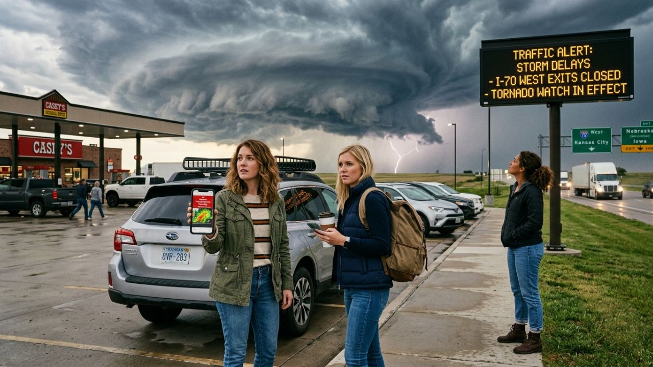
Image generated by AI
In a dramatic meteorological development that has put regional transportation and tourism networks on high alert, federal forecasters have issued a sweeping warning regarding a volatile atmospheric storm system. On May 18, 2026, experts raised alarms over an expanding US Tornado and Severe Weather Risk that is projected to disrupt travel across the central and eastern United States over the coming weekend and early next week. The intense storm system is expected to generate supercell thunderstorms capable of producing strong tornadoes, destructive wind gusts, and massive hail, threatening to impact major flight corridors, highway travel, and outdoor seasonal excursions from the Plains to the Midwest.
Quick Summary
- Official Alert: The Storm Prediction Center (SPC) has issued an Enhanced Risk of severe thunderstorms across the central Plains and Upper Midwest.
- Primary Hazards: Supercell storms capable of producing strong tornadoes, large to very large hail, and damaging wind gusts.
- Key States Affected: Kansas, Nebraska, Iowa, and Minnesota, with peak activity forecast for Sunday and Monday.
- Transportation Impacts: Flight delays, ground stops, and cancellations at regional hubs like Kansas City, Omaha, Des Moines, and Minneapolis.
- Road Travel Alert: Treacherous driving conditions, high winds, and flash flooding threats along Interstate corridors I-70, I-80, and I-35.
Crucial Details of the US Tornado and Severe Weather Risk
The Storm Prediction Center (SPC) has officially designated an Enhanced Risk of severe thunderstorms spanning the central Plains and stretching northward into the Upper Midwest. Meteorological models indicate that a cold front and extreme atmospheric instability are combining with moist, warm air surging northward from the Gulf of Mexico, creating ideal conditions for severe storm development. The high-risk forecast is most pronounced on Sunday and into Monday, with the severe weather threat expected to persist into the early workweek.
Forecasters warn that supercell thunderstorms—highly structured, rotating storms known for generating extreme weather—are highly likely to develop along drylines and frontal boundaries. The risk of tornadoes is elevated in areas where atmospheric wind shear and thermodynamic instability align. Detailed hazard charts show that parts of central Kansas and southeastern Nebraska are positioned in the higher-risk zones, where the potential for strong, long-track tornadoes is at its peak.
Direct Disruptions to Flight Operations, Roads, and Tourism
Because modern transportation networks are tightly integrated across state lines, severe weather of this magnitude carries a high potential to spark cascading disruptions:
- Aviation and Hub Bottlenecks: Major regional airports—including those serving Kansas City, Omaha, Des Moines, and Minneapolis—face significant flight delays, cancellations, and FAA-mandated ground stops as thunderstorms impact radar safety and runway operations.
- Highway and Interstate Hazards: Intense wind gusts, blinding downpours, and large hail present dangerous conditions on major transcontinental highways, particularly along Interstates I-70, I-80, and I-35, where drivers face sudden visibility drops and localized closures.
- Rail and Bus Delays: Multi-modal transport networks and scenic rail journeys are subject to preemptive schedule adjustments or emergency speed restrictions to manage safety risks on storm-affected tracks and roadways.
- Outdoor Excursion Cancellations: Seasonal outdoor tourism activities—including camping, hiking, fishing, and boating near regional lakes and state parks—face immediate closures and mandatory safety evacuations during the peak storm windows.
What Meteorology Experts and Safety Agencies Recommend
Aviation authorities and local emergency management agencies are actively deploying severe weather protocols to mitigate hazards to travelers and infrastructure. Major airline carriers are preparing to divert flights away from active supercells, coordinate runway ground stops, and offer flexible same-day flight changes without heavy financial penalties for passengers in affected states. Airports are advising travelers to sign up for text notifications and monitor official mobile applications for real-time status updates before heading to the terminal.
For road travelers, travel safety agencies emphasize the critical need for pre-trip preparation and defensive driving. Drivers are urged to monitor local radar along their planned routes, completely avoid driving through active tornado watches or warnings, and pull over safely in reinforced structures if conditions deteriorate, rather than seeking shelter under bridges or overpasses. Keeping emergency kits stocked with water, blankets, and first-aid supplies remains a key recommendation for all motorists.
Actionable Survival Tips for Road Trips and Outdoor Travel
To navigate the US Tornado and Severe Weather Risk safely, travelers are advised to implement the following emergency preparedness steps:
- Monitor Live Radar Feeds: Keep a trusted weather application open and active to track real-time radar updates and emergency storm warnings.
- Avoid Unprotected Shelters: Do not plan outdoor excursions in remote forests or open lakes when storm threats are elevated; seek sturdy indoor facilities instead.
- Identify Safe Shelters in Advance: Map out solid, reinforced concrete structures or storm shelters along your road trip route before departure.
- Confirm Airline Policy Adjustments: Check your operating carrier's change policy, as many airlines waive fees during severe convective weather outbreaks.
- Pack Emergency Vehicle Supplies: Ensure your car contains a fully stocked emergency kit, including water, blankets, flashlights, and a first-aid kit.
- Seek Alternative Indoor Attractions: Adjust your itinerary to prioritize low-risk indoor experiences like regional museums, cultural centers, and art galleries.
Shifting Seasonal Climates and Long-Term Travel Adaptation
The increasing frequency and intensity of severe convective storms across the United States are prompting travel industry professionals and vacationers to adjust their seasonal planning. Shifting climatic patterns are causing traditional peak travel seasons to intersect more frequently with high-risk storm windows. As a result, tour operators are increasingly incorporating comprehensive weather risk assessments into their itinerary designs.
For travelers, adaptive planning now involves scheduling flexible rest days in major transit hubs that offer solid shelter and indoor alternatives during severe weather forecasts. Additionally, specialized travel insurance products that cover extreme weather, trip cancellations, delays, and unexpected repatriation are becoming a standard requirement for vacations planned in the Plains and Midwest.
Looking Ahead: Real-Time Alerts and Alternative Travel Plans
Local tourism boards and regional chambers of commerce in storm-prone states are actively integrating weather warnings into their visitor messaging. State parks, historic towns, and scenic byways are highlighting water safety, evacuation routes, and shelter locations on their digital platforms. By steering travelers toward alternative indoor attractions like local museums and cultural centers, tourism agencies are helping vacationers enjoy their trips without compromising on safety.
Conclusion
Navigating a major convective storm outbreak requires active weather monitoring, flexible plans, and a safety-first mindset. By staying informed of SPC updates, utilizing flexible airline policies, and avoiding hazardous driving conditions on major Interstates, travelers can successfully manage severe weather disruptions. Remaining vigilant and prepared is the ultimate key to enjoying seasonal travel while protecting yourself from nature's most powerful forces.
FAQ: US Tornado and Severe Weather Risk 2026
1. Which states are under the highest severe weather threat?
The Enhanced Risk issued by the Storm Prediction Center spans parts of the central Plains and Upper Midwest, heavily affecting Kansas, Nebraska, Iowa, and Minnesota.
2. How will this storm system affect flight schedules in the Midwest?
Major airports in Kansas City, Omaha, Des Moines, and Minneapolis are likely to experience flight delays, ground stops, and cancellations as active thunderstorms move through flight paths.
3. What interstates are most vulnerable to tornado and wind hazards?
Key highway corridors running through the high-risk storm zones include Interstates I-70, I-80, and I-35. Drivers should prepare for high winds, torrential rain, and flash flooding.
4. Can I change my flight if severe weather threatens my travel route?
Yes. Most major airline carriers allow passengers to make same-day flight adjustments without penalties when severe storm outbreaks threaten airport operations.
5. What is the safest course of action if caught driving during a tornado warning?
Avoid seeking shelter under highway overpasses or bridges. Safely exit the highway and seek shelter in a sturdy, reinforced concrete building, or find a low-lying ditch if no structure is available.
Related Travel Guides
- Canada Issues Urgent Jamaica Travel Advisory Warns Travelers of Violent Crime and Public Transport Risks in Montego Bay and Kingston, Advising Strict Vigilance: New Travel Alert
- Cuba and Major Nations Enforce Emergency Fuel Rationing as Global Fuel Shortages Threaten International Tourism Collapse: New Travel Alert
- The 10 Best Weather Apps for Cross-Country Road Trips, According to Reddit
Suggested Metadata
- Meta Title: US Tornado & Severe Weather Risk 2026: Travel Warnings
- Meta Description: The SPC warns of severe weather and tornado risks in the Plains and Midwest, threatening flight delays and interstate hazards.
- URL Slug: us-plains-midwest-severe-weather-tornado-warning-2026
- Tags:
US Tornado and Severe Weather Risk,Storm Prediction Center Alerts,Midwest Flight Delays,Plains Road Trip Safety,Tornado Travel Safety - Featured Image Alt Text: A dramatic, dark supercell storm cloud rotating over a flat Midwestern highway, representing active tornado and severe weather travel alerts.
Disclaimer
This article is for informational and educational purposes only. It does not constitute legal, financial, or professional advice. While we strive to provide accurate and up-to-date information, travel policies, regulations, and conditions change rapidly. Always verify information with official sources before making travel decisions. Nomad Lawyer makes no representations about the accuracy, reliability, completeness, or suitability of the information provided. Readers should consult qualified professionals for advice specific to their circumstances. The views expressed in this article are those of the author and do not necessarily reflect the views of Nomad Lawyer.

Kunal K Choudhary
Co-Founder & Contributor
A passionate traveller and tech enthusiast. Kunal contributes to the vision and growth of Nomad Lawyer, bringing fresh perspectives and driving the community forward.
Learn more about our team →