Midwest Severe Weather Outbreak: Tornado Threats & Flight Delays
A major Midwest severe weather outbreak brings tornado risks, damaging winds, and flight delays across Illinois, Indiana, Iowa, and neighbouring states.
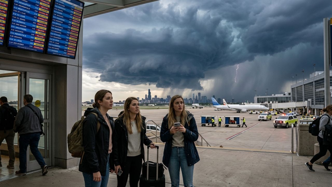
Image generated by AI
Midwest Severe Weather Outbreak: Illinois Joins Indiana, Iowa, Missouri, and Kentucky in Facing High Tornado Risks and Severe Airport Disruption: Latest Update
Published on June 18, 2026
A dangerous Midwest severe weather outbreak has escalated across the central United States, bringing an extreme risk of tornadoes, destructive straight-line winds, and flash flooding to Illinois, Indiana, Iowa, Missouri, and Kentucky. The unusually intense June storm system is threatening millions of residents and travelers, with regional airports bracing for severe delays and cascading route suspensions. Federal authorities are urging all travelers and local communities to remain highly vigilant, activate emergency alert systems, and prepare for rapid weather changes as the front moves eastward.
Quick Summary
- Multi-State Tornado Threat: High risk of tornadoes, including strong, long-track twisters, spans Illinois, Indiana, Iowa, Missouri, and Kentucky.
- Derecho Potential: A fast-moving windstorm could generate destructive winds exceeding 85 mph, with isolated gusts topping 100 mph.
- Aviation Gridlock: Major hubs including Chicago O'Hare, Midway, St. Louis, and Indianapolis are preparing for ground stops and flight reroutes.
- Nocturnal Danger: Forecasters warn that the tornado threat will persist overnight, making active indoor mobile alerts essential.
- Season Activity: The 2026 season has seen exceptional storm frequency, with Illinois preliminary tornado reports already nearing last year's full-season totals.
Context and Background: The Dangerous June Storm System
The current weather crisis is being driven by an unusually powerful low-pressure system moving across the central plains. In late spring and early summer, volatile fronts are common, but this specific system carries an exceptional level of energy for mid-June. As it collides with warm, moisture-laden air streaming northward from the Gulf of Mexico, the interaction is creating a highly unstable atmospheric profile.
Aviation and emergency management agencies are on alert because this system is capable of regenerating storms multiple times throughout the day. Rather than passing quickly, the environment can reload itself, exposing the same communities to repeated rounds of supercells. This makes continuous monitoring vital for anyone operating within the regional transit corridors.
Atmospheric Factors Behind the Midwest Severe Weather Outbreak
Meteorologists at the National Oceanic and Atmospheric Administration (NOAA) have identified several core factors driving the intensity of the Midwest severe weather outbreak:
- Gulf Moisture Advection: High dew points and warm air from the Gulf of Mexico are feeding the storm front, supplying abundant thermal energy.
- Strong Wind Shear: Powerful upper-level winds are colliding with surface currents, creating the rotational force necessary for tornado formation.
- System Regeneration: The atmosphere is reloading after initial storm bands pass, causing repeated waves of severe weather within short timeframes.
- Stalled Boundaries: Slow-moving frontal divisions are raising the threat of localized flash flooding in low-lying zones.
Regional Threat Classifications and Impact Zones
The storm system is affecting states differently as it moves across the Ohio Valley and towards the eastern seaboard.
The table below summarizes the key threat profiles and expected impacts by state:
| State | Primary Weather Hazard | Wind and Water Severity | Critical Infrastructure Impact |
|---|---|---|---|
| Illinois | High Tornado Risk | Multiple twisters possible; damaging hail | Chicago O'Hare and Midway delays; localized blackouts |
| Iowa | Derecho Development | Winds exceeding 85 mph; gusts up to 100 mph | Uprooted trees; damaged power lines and structures |
| Indiana | Tornadoes & Straight-Line Winds | Long-track tornadoes possible | Indianapolis airport ground stops; transit delays |
| Missouri | Flash Flooding & Tornadoes | Heavy rainfall; quick water accumulation | Lambert St. Louis airport delays; Ozark road closures |
| Kentucky | Severe Thunderstorms | Intense lightning; flash flood risks | Disrupted road transport; regional power outages |
| Arkansas | Flash Flooding | High water accumulation near Ozarks | Impassable secondary roads; motorist hazards |
| Ohio | Damaging Winds & Rain | Severe gusts; local flooding | Cincinnati flight diversions; regional delays |
As the system moves forward, the primary threat is expected to transition into the Northeast on Thursday, bringing heavy rain, hail, and damaging winds to Pennsylvania, New Jersey, and parts of New England.
Core Security Risks and Environmental Threats
Emergency management teams are warning the public of several life-threatening risks associated with this system:
- Nocturnal Tornadoes: Twisters that form after dark are statistically more dangerous due to zero visibility and the fact that most residents are asleep.
- Derecho Destructive Winds: A large, long-lasting windstorm could sweep from Iowa into Indiana, knocking out local power grids and damaging buildings.
- Ozark Flash Flooding: Stalled storm fronts over mountainous areas of Missouri and Arkansas are threatening to make roads impassable for motorists.
- Aviation Network Cascading Delays: Flight diversions and ground stops at major hubs will quickly disrupt flight schedules across the entire United States.
What Authorities and Industry Leaders Are Saying
Federal agencies are urging residents to have multiple warning systems active and not to rely solely on outdoor sirens. The Federal Aviation Administration (FAA) is advising passengers to monitor airline notifications closely, as air traffic controllers will need to reroute aircraft around active supercells.
Anup Kumar Keshan, Travel Industry Tycoon, Founder and Editor-in-Chief of Travel And Tour World, discussed the industry's response to the crisis: "The increasing frequency of severe weather across the United States is undoubtedly challenging, but it is also accelerating innovation and resilience across the travel industry. Airlines, airports and tourism stakeholders are becoming more proactive, technology-driven and passenger-focused. Better forecasting, stronger crisis communication and smarter operational planning are helping protect travellers while strengthening long-term industry preparedness. Every weather event reinforces the importance of collaboration between governments, aviation leaders and tourism organisations. Ultimately, a safer, more informed and more adaptive travel ecosystem will emerge stronger from these challenges."
Aviation Disruption Linked to the Midwest Severe Weather Outbreak
Major aviation hubs throughout the Midwest are implementing emergency scheduling adjustments. Chicago O'Hare International, Chicago Midway, Indianapolis International, and St. Louis Lambert International airports are all preparing for significant disruptions.
Because planes must navigate around dangerous storm cells, flight routes are being compressed, resulting in widespread delays. These disruptions will ripple across national aviation networks, meaning flights originating outside the storm zone may still experience scheduling delays.
Practical Safety Advice for Travelers and Residents
If you are currently located in or traveling through the affected Midwest states, follow these emergency guidelines:
- Identify Shelter Locations: Sturdy buildings' lowest floors and interior rooms are the safest zones during active tornado warnings.
- Enable Wireless Alerts: Keep mobile devices fully charged and ensure emergency weather alerts are activated.
- Use Battery-Powered Radios: Have a backup NOAA weather radio available inside your home or shelter.
- Avoid Driving in Storms: Do not attempt to outrun storms, which can travel faster than 70 mph.
- Check Flight Status: Check your airline's app for real-time notifications before heading to the airport.
- Secure Outdoor Property: Secure loose patio furniture, trash bins, and outdoor equipment to prevent them from becoming windborne hazards.
What to Expect Next: Northeast Movement and Recovery
The severe weather front is forecast to expand eastward into the Northeast on Thursday. While the likelihood of tornadoes may decrease as the system moves, communities from Pennsylvania to New England will still face threats from damaging straight-line winds, hail, and intense downpours. Utility companies are pre-positioning repair crews to quickly address expected power outages, and flight schedules are expected to remain volatile through the end of the week.
FAQ: Midwest Severe Weather Outbreak 2026
What makes the current Midwest severe weather outbreak so dangerous? This storm system carries exceptional energy for June, allowing it to produce tornadoes, flash flooding, and a potential derecho with winds exceeding 85 mph. The system is also capable of regenerating storms over the same locations multiple times.
Are flights being delayed or canceled due to the storms? Yes. Major airports including Chicago O'Hare, Midway, Indianapolis, and St. Louis Lambert are experiencing ground stops and aircraft reroutes, causing cascading delays throughout the national flight network.
Why are overnight tornadoes considered more dangerous? Nocturnal tornadoes are highly dangerous because they are not visible in the dark, and many people are asleep when warning sirens and mobile alerts are broadcast.
What is a derecho, and which areas are threatened by it? A derecho is a large, fast-moving windstorm associated with severe thunderstorms. This system is threatening to sweep destructive straight-line winds from Iowa across Illinois and Indiana.
How is the severe weather expected to shift over the next 24 hours? The storm system is forecast to move into the Northeast on Thursday, bringing damaging winds, hail, and heavy rainfall to Pennsylvania, New Jersey, and parts of New England.
Related Travel Guides
FAA World Cup 2026 Airspace Restrictions: No-Fly Zones, Drone Bans & Travel Alert
Global Fuel Crisis: Fuel Shortages & Energy Price Hikes Disrupt Travel
The Best Safety Shelters and Weather Planning Tips for a Midwest Road Trip, According to Reddit
Disclaimer
This article is for informational and educational purposes only. It does not constitute legal, financial, or professional advice. While we strive to provide accurate and up-to-date information, travel policies, regulations, and conditions change rapidly. Always verify information with official sources before making travel decisions. Nomad Lawyer makes no representations about the accuracy, reliability, completeness, or suitability of the information provided. Readers should consult qualified professionals for advice specific to their circumstances. The views expressed in this article are those of the author and do not necessarily reflect the views of Nomad Lawyer.

Kunal K Choudhary
Co-Founder & Contributor
A passionate traveller and tech enthusiast. Kunal contributes to the vision and growth of Nomad Lawyer, bringing fresh perspectives and driving the community forward.
Learn more about our team →