Delos Peril Level Rises as Mediterranean Sea Threatens Sacred Apollo Sanctuary
Rising Mediterranean sea levels place Greece's ancient Delos island—birthplace of Apollo—at critical risk in 2026. Chronic flooding threatens one of Europe's most significant archaeological sites as waters creep toward marble temples.
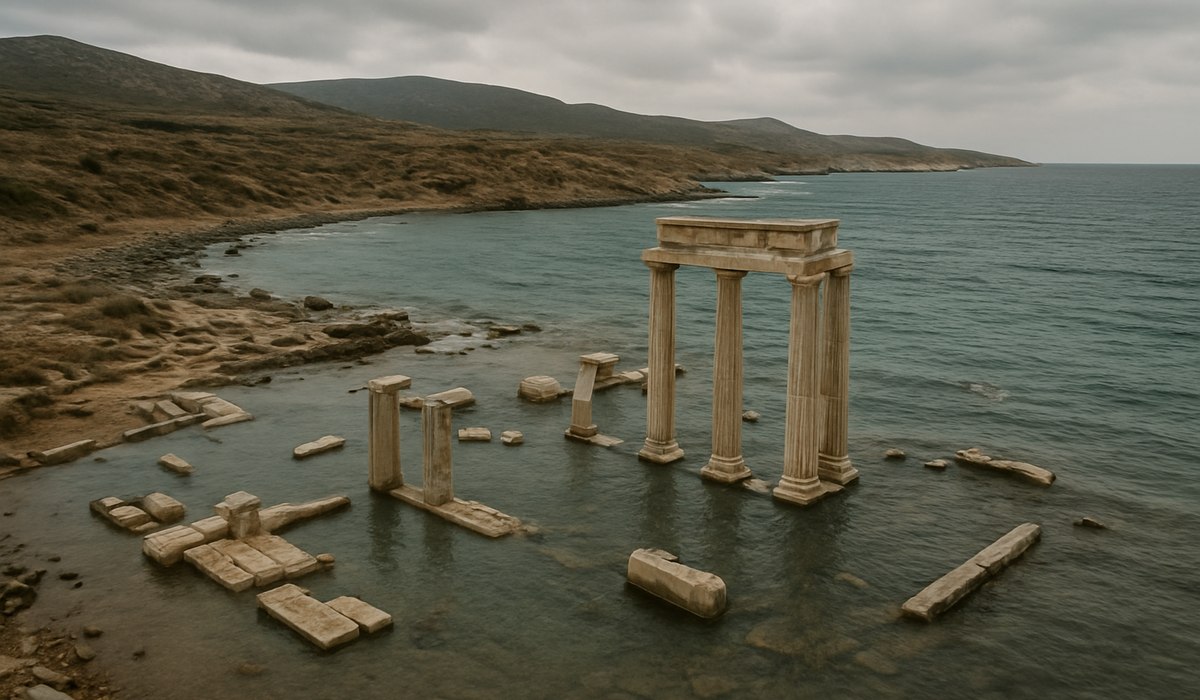
Image generated by AI
Greece's Sacred Island Faces Existential Climate Threat
Delos, the windswept Aegean sanctuary celebrated as the mythical birthplace of Apollo and Artemis, confronts an unprecedented environmental crisis in 2026. Rising Mediterranean waters now lap at the island's marble temples and ancient streets—transforming Europe's most iconic open-air archaeological site into a frontline case study for heritage preservation under climate pressure. What was once a thriving Hellenistic port now battles chronic flooding, saltwater intrusion, and accelerating coastal erosion that threatens irreplaceable cultural monuments dating back millennia.
The delos peril level has escalated significantly as scientific assessments confirm that portions of the sacred sanctuary already experience regular seasonal inundation. For travelers and heritage enthusiasts planning Aegean journeys, this development carries practical implications: access patterns are shifting, conservation zones are expanding, and the window to witness these treasures in their current state is narrowing.
An Ancient Port Turned Climate Front Line
Delos occupies a peculiar position in Mediterranean geography and human history. Located near Mykonos in the central Aegean, this compact island served antiquity as both a religious epicenter and a bustling commercial hub. The Sanctuary of Apollo, the famed Terrace of the Lions, quays, residential quarters, and marketplace installations all remain remarkably preserved—a rare open-air cityscape where ancient urban life literally emerges from the ground.
That same coastal proximity, however, has become a vulnerability. According to UNESCO's World Heritage documentation, Delos stretches nearly to the waterline along much of its shoreline, with critical structures sitting mere meters above current sea level. Recent field observations and satellite assessments reveal that lower-lying districts now experience recurring flooding during high tides and winter storms. Standing water pooling around mosaic floors, column bases, and foundational masonry has transformed from exceptional to routine.
The delos peril level assessment undertaken by Greek archaeological authorities confirms that even modest sea level increments translate into tangible heritage loss. Waterlogged soils weaken structural integrity, accelerate stone decay, and create conditions conducive to biological colonization that further destabilizes ancient fabric.
Accelerating Sea Level Rise in the Mediterranean
Recent climate research presents sobering projections for the Mediterranean basin. Regional sea level rise has outpaced twentieth-century trends in recent decades, with trajectory models indicating continued acceleration through 2100. For a site like Delos, which occupies such low elevation terrain, these incremental increases compound into catastrophic scenarios.
Academic climate impact studies specific to Delos estimate that under mainstream emissions pathways, local sea level could rise by several tens of centimeters by mid-century and exceed half a meter by century's end. These figures prove critical when combined with storm-driven wave action that already overwashes vulnerable sections seasonally.
The mechanism of damage extends beyond simple inundation. Saltwater intrusion penetrates ground layers and rises through capillary action—an invisible process accelerating decay in stone, mortar, and brick long before direct wave contact occurs. This chemical weathering destabilizes walls and sculptures silently over seasons and years. Additionally, advancing seas undercut fragile masonry, collapse retaining walls, and erode archaeological strata preserved intact for millennia. The Mediterranean World Heritage Programme has formally identified Delos among coastal locations facing heightened risk from both chronic flooding and shoreline erosion.
Heritage Under Water: Current Damage Assessment
Field monitoring reveals tangible degradation across the sanctuary's lower zones. Portions of the ancient waterfront, including harbor installations and docking quays, now sit partially submerged or perpetually waterlogged. Mosaic pavements that survived twenty-three centuries face accelerating dissolution from salt-laden moisture. Foundational systems that supported multi-story houses and public buildings weaken as groundwater saturation increases.
Greek research institutions have deployed climate monitoring systems capturing real-time environmental data around both landscape and monuments. Temperature, humidity, wind patterns, and marine conditions feed computer models simulating future scenarios. This mapping identifies which archaeological sectors face earliest and most severe impacts, enabling prioritized protective interventions.
Current damage concentrates in predictable zones: the ancient harbor districts, the lower terraces adjacent to the shoreline, and the western residential quarters where sea level rise directly threatens structural foundations. Artifacts previously considered secure now face seasonal or chronic water exposure that accelerates their deterioration substantially.
What's Being Done to Protect Delos
Greece has mobilized a coordinated national strategy addressing climate threats to major archaeological sites. Delos features prominently alongside Delphi and Ancient Olympia in comprehensive adaptation roadmaps developed collaboratively by climatologists, structural engineers, and archaeological specialists.
On-site protective measures already visible include elevation of vulnerable statues and architectural fragments onto higher platforms, positioning them above frequently-flooded zones. Targeted micro-drainage improvements redirect standing water away from critical structures. Strategic reinforcement shoring stabilizes vulnerable foundations. Movable artifacts undergo systematic relocation away from high-risk areas.
Discreet earthworks and temporary barriers now modulate water flow patterns across the sanctuary. These interventions aim to minimize standing water formation while preserving the site's authentic archaeological character. The delos peril level monitoring system provides early-warning data enabling rapid response when conditions deteriorate rapidly.
International collaboration through UNESCO and European heritage networks supports this work with technical expertise and funding mechanisms. The objective balances urgent stabilization with long-term adaptive management as environmental pressures continue mounting through the 2030s and beyond.
Data Overview: Delos Climate Vulnerability Metrics
| Metric | Current Measurement | 2050 Projection | 2100 Projection |
|---|---|---|---|
| Sea Level Rise (Mediterranean average) | +1.8 mm annually | +10–15 cm cumulative | +50–100+ cm cumulative |
| Delos Elevation (lowest points) | 0.5–2.0 m above current sea level | Marginal submersion risk increases | Chronic inundation likely |
| Flooding Frequency (lower districts) | Seasonal to episodic | Monthly to seasonal events | Permanent or near-permanent saturation |
| Saltwater Intrusion Depth | 0.3–0.8 m into subsurface | 1.0–1.5 m penetration | 2.0+ m penetration |
| At-Risk Archaeological Structures | ~35–40% of site perimeter | ~50–60% of site | ~70–80% of site |
| Storm Surge Intensity (100-year events) | 1.2–1.5 m above mean high tide | 1.5–2.0 m | 2.0–3.0+ m |
| Active Conservation Interventions | 12–15 major projects | 25–35 projects | 40+ adaptive strategies |
What This Means for Travelers
The rising delos peril level carries direct implications for visitors planning Aegean journeys:
-
Access windows are narrowing: Plan visits sooner rather than later. Expanded conservation zones and protective barriers limit exploration areas periodically, especially during high-risk seasons (November through March).
-
Seasonal timing matters: Visit during summer months (June–September) when sea levels reach their lowest and flooding risk diminishes. Winter storm surge poses genuine accessibility challenges.
-
Guided tours recommended: Professional archaeological guides provide context on conservation work and accessible zones, enhancing educational value while respecting active protection efforts.
-
Artifact visibility shifting: Movable treasures undergo strategic relocation to higher-elevation museums and climate-controlled facilities. Expect changes from previous visits regarding what's displayed on-site versus in nearby Mykonos museums.
-
Photography documentation encouraged: Capture current conditions while possible. These images create valuable heritage records as the site evolves.
-
Verify access before booking: Contact the Delos
Disclaimer
This article is for informational and educational purposes only. It does not constitute legal, financial, or professional advice. While we strive to provide accurate and up-to-date information, travel policies, regulations, and conditions change rapidly. Always verify information with official sources before making travel decisions. Nomad Lawyer makes no representations about the accuracy, reliability, completeness, or suitability of the information provided. Readers should consult qualified professionals for advice specific to their circumstances. The views expressed in this article are those of the author and do not necessarily reflect the views of Nomad Lawyer.

Raushan Kumar
Founder & Lead Developer
Full-stack developer with 11+ years of experience and a passionate traveller. Raushan built Nomad Lawyer from the ground up with a vision to create the best travel and law experience on the web.
Learn more about our team →